List of earthquakes in Turkey
This is a list of earthquakes in Turkey, including any notable historical earthquakes that have epicenters within the current boundaries of Turkey, or which caused significant effects in this area. This list is incomplete.
Tectonic setting
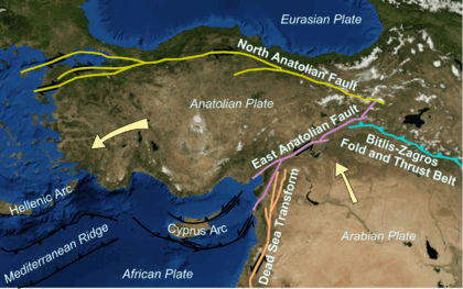
Turkey is a seismically active area within the complex zone of collision between the Eurasian Plate and both the African and Arabian Plates. Much of the country lies on the Anatolian Plate, a small plate bounded by two major strike-slip fault zones, the North Anatolian Fault and East Anatolian Fault. The western part of the country is also affected by the zone of extensional tectonics in the Aegean Sea caused by the southward migration of the Hellenic arc. The easternmost part of Turkey lies on the western end of the Zagros fold and thrust belt, which is dominated by thrust tectonics.
Seismic hazard
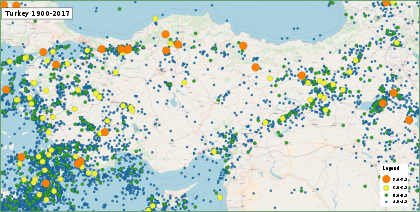
Seismic hazard in Turkey is highest along the plate boundaries, but there is a significant risk of damaging earthquakes almost anywhere in the country. Seismic maps that show risk have changed through time.[1]
List of notable earthquakes
| Date | Time‡ | Place | Lat | Long | Deaths | Mag. | Comments | Sources |
|---|---|---|---|---|---|---|---|---|
| 17 CE | n/a | Philadelphia (Alaşehir) | 38.21 | 28.31 | n/a | n/a | see AD 17 Lydia earthquake | [2] |
| December 13, 115 | Antioch | 36.1 | 36.1 | ~260,000 | 7.5 Ms | see 115 Antioch earthquake | [3] | |
| 141 (or 142) | Lycia, Caria, Dodecanese | 36.7 | 28.0 | n/a | VIII | Triggered a severe tsunami that caused inundation at Rhodes; see 141 Lycia earthquake | [4] | |
| 262 | South and west coasts of Anatolia | 36.5 | 27.8 | n/a | IX | Damaged many buildings at Ephesus and triggered a tsunami that hit coastal cities; see 262 Southwest Anatolia earthquake | [5] | |
| May 19, 526 | Antioch | 250,000 | VIII | The city of Antioch was greatly damaged, and some decades later the city's population was just 300,000. see 526 Antioch earthquake | [6] | |||
| August 15, 554 | Anatolia | The earthquake severely damaged the city of Tralles (modern Aydın) and the island of Kos; See 554 Anatolia Earthquake | [7] | |||||
| December 14, 557 | just before midnight | Constantinople | 40.9 | 28.7 | n/a | X (Intense) | Constantinople was "almost completely razed to the ground" by the earthquake. see 557 Constantinople earthquake | [8] |
| 1268 | Cilicia, Anatolia | 37.5 | 35.5 | 60,000 | ~7 | see 1268 Cilicia earthquake | – | |
| September 10, 1509 | Constantinople | 40.9 | 28.7 | 10,000 | 7.2 Mw | see 1509 Constantinople earthquake | – | |
| February 23, 1653 | Smyrna | 38.2 | 28.2 | 2,500 | 7.5 | see 1653 East Smyrna earthquake | [9] | |
| August 17, 1668 | Anatolia | 40 | 36 | 8,000 | 8 | see 1668 North Anatolia earthquake | USGS | |
| July 10, 1688 | 11:45 | Smyrna | 38.4 | 26.9 | 16,000 | 7.0 Ms | see 1688 Smyrna earthquake | [10] |
| May 22, 1766 | 05:10 | Istanbul | 40.8 | 29.0 | 4,000 | 7.1 Ms | see 1766 Istanbul earthquake | [11] |
| February 28, 1855 | 01:00 | Bursa | 40.2 | 29.1 | 1,900 | 6.7 | see 1855 Bursa earthquake | [12] |
| June 2, 1859 | 10:30 | Erzurum | 39.9 | 41.3 | 15,000 | 6.1 Ms | see 1859 Erzurum earthquake | [13] |
| April 3, 1881 | 11:30 | Chios, Çeşme, Alaçatı | 38.25 | 26.25 | 7,866 | 7.3 Mw | see 1881 Chios earthquake | [14] |
| October 10, 1883 | 13:30 | Çeşme, Izmir, Ayvalik | 38.3 | 26.2 | 120+ | 7.3 Ms | see 1883 Çeşme earthquake | [15] |
| July 10, 1894 | 12:24 | Gulf of Izmit | 40.73 | 29.25 | 1,300 | 7.0 | see 1894 Istanbul earthquake | [16] |
| April 29, 1903 | 01:46 local time | Malazgirt | 39.14 | 42.65 | 600 | 6.7 Ms | see 1903 Manzikert earthquake | [17][18] |
| August 9, 1912 | 03:29 local time | Mürefte | 40.75 | 27.2 | 216 | 7.3 MS | see 1912 Mürefte earthquake | [17][18] |
| October 4, 1914 | 00:07 local time | Burdur | 37.82 | 30.27 | 2,344 | 6.9 MS | see 1914 Burdur earthquake | [17][18] |
| September 13, 1924 | 16:34 local time | Horasan | 40.0 | 42.1 | 60 | 6.8 | see 1924 Pasinler earthquake | [17][18] |
| October 22, 1926 | 21:59 local time | Kars | 40.7 | 43.7 | 360 | 6.0 Ms | see 1926 Kars earthquake | [19] |
| March 31, 1928 | 02:29 local time | Smyrna | 38.5 | 28.0 | 50 | 6.5 MS | Possible M=6.2 foreshock previous day | [17][18] |
| May 18, 1929 | 08:37 local time | Suşehri | 40.2 | 37.9 | 64 | 6.1 | Ms | [17][18] |
| May 7, 1930 | 00:34 local time | Hakkâri | 38.1 | 44.7 | 2,514 | 7.2–7.5 Ms | see 1930 Salmas earthquake | [20] |
| January 4, 1935 | 16:41 local time | Erdek | 40.4 | 27.5 | 5 | 6.4 Ms | [17][18] | |
| April 19, 1938 | 12:59 local time | Kırşehir | 39.1 | 34.0 | 160 | 6.6 MS | see 1938 Kırşehir earthquake | [17][18] |
| September 22, 1939 | 02:36 local time | Dikili | 39.1 | 26.8 | 60 | 6.6 MS | [17][18] | |
| December 26, 1939 | 23:57 | Erzincan | 39.77 | 39.53 | 32,700 | 7.8 Mw | see 1939 Erzincan earthquake | USGS |
| November 15, 1942 | 19:01 local time | Bigadiç | 39.2 | 28.2 | 16 | 6.1 MS | [17][18] | |
| December 20, 1942 | 14:03 | Erbaa | 40.87 | 36.47 | 3,000 | 7.0 Ms | see 1942 Niksar–Erbaa earthquake | [21] |
| June 20, 1943 | 17:32 local time | Hendek | 40.6 | 30.5 | 336 | 6.6 MS | [17][18] | |
| November 26, 1943 | 22:20 | Ladik | 40.87 | 33.65 | 2,824–5,000 | 7.5 Mw | see 1943 Tosya–Ladik earthquake | |
| February 1, 1944 | 03:25 | Gerede | 40.8 | 32.2 | 3,959 | 7.5 | see 1944 Bolu–Gerede earthquake | [21] |
| October 6, 1944 | 04:34 local time | Ayvalık | 39.37 | 26.53 | 30 | 6.8 MS | [17][18] | |
| August 17, 1949 | Karlıova | 39.54 | 40.57 | 450 | 6.8 | see 1949 Karlıova earthquake | [21] | |
| August 13, 1951 | 18:36 | Kurşunlu | 40.88 | 32.87 | 50 | 6.9 | see 1951 Kurşunlu earthquake | [21] |
| March 18, 1953 | 21:06 local time | Yenice | 40.02 | 27.53 | 265 | 7.2 MS | see 1953 Yenice–Gönen earthquake | [17][18] |
| July 16, 1955 | 09:07 local time | Söke | 37.55 | 27.05 | 23 | 6.8 MS | [17][18] | |
| April 25, 1957 | 04:25 local time | Fethiye | 36.5 | 28.6 | 67 | 7.1 MS | see 1957 Fethiye earthquakes | [17][18] |
| May 26, 1957 | 6:36 | Abant | 40.67 | 31.00 | 52 | 7.1 | see North Anatolian Fault | [21] |
| October 6, 1964 | 16:31 local time | Manyas | 40.1 | 27.93 | 23 | 7.0 MS | [17][18] | |
| August 19, 1966 | 12:23 | Varto | 39.17 | 41.56 | 2,394 | 6.8 Mw | see 1966 Varto earthquake | [21] |
| July 22, 1967 | 16:56 | Mudurnu | 40.67 | 30.69 | 89 | 7.2 | see North Anatolian Fault | [21] |
| September 3, 1968 | 10:19 local time | Bartın | 41.79 | 32.31 | 29 | 6.5 MS | [17][18] | |
| March 28, 1969 | 03:48 local time | Alaşehir | 38.5 | 28.4 | 53 | 6.5 MS | [17][18] | |
| March 28, 1970 | 23:02 local time | Gediz | 39.2 | 29.5 | 1,086 | 7.2 MS | see 1970 Gediz earthquake | [17][18] |
| May 22, 1971 | 16:44 | Bingöl | 38.83 | 40.52 | 755 | 6.9 Mw | see 1971 Bingöl earthquake | [22] |
| September 6, 1975 | 12:20 local time | Lice | 38.5 | 40.7 | 2,311 | 6.6 MS | see 1975 Lice earthquake | [17][18] |
| November 24, 1976 | 14:22 local time | Muradiye | 39.12 | 44.03 | 4,000 | 7.5 MS | see 1976 Çaldıran–Muradiye earthquake | [17][18] |
| October 30, 1983 | 07:12 local time | Erzurum | 40.33 | 42.19 | 1,342 | 6.9 MS | see 1983 Erzurum earthquake | [17][18] |
| March 13, 1992 | 17.18 | Erzincan | 39.70 | 39.69 | 498 | 6.7 Mw | see 1992 Erzincan earthquake | [23] |
| October 1, 1995 | 17:57 local time | Dinar | 38.06 | 30.13 | 90 | 6.1 MS | see 1995 Dinar earthquake | [17][18] |
| June 27, 1998 | 16:55 local time | Ceyhan | 36.88 | 35.31 | 146 | 6.3 Mw | see 1998 Adana–Ceyhan earthquake | [17][18] |
| August 17, 1999 | 03:02 local time | Izmit | 40.77 | 30 | 17,127 | 7.6 Mw | see 1999 İzmit earthquake | USGS |
| November 12, 1999 | 18:57 local time | Düzce | 40.75 | 31.16 | 894 | 7.2 Mw | (PDE Monthly Listing); see 1999 Düzce earthquake | USGS |
| February 3, 2002 | 07:11 | Afyon | 38.573 | 31.271 | 44 | 6.5 Mw | (HRV); see 2002 Afyon earthquake | [25] |
| January 27, 2003 | 05:26 | Pülümür | 39.46 | 39.79 | 1 | 6.1 Mw | (HRV, USGS) | USGS |
| May 1, 2003 | 00:27 | Bingöl | 39.01 | 40.46 | 177 | 6.4 Mw | (HRV, USGS); see 2003 Bingöl earthquake | [26] |
| July 2, 2004 | 01:30 | Ağrı | 39.71 | 44.02 | 18 | 5.1 Mw | (HRV); see 2004 Doğubayazıt earthquake | [27] |
| March 8, 2010 | 02:32 | Elâzığ | 38.79 | 40.03 | 41 | 6.1 Mw | (HRV); see 2010 Elazığ earthquake | [28] |
| May 19, 2011 | 23:15 | Kütahya | 39.14 | 29.07 | 2 | 5.8 Mw | (HRV); see 2011 Kütahya earthquake | [29] |
| October 23, 2011 | 13:41 | Van | 38.63 | 43.49 | 604 | 7.2 Mw | (HRV); see 2011 Van earthquakes | [30] |
| November 09, 2011 | 19:23 | Van | 38.42 | 43.22 | 40 | 5.6 Mw | (HRV): see 2011 Van earthquakes | [31] |
| May 24, 2014 | 12:25 local time | Imbros | 40.31 | 25.45 | 0 | 6.9 Mw | (HRV); see 2014 Aegean Sea earthquake | [32] |
| June 12, 2017 | 15:28 local time | Lesbos, Greece | 38.93 | 26.37 | 1 (in the Greek island of Lesbos) | 6.3 Mw | (HRV); see 2017 Lesbos earthquake | [33] |
| July 21, 2017 | 01:31 local time | Bodrum | 36.92 | 27.41 | 2 (in the Greek island of Kos) | 6.6 Mw | (HRV); see 2017 Aegean Sea earthquake | [34] |
| September 26, 2019 | 13:59 local time | Marmara Region | 40.89 | 28.17 | 1 | 5.7 Mw | (HRV); see 2019 Istanbul earthquake | [35] |
| January 24, 2020 | 20:55 local time | Elazığ, Malatya | 38.390 | 39.081 | 41 | 6.7 Mw | (HRV); see 2020 Elazığ earthquake | [36] |
| February 23, 2020 | 08:53 local time
19:00 local time |
Iran-Turkey border | 38.3943
38.3943 |
44.3405
44.3405 |
10 | 5.8 Mw
6.0 Mw |
(HRV); see 2020 Iran–Turkey earthquakes | [37][38] |
| June 14, 2020 | 16:24 local time | Bingöl | 39.42 | 40.67 | 1 | 5.9 Mw | [39] |
References
- Akkar, Sinan; Eroğlu Azak, Tuba; Can, Tolga; Çeken, U.; Demircioglu, Mine; Duman, Tamer; Erdik, M.; Ergintav, Semih; Kadirioğlu, Filiz; Kalafat, Doğan; Kale, Özkan (2018-07-13). "Evolution of seismic hazard maps in Turkey". Bulletin of Earthquake Engineering. 16 (8): 3197–3228. doi:10.1007/s10518-018-0349-1.
- The Internet Classics Archive. "Tacitus Annales Book 2, 47". Retrieved 21 June 2013.
- National Geophysical Data Center. "Comments for the Significant Earthquake". Retrieved 19 October 2011.
- "Comments for the tsunami event". Significant Earthquake Database. National Geophysical Data Center. Retrieved 8 February 2015.
- "Turkey: S Coasts; Libya: Comments for the Earthquake Event". Significant Earthquake Database. National Geophysical Data Center. Retrieved 4 October 2016.
- Procopius, II.14.6; sources based on John of Ephesus
- https://www.annalsofgeophysics.eu/index.php/annals/article/viewFile/4702/4786
- Agathias; Frendo, Joseph D. (1975), The histories, Walter de Gruyter, ISBN 978-3-11-003357-1
- NGDC. "Comments for the 1653 Earthquake". Retrieved 1 February 2011.
- NGDC. "Comments for the 1688 Earthquake". Retrieved 1 February 2011.
- N. N. Ambraseys; J. A. Jackson (June 2000). "Seismicity of the Sea of Marmara (Turkey) since 1500". Geophysical Journal International. 141 (3).
- NGDC. "Comments for the 1855 Earthquake". Retrieved 2 February 2011.
- NGDC. "Comments for the 1859 Earthquake". Retrieved 1 February 2011.
- NGDC. "Comments for the 1881 Earthquake". Retrieved 2 February 2011.
- NCEI. "Comments for the 1883 earthquake". Retrieved 3 March 2018.
- Ambraseys, N. (January 2001). "The earthquake of 10 July 1894 in the Gulf of Izmit (Turkey) and its relation to the earthquake of 17 August 1999". Journal of Seismology. 5 (1): 117–128. Bibcode:2001JSeis...5..117A. doi:10.1023/A:1009871605267. ISSN 1573-157X.
- Bogazici University Kandilli Observatory and Earthquake Research Institute National Earthquake Monitoring Center (NEMC). "List of large earthquakes 1900–2004" (in Turkish). Retrieved 2 February 2020.
- IISEENET (Information Network of Earthquake disaster Prevention Technologies) – Search Page
- NGDC. "Comments for the 1926 Earthquake". Retrieved 3 February 2011.
- NGDC. "Comments for the 1930 Earthquake". Retrieved 3 February 2011.
- Toksoz, M.N., Shakal, A.F. & Michael, A.J. 1979. Space-Time Migration of Earthquakes Along the North Anatolian Fault Zone and Seismic Gaps. Pageophys, 117, 1258–1270.
- USGS list of earthquakes with 1,000 or More Deaths since 1900 Archived 2008-10-11 at the Wayback Machine
- Bernard, P., Gariel, J-C. & Dorbath L. 1997. Fault location and rupture kinematics of the magnitude 6.8, 1992 Erzincan earthquake, Turkey, from strong ground motion and regional records. Bulletin Seismological Society of America, 87, 1230–1243.
- Marza, Vasile I. (2004). "On the death toll of the 1999 Izmit (Turkey) major earthquake" (PDF). ESC General Assembly Papers, Potsdam: European Seismological Commission. Archived from the original (PDF) on 2008-04-09. Cite journal requires
|journal=(help) - USGS. "Significant Earthquakes of the World 2002".
- USGS. "Significant Earthquakes of the World 2003".
- "M 5.1 - eastern Turkey". USGS.com. United States Geological Survey. 2004-07-01. Retrieved 8 October 2019.
- USGS. "Magnitude 6.1 – eastern Turkey". Archived from the original on 2010-03-11.
- USGS. "Magnitude 5.8 – WESTERN TURKEY".
- USGS. "Magnitude 7.2 – EASTERN TURKEY". Archived from the original on 2011-10-24.
- "M 5.6 - eastern Turkey". Earthquake.usgs.gov. Retrieved 2020-01-28.
- 24 MAYIS 2014 GÖKÇEADA AÇIKLARI - EGE DENİZİ DEPREMİ, Kandilli Observatory (Retrieved 2 January 2018)
- USGS. "Magnitude 6.3 – Plomarion Greece".
- USGS. "Magnitude 6.6 – WESTERN TURKEY".
- "Istanbul earthquake: Magnitude 5.8 quake hits Turkey". independent.co.uk. Retrieved 2019-09-26.
- "Rescue efforts under way after deadly quake rattles east Turkey". Aljazeera. 26 January 2020. Retrieved 26 January 2020.
- "M 5.8 - 25km SE of Saray, Turkey". earthquake.usgs.gov. Retrieved 2020-02-23.
- "M 6.0 - 25km SE of Saray, Turkey". earthquake.usgs.gov. Retrieved 2020-02-23.
- earthquake.usgs.gov https://earthquake.usgs.gov/earthquakes/eventpage/us6000abnv/executive. Retrieved 2020-06-16. Missing or empty
|title=(help)
List of earthquakes in Asia | |
|---|---|
| Sovereign states |
|
| States with limited recognition |
|
| Dependencies and other territories |
|
| |