List of earthquakes in Taiwan
This list of earthquakes in Taiwan charts significant earthquakes which have affected the island of Taiwan.
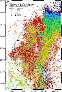
Taiwan is in a seismically active zone, on the Pacific Ring of Fire, and at the western edge of the Philippine Sea Plate.[1] Geologists have identified 42 active faults on the island, but most of the earthquakes detected in Taiwan are due to the convergence of the Philippine Sea plate and the Eurasian Plate to the east of the island.[1][2] Most of the earthquakes registered in Taiwan actually occur off the east coast and cause little damage, whereas smaller quakes beneath the island itself have historically proven more destructive. The first recorded earthquake in Taiwan was in 1624, the founding year of Dutch Formosa.[3] Between 1901 and the year 2000 there were 91 major earthquakes in Taiwan, 48 of them resulting in loss of life.[4] The most recent major earthquake was the 921 earthquake, which struck on 21 September 1999, and claimed 2,415 lives.
Many modern buildings in Taiwan are constructed with earthquake safety in mind, including Taipei 101, which had to cope with the dual challenges of being flexible enough to withstand earthquakes, yet rigid enough to resist wind shear. The High Speed Rail system incorporates an automatic safety device to safely bring all trains to a halt when a significant earthquake is detected.[5] Nevertheless, poor construction standards have been blamed for casualties in a number of major earthquakes, including the 1906 Meishan earthquake and the 921 earthquake. Inside Taiwan the Central Weather Bureau is the organisation responsible for monitoring and reporting on earthquakes. Large earthquakes are also assessed by the United States Geological Survey. Scientific studies of the seismology of the island started in the Japanese era, when the first seismograph was installed in Taipei by Fusakichi Omori's company.[6]
Earthquakes
Significant earthquakes are listed here from 1736 to the present. Starting with the Japanese era in 1895 there were major improvements in detection technology, allowing more detailed gathering of data.
| Date | Areas | Lat | Long | Depth (km) |
Mag. | MMI | Deaths | Injuries | Houses destroyed / notes | |
|---|---|---|---|---|---|---|---|---|---|---|
| 2019-08-08 | Yilan | 24.475 | 121.947 | 10.0 | 5.9 Mw | VI | 1 | |||
| 2019-04-18 | Hualien | 24.06 | 121.54 | 18.8 | 6.1 Mw | VI | 1 | 16 | ||
| 2018-02-06 | Hualien | 24.10 | 121.75 | 10.6 | 6.4 Mw | VIII | 17 | 277 | some buildings collapsed | [7] |
| 2017-02-10 | Tainan, Taipei | 22.83 | 120.22 | 15.8 | 5.3 Mw | VII | 4 | power outage | [8] | |
| 2016-02-06 | Tainan, Kaohsiung | 22.94 | 120.59 | 23 | 6.4 Mw | VII | 117 | 550 | 9 | [9][10] |
| 2015-04-20 | Yilan | 24.05 | 122.37 | 5 | 6.4 Mw | V | 1 | |||
| 2013-10-31 | Hualien | 23.62 | 121.43 | 19.5 | 6.3 Mw | VII | 0 | |||
| 2013-06-02 | Island-wide | 23.87 | 121.0 | 10.0 | 6.2 Mw | VII | 5 | 18 | ||
| 2013-03-27 | Island-wide | 23.9 | 121.07 | 19.4 | 5.9 Mw | V | 1 | 97 | ||
| 2012-02-26 | Pingtung | 22.75 | 120.75 | 26.3 | 6.4 | 0 | ||||
| 2010-03-04 | Kaohsiung | 22.92 | 120.73 | 5 | 6.3 Mw | VI | 96 | |||
| 2009-12-19 | Hualien | 23.76 | 121.69 | 43 | 6.4 Mw | VI | 6 | |||
| 2006-12-26 | Pingtung | 21.69 | 120.56 | 44.1 | 7.1 Mw | VII | 2 | 3 | ||
| 21.97 | 120.42 | 50.2 | 6.9 Mw | V | ||||||
| 2004-05-01 | Hualien | 24.1 | 121.95 | 17.8 | 5.8 | 2 | ||||
| 2002-05-15 | Yilan, Hualien | 24.6 | 121.9 | 5 | 6.2 Mw | VI | 1 | |||
| 2002-03-31 | Hualien, Taipei | 24.2 | 122.1 | 9.6 | 7.1 Mw | 7 | 6 | |||
| 2000-06-11 | Nantou | 23.9 | 121.1 | 10.2 | 6.4 Mw | 2 | ||||
| 2000-05-17 | Nantou | 24.2 | 121.1 | 3 | 5.3 | 3 | ||||
| 1999-09-21 | Island-wide | 23.9 | 120.8 | 8 | 7.7 Mw | X+ | 2,415 | 51,711 | ||
| 1998-07-17 | Nantou | 23.5 | 120.7 | 3 | 6.2 | 5 | ||||
| 1995-06-25 | Yilan | 24.6 | 121.7 | 40 | 6.0 Mw | 1 | 6 | |||
| 1995-02-23 | Hualien | 24.2 | 121.7 | 21.7 | 6.2 Mw | 2 | ||||
| 1994-09-16 | Taiwan Strait | 22.5 | 118.7 | 13 | 6.8 Mw | 0 | 0 | |||
| 1994-06-05 | Yilan | 24.4 | 121.8 | 5.3 | 6.4 Mw | VII | 1 | 1 | ||
| 1990-12-13 | Hualien | 23.9 | 121.5 | 3 | 6.7 Mw | VII | 2 | 3 | ||
| 1986-11-15 | Hualien | 24.0 | 121.8 | 15 | 7.4 Mw | VIII | 15 | 37 | ||
| 1986-05-20 | Hualien | 24.1 | 121.6 | 16 | 6.2 Mw | VIII | 1 | |||
| 1982-01-23 | Yilan, Hualien | 24.0 | 121.6 | 3 | 6.5 | 1 | ||||
| 1978-12-13 | Hualien | 23.3 | 121.6 | 4 | 7.0 Mw | VI | 2 | |||
| 1972-04-24 | Hualien | 23.5 | 121.4 | 15 | 7.0 Mw | VII | 5 | 50 | ||
| 1972-01-25 | Taitung | 22.5 | 122.3 | 33 | 7.3 Mw | VI | 1 | 5 | ||
| 1967-10-25 | Yilan | 24.4 | 122.1 | 20 | 6.8 Mw | VII | 2 | 21 | ||
| 1966-03-13 | Hualien | 24.2 | 122.7 | 42 | 7.5 Mw | VII | 4 | 24 | ||
| 1964-01-18 | Chiayi, Tainan | 23.2 | 120.6 | 18 | 6.5 Mw | VI | 106 | 10,924 | ||
| 1963-03-04 | Yilan | 24.6 | 121.1 | 5 | 6.3 Mw | 1 | ||||
| 1963-02-13 | Yilan | 24.35 | 122.06 | 47 | 7.2 Mw | VII | 3–15 | 3–18 | 6 | |
| 1959-08-15 | Pingtung | 21.7 | 121.3 | 20 | 7.1 | 16 | 1,214 | |||
| 1959-04-27 | Northeast Taiwan | 24.1 | 123.0 | 150 | 7.7 | 1 | 9 | |||
| 1957-10-20 | Hualien | 23.7 | 121.5 | 10 | 6.6 | 4 | ||||
| 1957-02-24 | Hualien | 23.8 | 121.8 | 30 | 7.3 | 11 | 44 | |||
| 1951-11-25 | Hualien | 23.3 | 121.3 | 7.3 | 17 | |||||
| 1951-10-22 | Hualien | 23.9 | 121.7 | 4 | 7.3 | 68 | ||||
| 1946-12-05 | Tainan | 23.1 | 120.3 | 5 | 6.1 | 74 | 1,954 | |||
| 1943-12-02 | Taitung | 22.5 | 121.5 | 40 | 6.8 Mw | 3 | 139 | |||
| 1943-10-23 | Hualien | 23.8 | 121.5 | 5 | 6.2 | 1 | 1 | |||
| 1941-12-17 | Chiayi | 23.4 | 120.5 | 12 | 7.1 | 360 | 4,520 | |||
| 1935-07-17 | Hsinchu, Taichung | 24.6 | 120.7 | 30 | 6.2 | 44 | 1,734 | |||
| 1935-04-21 | Miaoli, Taichung | 24.4 | 120.8 | 5 | 7.1 | 3,276 | 17,907 | |||
| 1930-12-08 | Tainan | 23.3 | 120.4 | 20 | 6.3 Mw | 4 | 49 | |||
| 1927-08-25 | Tainan | 23.3 | 120.5 | 6.8 Muk | 9–30 | 27–100 | 200–214 | NGDC | ||
| 1922-12-02 | Hualien | 24.6 | 122.0 | 6.0 | 1 | 1 | ||||
| 1922-10-15 | Hualien | 24.6 | 122.3 | 20 | 5.9 | 6 | ||||
| 1922-09-22 | Hualien | 24.5 | 122 | 20 | 7.6 | 5 | 14 | |||
| 1920-06-05 | Hualien | 24.6 | 121.9 | 20 | 8.3 | 5 | 273 | |||
| 1917-01-07 | Central Taiwan | 23.9 | 120.9 | shallow | 5.5 | 187 | ||||
| 1917-01-05 | Central Taiwan | 24.0 | 121.0 | shallow | 6.2 | 54 | 130 | |||
| 1916-11-15 | Central Taiwan | 24.1 | 120.9 | 3 | 6.2 | 1 | 97 | |||
| 1916-08-28 | Central Taiwan | 24.0 | 121.0 | 45 | 6.8 | 16 | 614 | |||
| 1910-04-12 | Keelung | 25.1 | 122.9 | 200 | 8.3 | 13 | ||||
| 1909-04-15 | Taipei | 23.7 | 121.5 | 80 | 7.3 | 9 | 122 | |||
| 1908-01-11 | Hualien | 23.7 | 121.4 | 10 | 7.3 | 2 | 3 | |||
| 1906-04-14 | Tainan | 23.4 | 120.4 | 20 | 6.6 | 15 | 1,794 | |||
| 1906-03-17 | Chiayi | 23.6 | 120.5 | 6 | 6.8 Ms | IX | 1,258–1,266 | 2,385– 2,476 | 14,218–30,021 | |
| 1904-11-06 | Chiayi | 23.6 | 120.3 | 7 | 6.1 | 145 | 661 | |||
| 1904-04-24 | Chiayi | 23.5 | 120.3 | – | 6.1 | 3 | 66 | |||
| 1897-03-15 | Yilan, Taipei | – | – | – | – | 56 | 50 | |||
| 1882-12-09 | Island-wide | 23.0 | 121.4 | – | ~7.5 | 10 | 40 | |||
| 1881-02-18 | Taipei, Hsinchu, Miaoli | 24.6 | 120.7 | – | ~6.2 | 11 | 210 | |||
| 1867-12-18 | Taipei, Keelung, Hsinchu | 25.3 | 121.7 | – | ~7.0 | hundreds | ||||
| 1865-11-06 | Taipei, Keelung | 24.9 | 121.6 | – | ~6.0 | "many" | ||||
| 1862-06-07 | Tainan, Chiayi, Changhua | 23.2 | 120.2 | – | ~7.0 | over 500 | over 500 | |||
| 1848-12-03 | Tainan, Changhua, Chiayi | 24.1 | 120.5 | – | ~7.1 | 1,030 | 13,993 | |||
| 1845-03-04 | Chiayi, Changhua, Taichung | 24.1 | 120.7 | – | ~6.0 | 381 | 4220 | |||
| 1815-10-13 | From Chiayi northwards | 24.0 | 121.7 | – | ~7.7 | 113 | 243 | |||
| 1811-03-17 | From Chiayi northwards | 23.8 | 121.8 | – | ~7.5 | 21 | 41 | |||
| 1792-08-09 | Chiayi, Changhua, Yunlin | 23.6 | 120.5 | – | ~7.1 | 617 | 24,621 | |||
| 1736-01-30 | Tainan | 23.1 | 120.5 | – | ~6.5 | 372 | 698 | |||
| Muk = Unknown magnitude scale, ML = Richter magnitude scale, Ms = surface wave magnitude, and Mw = moment magnitude scale. The inclusion criteria for adding events are based on WikiProject Earthquakes' notability guideline that was developed for stand alone articles. The principles described are also applicable to lists. In summary, only damaging, injurious, or deadly events should be recorded. | ||||||||||
See also
References
- Taiwan Yearbook 2005, p. 23
- Yu, S.B.; Chen, H.Y.; Kuo, L.C. (1997). "Velocity field of GPS stations in the Taiwan area". Tectonophysics. 274 (1–3): 41–59. Bibcode:1997Tectp.274...41Y. doi:10.1016/S0040-1951(96)00297-1.
- "Archived copy" 二十世紀前 (1604–1900) 台灣地區的地震記載. Central Weather Bureau. Archived from the original on 2010-12-14. Retrieved 2009-07-20.CS1 maint: archived copy as title (link)
- "Archived copy" 二十世紀 (1901–2000) 台灣地區災害性地震 (in Chinese). Central Weather Bureau. Archived from the original on 2018-04-25. Retrieved 2009-07-17.CS1 maint: archived copy as title (link)
- "SHATTERED BELIEF: Biting the bullet". Asahi Shimbun. Retrieved 2009-07-20.
- Davidson, Charles (1927). The Founders of Seismology. p. 223.
- "Earthquake - Magnitude 6.4 - TAIWAN - 2018 February 06".
- USGS. "M 5.3 - 18km S of Tainan, Taiwan". United States Geological Survey.
- "M 6.4 - 25km SE of Yujing, Taiwan". earthquake.usgs.gov. Retrieved 2018-02-09.
- 交通部中央氣象局 (2018-01-18). "中央氣象局全球資訊網". 中央氣象局全球資訊網. Retrieved 2018-02-09.
Sources:
External links
| Wikimedia Commons has media related to Earthquakes in Taiwan. |
- Most recent earthquakes in Taiwan (English): Central Weather Bureau
- Most recent earthquakes in Taiwan (Chinese): Central Weather Bureau (more detailed than the English version).
List of earthquakes in Asia | |
|---|---|
| Sovereign states |
|
| States with limited recognition |
|
| Dependencies and other territories |
|
| |