List of airports in Cuba

This is a list of airports in Cuba, grouped by type and sorted by location.
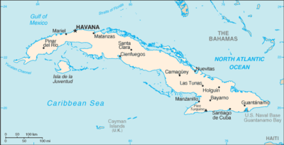
Map of Cuba

Cuba, officially the Republic of Cuba, is an island country in the Caribbean. It is an archipelago of islands located in the northern Caribbean Sea at the confluence with the Gulf of Mexico and the Atlantic Ocean. The United States lies to the northwest, the Bahamas to the north, Haiti to the east, Jamaica and the Cayman Islands to the south, and Mexico to the west. The country is subdivided into 15 provinces and one special municipality (Isla de la Juventud, the country's second largest island). Cuba's capital and largest city is Havana.

Airports

Airport names shown in bold have scheduled passenger service on commercial airlines.

Location served Province ICAO IATA Airport name Coordinates
Public airports
Baracoa Guantánamo MUBA BCA Gustavo Rizo Airport 20°21′55″N 074°30′22″W
Bayamo Granma MUBY BYM Carlos Manuel de Céspedes Airport 20°23′47″N 076°37′17″W
Camagüey Camagüey MUCM CMW Ignacio Agramonte International Airport 21°25′13″N 077°50′51″W
Cayo Coco Ciego de Ávila MUCC CCC Jardines del Rey Airport 22°27′40″N 078°19′43″W
Cayo Largo del Sur Isla de la Juventud MUCL CYO Vilo Acuña Airport (Juan Vitalio Acuña Airport) 21°36′58″N 81°32′44″W
Cayo Santa Maria Villa Clara MUBR BWW Las Brujas Airport 22°37′16″N 079°08′50″W
Ciego de Ávila Ciego de Ávila MUCA AVI Máximo Gómez Airport 22°01′37″N 078°47′22″W
Cienfuegos Cienfuegos MUCF CFG Jaime González Airport 22°09′00″N 080°23′51″W
Florida Camagüey MUFL Florida Airport 21°29′59″N 078°12′10″W
Guantánamo Guantánamo MUGT GAO Mariana Grajales Airport 20°05′07″N 075°09′29″W
Guardalavaca Holguín MUGV Guardalavaca Airport 21°06′40″N 75°49′20″W
Havana Havana MUHA HAV José Martí International Airport 22°59′21″N 082°24′33″W
Havana Artemisa MUPB UPB Playa Baracoa Airport 23°01′58″N 082°34′46″W
Holguín Holguín MUHG HOG Frank País Airport 20°46′44″N 076°18′44″W
Las Tunas Las Tunas MUVT VTU Hermanos Ameijeiras Airport 20°59′16″N 076°56′09″W
Manzanillo Granma MUMZ MZO Sierra Maestra Airport 20°17′20″N 077°05′12″W
Moa Holguín MUMO MOA Orestes Acosta Airport 20°39′14″N 74°55′20″W
Nueva Gerona Isla de la Juventud MUNG GER Rafael Cabrera Airport (Rafael Cabrera Mustelier Airport) 21°50′05″N 082°47′02″W
Nueva Gerona Isla de la Juventud MUSN SZJ Siguanea Airport 21°38′33″N 082°57′18″W
Pinar del Río Pinar del Río MULM LCL La Coloma Airport 22°20′11″N 083°38′32″W
Pinar del Río Pinar del Río MUPR QPD Pinar del Río Airport 22°25′17″N 083°40′42″W
Punta de Maisí Guantánamo MUMA UMA Punta de Maisí Airport 20°14′35″N 74°08′50″W
San Nicolás de Bari Mayabeque MUNB QSN San Nicolás de Bari Airport 22°45′23″N 081°55′15″W
Sancti Spíritus Sancti Spíritus MUSS USS Sancti Spíritus Airport 21°58′12″N 079°26′34″W
Santa Clara Villa Clara MUSC SNU Abel Santamaría Airport 22°29′32″N 079°56′37″W
Santa Lucía Camagüey MUSL Joaquín de Agüero Airport (Santa Lucia Airport) 21°30′34″N 077°01′13″W
Santiago de Cuba Santiago de Cuba MUCU SCU Antonio Maceo Airport 19°58′12″N 075°50′08″W
Trinidad Sancti Spíritus MUTD TND Alberto Delgado Airport 21°47′18″N 79°59′50″W
Varadero Matanzas MUVR VRA Juan Gualberto Gómez Airport 23°02′04″N 81°26′07″W
Varadero Matanzas MUKW Kawama Airport 23°07′25″N 081°18′07″W
Military airports
Guantánamo Bay Guantánamo MUGM NBW Leeward Point Field (Naval Station Guantanamo Bay) 19°54′23″N 075°12′25″W
Havana Havana MUMG Managua Airport 22°58′12″N 82°16′30″W
Havana Havana MULB Ciudad Libertad Airport 23°05′38″N 082°26′17″W
Pinar del Río Pinar del Río MUSJ SNJ San Julian Air Base 22°05′43″N 084°09′07″W
San Antonio de los Baños Artemisa MUSA San Antonio de los Baños Air Base 22°52′18″N 082°30′34″W
Closed airports
Caibarién Villa Clara MUCB Caibarién Airport (abandoned)
Cayo Coco Ciego de Ávila MUOC Cayo Coco Airport (abandoned)
Mariel Artemisa MUML Mariel Airport (abolished)
Mayajigua Sancti Spiritus MJG Mayajigua Airport (abandoned)
Nicaro Holguín MUNC ICR Nicaro Airport (abandoned)
Preston Holguín PST Preston Airport (abandoned)

See also

References

  • (in Spanish) El Instituto de Aeronáutica Civil de Cuba (IACC)
  • "ICAO Location Indicators by State" (PDF). International Civil Aviation Organization. 17 September 2010.
  • "IATA Airline and Airport Code Search". International Air Transport Association.
  • "UN Location Codes: Cuba". UN/LOCODE 2012-1. UNECE. 14 September 2012. - includes IATA codes
  • Great Circle Mapper: Airports in Cuba, reference for airport codes
This article is issued from Wikipedia. The text is licensed under Creative Commons - Attribution - Sharealike. Additional terms may apply for the media files.