List of airports in Anguilla
Anguilla is a British overseas territory in the Caribbean, one of the most northerly of the Leeward Islands in the Lesser Antilles. It consists of the main island of Anguilla itself, approximately 26 km (16 mi) long by 5 km (3.1 mi) wide at its widest point, together with a number of much smaller islands and cays with no permanent population. The island's capital is The Valley.
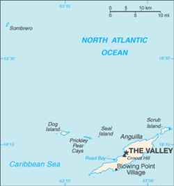
Map of Anguilla
This is a list of airports in Anguilla.
Airports
| Location | ICAO | IATA | Airport name | Coordinates |
|---|---|---|---|---|
| The Valley | TQPF | AXA | Clayton J. Lloyd International Airport | 18°12′17″N 63°03′18″W |
See also
- Transport in Anguilla
- List of airports by ICAO code: T#TQ - Anguilla
- List of airports in the United Kingdom and the British Crown Dependencies
- Wikipedia: WikiProject Aviation/Airline destination lists: North America#Anguilla (United Kingdom)
References
- "ICAO Location Indicators by State" (PDF). International Civil Aviation Organization. 17 September 2010.
- "UN Location Codes: Anguilla". UN/LOCODE 2011-2. UNECE. 28 February 2012. – includes IATA codes
- Great Circle Mapper: Airports in Anguilla – IATA and ICAO codes
- World Aero Data: Anguilla – ICAO codes and coordinates
List of airports in the Americas | ||
|---|---|---|
| ||
| Sovereign states |
| .svg.png) |
| ||
This article is issued from Wikipedia. The text is licensed under Creative Commons - Attribution - Sharealike. Additional terms may apply for the media files.