Pinar del Río
Pinar del Río is the capital city of Pinar del Río Province. With a city population of 139,336 (2004), in a municipality of 190,332, it is the 10th largest city in Cuba. Inhabitants of the area are called Pinareños.
Pinar del Río | |
|---|---|
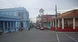 The central avenue "Calle de José Martí" | |
 Coat of arms | |
.png) Pinar del Río municipality (red) within Pinar del Río Province (yellow) and Cuba | |
| Coordinates: 22°24′44″N 83°40′19″W | |
| Country | Cuba |
| Province | Pinar del Río |
| Founded | September 10, 1867 |
| Area | |
| • Municipality | 691.12 km2 (266.84 sq mi) |
| • Urban | 70.7 km2 (27.3 sq mi) |
| Elevation | 61 m (200 ft) |
| Population (2012)[2] | |
| • Municipality | 190,532 |
| • Density | 269.1/km2 (697/sq mi) |
| • Urban | 154,107 |
| • Urban density | 2,200/km2 (5,600/sq mi) |
| Demonym(s) | Pinareños |
| Time zone | UTC-5 (EST) |
| • Summer (DST) | UTC-4 (EDT) |
| Postal code | 20100-20300 |
| Area code(s) | +53 48 |
| Vehicle registration | P |
| Highways | Carretera Central |
History
Pinar del Río was one of the last major cities in Cuba founded by the Spanish September 10, 1867. The city and province was founded as Nueva Filipinas (New Philippines) in regard to influx of Asian laborers coming from the Philippine Islands to work on tobacco plantations.
Pinar del Rio's history begins with the Guanahatabeys, a group of nomadic Indians who lived in caves and procured most of their livelihood from the sea. Less advanced than the other indigenous natives who lived on the island, the Guanahatabey were a peaceful and passive race whose culture more or less independently of the Taino and Siboney cultures further east. Extinct by the time of the Spanish arrived in 1492, little firsthand documentation remains on how the archaic Guanahatabey society was structured and organized although some archeological sites have been found on the Guanahacabibes Peninsula.
Post-Columbus the conquistadors left rugged Pinar del Rio largely to its own devices, and the area developed lackadaisically only after Canary Islanders started arriving in late the 1500s. These Canarians became the tobacco farmers of the region. It was originally called Nueva Filipina (New Philippines), but the region was renamed Pinar del Rio in 1778, supposedly for the pine forests crowded along the Rio Guama. Tobacco plantations and cattle ranches quickly sprang up in the rich soil and open grazing land that typifies Pinar and farmers who made a living from the delicate and well-tended crops were colloquially christened Guajiros, a native word that means - literally - 'one of us '. By the mid 1800s, Europeans were hooked on the fragrant weed and the region flourished. Sea routes opened up and the railways was extended to facilitate the shipping of the perishable product. Pinar del Rio is known to be the Mecca of Tobacco.
Geography
The municipality borders with San Luis, San Juan y Martínez, Viñales and Consolación del Sur. The villages included in the municipality are Briones Montoto, Cayo Conuco,[3] La Coloma, La Conchita and Las Ovas.
Climate
Pinar del Río has a warm tropical climate, more specifically tropical monsoon according to the Köppen climate classification scheme.
| Climate data for Pinar del Río | |||||||||||||
|---|---|---|---|---|---|---|---|---|---|---|---|---|---|
| Month | Jan | Feb | Mar | Apr | May | Jun | Jul | Aug | Sep | Oct | Nov | Dec | Year |
| Average high °C (°F) | 27.0 (80.6) |
27.0 (80.6) |
29.0 (84.2) |
30.0 (86.0) |
31.0 (87.8) |
31.0 (87.8) |
32.0 (89.6) |
32.0 (89.6) |
32.0 (89.6) |
30.0 (86.0) |
29.0 (84.2) |
27.0 (80.6) |
29.8 (85.6) |
| Average low °C (°F) | 17.0 (62.6) |
17.0 (62.6) |
18.0 (64.4) |
20.0 (68.0) |
21.0 (69.8) |
23.0 (73.4) |
23.0 (73.4) |
23.0 (73.4) |
22.0 (71.6) |
21.0 (69.8) |
19.0 (66.2) |
18.0 (64.4) |
20.2 (68.3) |
| Average rainfall mm (inches) | 56.0 (2.20) |
65.0 (2.56) |
74.0 (2.91) |
78.0 (3.07) |
190.0 (7.48) |
260.0 (10.24) |
161.0 (6.34) |
208.0 (8.19) |
221.0 (8.70) |
129.0 (5.08) |
75.0 (2.95) |
40.0 (1.57) |
1,557 (61.29) |
| Average rainy days | 6.0 | 6.0 | 5.0 | 6.0 | 11.0 | 15.0 | 13.0 | 14.0 | 16.0 | 12.0 | 7.0 | 6.0 | 117 |
| Mean monthly sunshine hours | 217.0 | 226.0 | 248.0 | 270.0 | 248.0 | 210.0 | 248.0 | 248.0 | 210.0 | 217.0 | 210.0 | 217.0 | 2,769 |
| Percent possible sunshine | 64 | 73 | 67 | 69 | 62 | 54 | 62 | 62 | 58 | 58 | 64 | 64 | 63 |
| Source: Weather Atlas [4] | |||||||||||||
Economy
The city is located in a major tobacco-growing area and is a centre of the cigar industry. The main farming tool in this province is the carabao.
Demographics
In the 2002 national census, the following statistics were recorded:
- Area: 70.7 km² (city); 708 km² (municipality)
- Population: 189,221 (total); 152,200 (city); 30,417 (surrounding rural area)
- Density: 270,4 /km²
In 2004, the municipality of Pinar del Río had a population of 190,532.[2] With a total area of 708 km2 (273 sq mi),[1] it has a population density of 269.1/km2 (697/sq mi).
Education
The main secondary education institution is the University of Pinar del Río.
Transport
The city is served by the Carretera Central highway and by the A4 motorway. Pinar del Río Airport is abandoned and La Coloma Airport (IATA: LCL, ICAO: MULM) has no scheduled flights. There is a railway station on the line to Havana.
Sport
The local baseball club is Pinar del Río, nicknamed Vegueros, and the association football one is the FC Pinar del Río. Both the clubs have their home ground in the Capitán San Luis Stadium. The "Vegueros" are the Serie del Caribe 2015 champions.
Notable people
- Danys Báez - former Major League Baseball pitcher
- Mario Bencomo - an internationally exhibited painter
- René Capo - Olympic Judoka
- Mijaín López - three-time Olympic Greco-Roman Wrestling Champion
- Yoel Romero - Mixed Martial Artist, Olympic Wrestler
- Willy Chirino - singer-songwriter
- Sen Dog - member of Cypress Hill
- Dagoberto Valdés Hernández - religious leader/writer
- Yunieski Gonzalez - boxer
- Carlos Luna (artist) – Artist
- Yunesky Maya - pitcher for the Washington Nationals
- Polo Montañez - singer and songwriter.
- Pedro Pablo Oliva - painter
- Tony Oliva - former outfielder for the Minnesota Twins
- Rudy Pérez - composer
- Alexei Ramírez - infielder for the Chicago White Sox
- Gonzalo Rubalcaba - pianist
- Eduardo Zamacois - was a Spanish novelist
- Dolan Mor, writer
Gallery
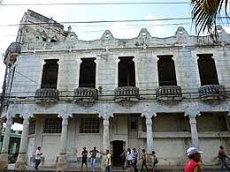 The historical building "Fruti Cuba (Fruit Juices)", located in city centre
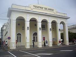 Milanés Theatre
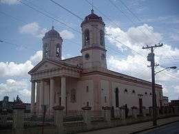 Cathedral
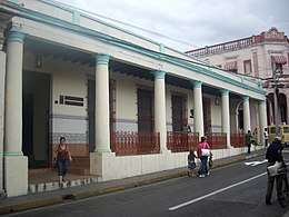 Culture house "Pedro Junco"
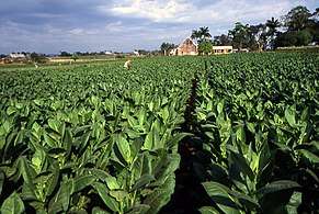 Tobacco plantation
 Cigar factory
See also
- Filipino Cuban
- List of cities in Cuba
- Municipalities of Cuba
References
- Statoids (July 2003). "Municipios of Cuba". Retrieved 2007-10-07.
- Atenas.cu (2004). "2004 Population trends, by Province and Municipality" (in Spanish). Archived from the original on 2007-09-27. Retrieved 2007-10-07.
- "Cayo Conuco (Cuba) map - nona.net". nona.net. Retrieved 2011-02-14.
- "Pinar del Río, Cuba - Monthly weather forecast and Climate data". Weather Atlas. Retrieved 3 July 2019.
External links
| Wikimedia Commons has media related to Pinar del Río. |
- (in Spanish) Pinar del Río.cu
- (in Spanish) Pinar del Río on EcuRed
- (in Spanish) Pinar del Río on guije.com (historical infos)
Places adjacent to Pinar del Río | |
|---|---|
| Current provinces | |||||||
|---|---|---|---|---|---|---|---|
| Current special municipality | |||||||
| Historical provinces |
| ||||||
| Provincial capitals | |||||||
| |||||||