List of airports in the Bahamas

This is a list of airports in the Bahamas, grouped by island and sorted by location.
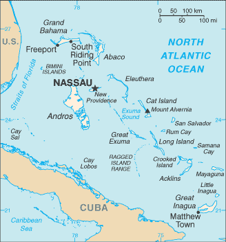
Map of the Bahamas

The Bahamas, officially the Commonwealth of The Bahamas, is an English-speaking country consisting of 29 islands, 661 cays, and 2,387 islets. It is located at the north-east of the Caribbean Sea in the Atlantic Ocean north of Cuba, Hispaniola (Dominican Republic and Haiti) and the Caribbean Sea, northwest of the Turks and Caicos Islands, and southeast of the United States of America (nearest to the state of Florida). Its total land area is almost 14,000 square kilometres (5,400 sq mi), with an estimated population of 330,000. Its capital is Nassau.

Airports

Airport names shown in bold indicate the airport has scheduled service on commercial airlines.

Location served ICAO IATA Airport name Runway (ft) Coordinates
ABACO
Castaway Cay MYAG Castaway Cay Airport (private) 14/32: 3,100 x 80, ASPHALT 26°05′26.0″N 077°32′23.9″W
Marsh Harbour MYAM MHH Marsh Harbour Airport 6,100 x 100[1] 26°30′41.1″N 077°05′00.7″W
Moore's Island MYAO Mores Island Airport 2,640 x 100 26°19′04.5″N 077°33′44.3″W
Sandy Point MYAS Sandy Point Airport 4,500 x 100 26°00′17.0″N 077°23′43.9″W
Scotland Cay MYXI Scotland Cay Airport (private) 13/31: 3,000 x 100, GRAVEL 26°38′31.0″N 077°04′02.9″W
Spanish Cay MYAX Spanish Cay Airport 14/32: 4,402 x 70, GRAVEL 26°57′01.2″N 077°32′37.7″W
Treasure Cay MYAT TCB Treasure Cay Airport 6,900 x 150 26°44′43.2″N 077°23′27.6″W
Walker's Cay MYAW WKR Walker's Cay Airport 09/27: 2,500 x 80, GRAVEL 27°15′37.5″N 078°24′08.0″W
ACKLINS
Spring Point MYAP AXP Spring Point Airport 5,000 x 150 22°26′30.8″N 073°58′14.9″W
ANDROS
Andros Town, North Andros MYAF ASD Andros Town Airport (Fresh Creek Airport) 4,000 x 100 24°41′52.7″N 077°47′44.4″W
Andros Town, North Andros MYCZ Autec Heliport H1: 100 x 100, ASPHALT
H2: 100 x 100, ASPHALT
H3: 100 x 100, ASPHALT
H4: 100 x 100, ASPHALT
24°42′34.2″N 077°46′21.5″W
Andros Town, North Andros Andros Central Airport (closed) 5,000 x 150 24°43′32.8″N 077°59′17.4″W
Congo Town, South Andros MYAK TZN[2] South Andros Airport (Congo Town Airport) 4,300 x 100 24°09′31.5″N 077°35′23.4″W
Mangrove Cay MYAB MAY Clarence A. Bain Airport 5,000 x 75 24°17′15.6″N 077°41′03.9″W
Nicholls Town, North Andros MYAN SAQ San Andros Airport 5,000 x 75 25°03′13.8″N 078°02′57.4″W
BERRY ISLANDS
Big Whale Cay MYBW Big Whale Cay Airport 07/25: 4,000 x 55, ASPHALT 25°24′07.2″N 077°47′18.3″W
Chub Cay MYBC CCZ Chub Cay International Airport 11/29: 5,000 x 78, ASPHALT 25°25′01.8″N 077°52′50.5″W
Cistern Cay MYBT Cistern Field 16/34: 2,250 x 80, ASPHALT 25°46′46.8″N 077°53′08.2″W
Great Harbour Cay MYBG GHC Great Harbour Cay Airport 4,536 x 80 25°44′18.2″N 077°50′25.0″W
Little Whale Cay MYBX Little Whale Cay Airport 08/26: 1,750 x 52, ASPHALT 25°26′58.5″N 077°45′34.2″W
BIMINI
Bimini NSB[2] North Seaplane Base
Bimini MYBS BIM South Bimini Airport 5,600 x 100 25°41′59.9″N 079°15′54.8″W
North Cat Cay MYCC CXY Cat Cay Airport 13/31: 1,100 x 50, ASPHALT 25°33′19.0″N 079°16′33.8″W
Ocean Cay MYBO Ocean Cay Airport 09/27: 1,650 x 92, GRAVEL
17/35: 1,890 x 89, GRAVEL
25°25′22.5″N 079°12′34.1″W
CAT ISLAND
Arthur's Town MYCA ATC Arthur's Town Airport 7,034 x 150 24°37′46.9″N 075°40′27.9″W
Cutlass Bay MYCX Cutlass Bay Airport 11/29: 2,400 x 60, ASPHALT 24°08′56.9″N 075°23′53.0″W
Hawks Nest MYCH Hawks Nest Airport 08/26: 4,600 x 80, ASPHALT 24°09′15.1″N 075°31′13.0″W
New Bight MYCB TBI[2] New Bight Airport 5,065 x 75 24°18′55.1″N 075°27′09.2″W
CAY SAL
Cay Sal MYCS Cay Sal Airport (private) 2,000 x 100 23°41′34.0″N 080°23′15.0″W
CROOKED ISLAND
Colonel Hill MYCI CRI Colonel Hill Airport (Crooked Island Airport) 3,500 x 60 22°44′43.4″N 074°10′57.0″W
Pitts Town MYCP PWN Pitts Town Airport 09/27: 1,960 x 33, ASPHALT 22°49′47.0″N 074°20′47.1″W
ELEUTHERA
Freetown MYEC CEL Cape Eleuthera Airport (closed) 11/29: 6,460 x 144, ASPHALT 24°47′25.2″N 076°17′40.8″W
Governor's Harbour MYEM GHB Governor's Harbour Airport 8,500 x 150 25°17′04.9″N 076°19′51.5″W
North Eleuthera MYEH ELH North Eleuthera Airport 4,500 x 100 25°28′32.2″N 076°40′52.8″W
Rock Sound MYER RSD Rock Sound International Airport 7,200 x 150 24°53′42.1″N 076°10′34.6″W
EXUMA
Black Point MYEB Black Point Airport 12/30: 2,620 x 80, ASPHALT 24°05′21.4″N 076°23′52.5″W
Darby Island Darby Island Airport (private) 1,500 x 100 23°51′04.4″N 076°13′41.1″W
Fowl Cay MYXA Fowl Cay Airport 10/28: 1,040 x 45, ASPHALT 24°16′14.6″N 076°32′27.5″W
Great Exuma Island (George Town) MYEG George Town Airport 11/29: 5,000 x 90, ASPHALT 23°27′59.6″N 075°46′54.2″W
Great Exuma Island (Moss Town) MYEF GGT Exuma International Airport 8,000 x 100 23°33′45.0″N 075°52′39.2″W
Hog Cay MYEY Hog Cay Airport 12/30: 2,530 x 49, ASPHALT 23°23′50.7″N 075°29′49.5″W
Leaf Cay MYXD Leaf Cay Airport 09/27: 1,200 x 40, GRAVEL 24°08′57.9″N 076°28′22.5″W
Lee Stocking Island MYXE/MYEL Lee Stocking Airport 12/30: 3,230 x 141, ASPHALT 23°46′32.1″N 076°06′13.4″W
Little Darby Island MYXF Little Darby Island Airport (private) 14/32: 1,000 x 75, GRASS 23°51′28.5″N 076°13′22.5″W
Little Farmer's Cay Farmers Cay Airport 18/36: 2,480 x 56, ASPHALT 23°57′41.9″N 076°19′34.3″W
Norman's Cay MYEN NMC Norman's Cay Airport 3,360 x 70 24°35′39.5″N 076°49′12.3″W
Rudder Cut Cay Rudder Cut Cay Airport 09/27: 2,150 x 89, GRAVEL 23°53′11.1″N 076°15′10.2″W
Sampson Cay MYXH Sampson Cay Airport (private) 14/32: 2,000 x 39, GRAVEL 24°12′58.6″N 076°28′42.9″W
Staniel Cay MYES TYM Staniel Cay Airport 3,030 x 75 24°10′10.8″N 076°26′21.4″W
GRAND BAHAMA
Deep Water Cay MYGD Deep Water Cay Airport 14/32: 4,200 x 40, GRAVEL 26°37′57.1″N 077°55′19.1″W
Freeport MYGF FPO Grand Bahama International Airport (Freeport Int'l) 11,000 x 150 26°33′31.6″N 078°41′43.6″W
High Rock MYGM Grand Bahama Aux AF Airport 05/23: 7,160 x 197, ASPHALT 26°37′54.6″N 078°21′35.4″W
West End MYGW WTD West End Airport 11/29: 8,000 x 150, ASPHALT 26°41′12.4″N 078°58′44.3″W
INAGUA
Matthew Town MYIG IGA Inagua Airport (Matthew Town Airport) 7,000 x 100 20°58′29.9″N 073°40′00.9″W
LONG ISLAND
Cape Santa Maria MYLM Cape Santa Maria Airport 13/31: 2,600 x 60, GRAVEL 23°38′56.0″N 075°19′24.0″W
Deadman's Cay MYLD LGI Deadman's Cay Airport 4,000 x 80 23°10′43.4″N 075°05′37.2″W
Hog Cay MYXC Hog Cay Airport, Long Island 07/25: 1,800 x 50, ASPHALT 23°36′04.1″N 075°20′20.8″W
Long Island MYLR Hard Bargain Airport 15/33: 3,000 x 60, ASPHALT 23°00′40.3″N 074°54′21.2″W
Stella Maris MYLS SML Stella Maris Airport 3,900 x 90 23°34′58.8″N 075°16′08.4″W
MAYAGUANA
Mayaguana MYMM MYG Mayaguana Airport 7,700 x 150 22°22′50.0″N 073°00′40.1″W
NEW PROVIDENCE
Nassau MYNN NAS Lynden Pindling International Airport 11,000 x 150 25°02′09.8″N 077°28′08.4″W
Paradise Island MYPI PID New Providence Airport (Airstrip closed 1999) 3,000[3]
RAGGED ISLAND
Duncan Town MYRD DCT Duncan Town Airport 3,800 x 75 22°10′54.7″N 075°43′45.6″W
RUM CAY
Port Nelson MYRP RCY Port Nelson Airport 2,400 x 80 23°41′00.4″N 074°50′10.5″W
SAN SALVADOR
Cockburn Town MYSM ZSA San Salvador Airport (Cockburn Town Airport) 8,000 x 180 24°03′47.3″N 074°31′25.0″W

See also

References

  1. "AirNav: MYAM - Leonard M Thompson International Airport". www.airnav.com.
  2. "IATA Airport Code Search". International Air Transport Association. Retrieved May 18, 2016.
  3. Sun-Sentinel, ANN and VINCE MAGNOTTA, Special to the. "NEW PLANES HELP DELIVER VISITORS TO PARADISE ISLAND". Sun-Sentinel.com.


This article is issued from Wikipedia. The text is licensed under Creative Commons - Attribution - Sharealike. Additional terms may apply for the media files.