Santa Clara, Cuba
Santa Clara is the capital city of the Cuban province of Villa Clara. It is located in the most central region of the province and almost in the most central region of the country. With a population near a quarter million, Santa Clara is the 5th largest Cuban city by population.
Santa Clara | |
|---|---|
 Street in Parque Vidal, the heart of Santa Clara city | |
Flag .png) Coat of arms | |
.png) Santa Clara municipality (red) within Province of Las Villas (yellow) and Cuba | |
| Coordinates: 22°24′24.91″N 79°57′53.78″W | |
| Country | Cuba |
| Province | Villa Clara |
| Founded | July 15th, 1689 |
| Established | January 1, 1690[1] |
| Area | |
| • Total | 514 km2 (198 sq mi) |
| Elevation | 125 m (410 ft) |
| Population (2011)[3] | |
| • Total | 242,402 |
| • Density | 470/km2 (1,200/sq mi) |
| Demonym(s) | Santaclareño |
| Time zone | UTC-5 (EST) |
| Postal code | 50100 |
| Area code(s) | +53 422 |
History

Santa Clara was founded by 175 people on July 15, 1689. 138 of them were represented by two large families already living in the area and, therefore, owners of the land next to the new city. The other 37 came from seven other families, and included a priest and a governor, all originating in the coastal city of San Juan de los Remedios (also known as Remedios, Cuba).
The population of Remedios was torn between the option of leaving their city, constantly besieged by pirate attacks, or staying in place. While most finally decided to stay, these 37 persons traveled south to the interior. On June 1, 1689 they arrived at the hill where they joined the other two existing families. According to tradition, a mass was given under a tamarind tree and the city was founded. Since then, the place under the tree is known as Loma Del Carmen (Carmen's Hill). A second-generation church was built in a park along the plaza. A monument commemorating the event is surrounded by a fourth-generation tamarind tree.
At its beginnings, the settlement was called Cayo Nuevo, then Dos Cayos, Villa Nueva de Santa Clara, Pueblo Nuevo de Antón Díaz, Villa Clara, and finally Santa Clara.
Construction of the city began not far from Carmen's Hill. Following the Spanish standards, a perfect squared layout with a central plaza (Plaza Mayor, today known as Parque Vidal) was developed. The first buildings erected were the Cabildo (City Council) and a modest palm tree church. This building was replaced in 1725 with a brick one. It was at the center of the Parque Vidal as Catedral de Santa Clara de Asís until August 22, 1923. It was torn down so that the plaza could be expanded. A new church was built nearby. This decision by the mayor is still criticized nearly a century later. Although the church was not the finest architecture, it was one of the oldest colonial structures in the city and part of its fabric. After the expropriation by the mayor and City Council, religious officials complained and the court awarded 77,850 pesos in fines as a settlement to the Church. It was a considerable sum that would represent millions of pesos today.
Soon after the city was founded, a theater, a chamber of commerce, meeting clubs, public libraries and dance halls were erected as well. Positioned nearly in the center of the country, the city became a popular travelers's stop and a great communication link, both east-west and north-south. These conditions supported its steady growth. By the 19th century, Santa Clara was bigger and more populated than the rest of the towns around, including what was once Remedios. As a necessary stop between Havana and the east of the country, the city gained the title of capital of Las Villas province.
Marta Abreu de Estévez

Two well-known figures are associated with Santa Clara: Marta Abreu de Estévez, a beloved native daughter known as "the Benefactress of the City," and Ernesto Che Guevara, political activist and leader of the Revolution. He is buried here, where he waged the final battle of the revolution that toppled the Fulgencio Batista government in 1958.
Marta Abreu is notable for the numerous projects which she and her family promoted through their philanthropy, intended to enhance the life of all citizens of Santa Clara. Marta Abreu and her husband Luis Estévez, who became the first Vice President of the young republic in 1902, were well-known sympathizers and contributors to the Cuban rebels cause during the War of Cuban Independence against Spain (known in the United States as the Spanish–American War, as the US became involved in supporting some forces seeking independence).
Abreu's legacy built institutions all over the city: an electric plant building, several schools, an asylum, public laundry stations by the Belico River (two still exist, although in poor condition), the fire station a block off the Parque Vidal, and the train station near Carmen's Hill.
The most notable building is the Teatro La Caridad (a theater named in honor of the patron saint of Cuba, La Virgen de la Caridad – Our Lady of Charity). The theater can be admired from one of the corners of the Parque Vidal. Abreu was the project's sole financial sponsor. She personally supervised the design and construction of the theatre. Although it is not as grandiose as the Teatro Tomás Terry in Cienfuegos city, the proceeds of the theater have been designated to support two schools which Abreu founded for poor children of the city. The schools, one for girls and one for boys, were located just behind the theater. La Caridad Theater is one of the seven Big Theaters from the colonial era still standing. It offers exquisite architecture and amazing interior. Abreu also donated her own palace to the city; it was used as a Provincial Government Palace and later adapted for use as a public library. Today, it houses the Biblioteca Martí (Martí Library), also located on the Parque Vidal. It is an example of fine Neo-Classical architecture and has highly decorated interiors. Santa Clara's University is named after Abreu. She is buried in the Colón cemetery of Havana.
Battle of Santa Clara
Santa Clara was the site in late 1958 of the last battle in the Cuban Revolution. Two guerrilla columns attacked the city, one led by Ernesto Che Guevara and the other by Camilo Cienfuegos. Guevara's column first captured the garrison at Fomento. Using a bulldozer, Guevara's soldiers destroyed railroad tracks and derailed a train full of troops and supplies sent by Batista. At the same time, Cienfuegos's column defeated an army garrison at the Battle of Yaguajay not far from town. On December 31, 1958, the combined forces of Guevara and Cienfuegos (along with other revolutionaries under William Alexander Morgan) attacked Santa Clara. The battle was chaotic, the defenders were demoralized, some fought, others surrendered without a shot. By the afternoon, the city was captured. This victory for Castro's troops is seen as the decisive moment in the Cuban Revolution, as Batista fled Cuba less than 12 hours later.
Geography
Located on a plain below a hillside, in the middle of its province, Santa Clara is 71.5 km far from the Caribbean Sea (at Cienfuegos) and 51.7 km from the Atlantic Ocean (at Caibarién). The municipality borders with the municipalities of Cifuentes, Camajuaní, Placetas, Manicaragua and Ranchuelo.[4][5]
The city is divided into several wards (Repartos):
- America Latina
- Antón Díaz
- Bengochea
- Brisas del Capiro
- Camacho
- Capiro
- Cardoso
- Centro
- Chambéry
- Domínguez
- El Carmen
- El Gigante
- El Vaquerito (Puerto Escondido)
- Escambray
- Escambray Este
- Escambray Norte
- José Martí
- Las Minas
- Los Sirios
- Moro
- Osvaldo Herrera (Dobarganes)
- Páez
- Raúl Sancho (Condado)
- San Daniel
- Sandino
- Santa Catalina
- Sub Planta
- Tenería
- Tirzo Díaz
- Universidad
- Vigía
- Vigía Sur
- Villa Josefa
- Virginia
Climate
| Climate data for Santa Clara | |||||||||||||
|---|---|---|---|---|---|---|---|---|---|---|---|---|---|
| Month | Jan | Feb | Mar | Apr | May | Jun | Jul | Aug | Sep | Oct | Nov | Dec | Year |
| Average high °C (°F) | 27 (81) |
28 (82) |
29 (84) |
29 (85) |
31 (87) |
32 (89) |
32 (90) |
32 (90) |
32 (89) |
31 (88) |
28 (83) |
28 (82) |
30 (86) |
| Average low °C (°F) | 17 (63) |
17 (62) |
18 (64) |
19 (67) |
21 (69) |
22 (71) |
22 (72) |
22 (72) |
22 (71) |
22 (71) |
19 (67) |
18 (64) |
20 (68) |
| Average precipitation mm (inches) | 18 (0.7) |
25 (1) |
33 (1.3) |
46 (1.8) |
120 (4.7) |
150 (6) |
120 (4.8) |
160 (6.3) |
170 (6.8) |
160 (6.3) |
41 (1.6) |
23 (0.9) |
1,070 (42.2) |
| Source: Weatherbase [6] | |||||||||||||
Demographics
In 2004, the municipality of Santa Clara had a population of 237,581.[3] With a total area of 514 km2 (198 sq mi),[2] it has a population density of 462.2/km2 (1,197/sq mi).
Attractions
_in_Santa_Clara_city%2C_Cuba_-2012.jpg)
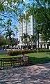
In Santa Clara's center is a park (Parque Vidal) and it is laid on an entire square block. In the park there is a statue of Marta Abreu, a person much loved by the people of Santa Clara. Bordering the park is the Santa Clara Libre (formerly the Santa Clara Hilton), "Gran Hotel", Teatro de La Caridad (a National Monument of Cuba.[7]), the Plaza del Mercado Central, the former City Hall and the Colonia Española de Santa Clara center of dance, offers the most attractive and unique traditional customs of hinterland Cuba.
Parque Vidal is probably one of the most typical places in Cuba. During the afternoons, people (especially singles) visit the park to meet others. Although not widely practiced in recent times, the custom was to walk the park around and around. The women walk the inner part of the park, while the men walk the outer side. Another lost custom was for the locals to set up a platform and offer improvisations with their guitars on late Sunday afternoons. For that day they dressed with their Guayaberas and highly polished shoes.
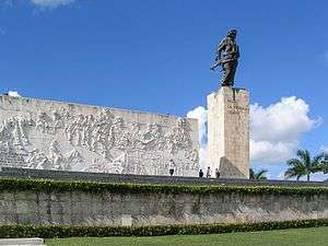
Santa Clara is home to a mausoleum which houses the remains of Che Guevara and sixteen of his fellow combatants killed in 1967 during the Bolivia campaign. There is also a reconstruction of Guevara derailing the train during the Battle of Santa Clara.
Prior to 1 January 1977, Santa Clara was located in Las Villas Province. On that date, as part of a general administrating reordering of Cuba's provinces, Las Villas province was reordered into the provinces of Villa Clara, Cienfuegos, and Sancti Spíritus. Santa Clara is in the province now known as Villa Clara.
Other local landmarks include:
- Parque del Carmen (Carmen's Park)– City's Foundation Site.
- Parque de los Martires (Martyrs' Park).
- Parque de la Pastora (Our Lady Shepherdess Park).
- Parque de la Justicia (Justice's Park).
- Parque del Tren Blindado (The Armored Train Park-Museum), a National Monument of Cuba.[7]
- Mausoleo Che Guevara (Monument and Mausoleum of Ernesto "Che" Guevara).
- Catedral de Santa Clara de Asís (Saint Claire of Asis Cathedral).
- Boulevard 1889.
- Centro Cultural El Mejunje (Cultural Centre "El Mejunje").
- Loma del Capiro, hill overlooking the city
- Villa Clara Provincial Museum, with a collection of art, social and natural history.
- University "Marta Abreu" of Las Villas is the province's secondary education institution.
Transport
.jpg)
Santa Clara is crossed by the Carretera Central highway (CC) and by the A1 motorway. A ring road serving the city is directly linked to the motorway. Its main railway station is part of the principal line of the country, the Havana-Santa Clara-Camagüey-Santiago. "Abel Santamaría", located 11 km in the north, is the city airport, serving flights to the United States, Italy, Canada, France and Poland along with domestic flights among others.
Education
Santa Clara is home to the University "Marta Abreu" of Las Villas (Spanish: Universidad Central "Marta Abreu" de Las Villas (UCLV)), composed of a conglomerate of faculties:
- Electrical Engineering
- Agricultural Sciences
- Mathematics, Physics, and Computer Sciences
- Humanities
- Law
- Psychology
- Social Sciences
- Construction
- Managerial Sciences
- Mechanical Engineering
- Chemistry and Pharmacy
- Distance Education
Offering Bachelor's, Master's, and Doctoral degrees and boasting the graduation of 35000 engineers, licensees, architects, medics, and veterinarians, of which 1000 have been foreigners from 47 countries. Additionally, it has formed more than 310 doctors and more than 1600 magisters. In addition it collaborates with institutions from Germany, Argentina, Belgium, Brazil, Canada, Colombia, France, Spain, Peru, Mexico and Venezuela.
Notable people
- Marta Abreu (1845−1909), benefactress
- José Bernal, artist
- Yuniesky Betancourt, Major League Baseball shortstop
- Mike Cuellar, Major League Baseball pitcher
- Aledmys Díaz, Major League Baseball shortstop
- Newton Estape Vila, photographer and journalist
- José Fernández (1992−2016), Major League Baseball pitcher
- Mirka Francia, Cuban-Italian volleyball player
- Rubén González, pianist
- Benny 'Kid' Paret (1937−1962), boxer
- Moraima Secada, singer
- Miguel Díaz-Canel, Cuba's current President
- Gerardo Machado y Morales, General, President of the Republic (1925-1933)
International relations
Twin towns — Sister cities
Santa Clara is twinned with:


Image gallery
 Santa Clara Libre hotel across Vidal square was during the 1950s and 1960s the tallest building outside Havana
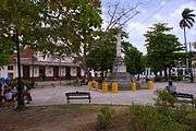 Marta Abreu train station across Martyrs' Park in Santa Clara, Cuba. At the center the truncated pillar monument dedicated to the Martyrs of the Colonial Independence War. Photo from 2010
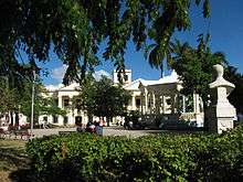 Vidal Park in Santa Clara's downtown.
 Che Guevara's Monument and museum.
 Carmen Church the oldest one in city and point of origin of it.
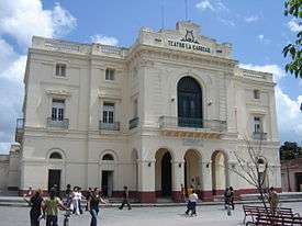 Teatro La Caridad.
Further reading
- Luis Garcia Gonzales: Al pie del Tamarindo. Coleccion Escambray, Santa Clara, 1993, Publicigraf
References
- Guije.com. "Santa Clara" (in Spanish). Retrieved 2007-10-09.
- Statoids (July 2003). "Municipios of Cuba". Retrieved 2007-10-09.
- Atenas.cu (2004). "2004 Population trends, by Province and Municipality" (in Spanish). Archived from the original on 2007-09-27. Retrieved 2007-10-09.
- 5884803 Santa Clara on OpenStreetMap
- Source: Map of Santa Clara with municipal borders (Bing Maps)
- "Weatherbase: Historical Weather for Santa Clara, Cuba". Weatherbase. 2011. Retrieved on November 24, 2011.
- National Council for Cultural Heritage. "National Monuments in Cuba" (in Spanish). Archived from the original on 2007-12-11. Retrieved 2007-10-09.
- Sister cities of Bloomington Archived 2012-09-16 at the Wayback Machine
External links
| Wikimedia Commons has media related to Santa Clara, Cuba. |
| Wikivoyage has a travel guide for Santa Clara. |
- "Santa Clara" Collection of photos from Santa Clara 2007 to 2015
- "Santa Clara's Rebel Saint" by Egle Procuta, Globe and Mail, November 11, 2006
- "Che's Last Stand" by Ed Ewing, The Guardian, December 31, 2008
- Santa Clara a Jump-Off Spot to Twin-isle Paradise by Joseph Kula, The Province, November 10, 2008
- "Travel to Santa Clara" Casa particular in Santa Clara
- "Hostal Florida Center" Colonial Casa Particular in Santa Clara
Places adjacent to Santa Clara, Cuba | ||||||||||
|---|---|---|---|---|---|---|---|---|---|---|
| ||||||||||
| Current provinces | |||||||
|---|---|---|---|---|---|---|---|
| Current special municipality | |||||||
| Historical provinces |
| ||||||
| Provincial capitals | |||||||
| |||||||