List of airports in Bangladesh
This is a list of airports in Bangladesh, grouped by type and sorted by location. All airports are operated and maintained by the Civil Aviation Authority of Bangladesh under the Ministry of Civil Aviation and Tourism. Few of the airfield used for military and training purposes by the Bangladesh Armed Forces.

Bangladesh, officially the People's Republic of Bangladesh, is a country in South Asia. It is bordered by India on all sides except for a small border with Myanmar (Burma) to the far southeast and by the Bay of Bengal to the south. Its capital and largest city is Dhaka.
Bangladesh has 5 domestic airports, 3 international airports (which are also used for domestic flights) and 5 STOL (Short Take-off and Landing) ports, with one new domestic airport under construction.[1] It also has several airstrips, some built during World War II.
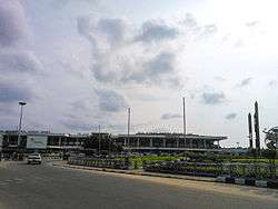
Gallery
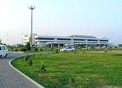

%2C_Bangladesh.JPG)
.jpg)
Contents
| Category | Description |
|---|---|
| Domestic | Handles domestic flights |
| Future | Proposed or under construction |
| International | Handles international flights |
| STOLport | Short take off and landing airports |
| Military | Military airbase |
| Unused | Unused airport |
| Role | Description |
|---|---|
| Closed | No longer in operation for commercial flights |
| Commercial | Handles commercial flights |
| Flying school | Airport used to train commercial and/or fighter pilots |
| Commercial service | Airport has commercial service |
| Airport has no commercial service |
List of airports
- All airports are listed by division. No airports are available in the Mymensingh Division.
Barisal Division
| Location served | Airport name | ICAO | IATA | Category | Role | Coordinates |
|---|---|---|---|---|---|---|
| Barisal | Barisal Airport | VGBR | BZL | Domestic | Commercial | 22°48′04″N 90°18′04″E |
| Patuakhali | Patuakhali Airport | — | — | Unused | Closed | 22°22′33″N 90°19′20″E |
Chittagong Division
| Location served | Airport name | ICAO | IATA | Category | Role | Coordinates |
|---|---|---|---|---|---|---|
| Chittagong | Shah Amanat International Airport | VGEG | CGP | International | Commercial | 22°14′59″N 91°48′48″E |
| Cox's Bazar | Cox's Bazar Airport | VGCB | CXB | Domestic | Commercial | 21°27′07″N 91°57′50″E |
| Chittagong | Zahurul Haq Airbase | — | — | Military | Active | 22°15′39″N 91°49′05″E |
| Comilla | Comilla Airport | VGCM | CLA | STOLport | No scheduled flights | 23°26′12″N 91°11′24″E |
| Noakhali | Noakhali Air Field | — | — | Future | Under construction | 22°44′21″N 91°03′54″E |
| Dohazari | Dohazari Airfield | — | — | Military | Closed | 22°09′55″N 92°04′07″E |
| Chakaria | Chakaria Airport | — | — | 21°45′49″N 92°04′18″E | ||
| Feni | Fenny Airfield | — | — | 23°02′06″N 91°23′37″E | ||
| Hathazari | Hathazari Airfield | — | — | 22°30′02″N 91°48′27″E |
Dhaka Division
| Location served | Airport name | ICAO | IATA | Category | Role | Coordinates |
|---|---|---|---|---|---|---|
| Dhaka | Shahjalal International Airport | VGHS | DAC | International | Commercial | 23°50′34″N 90°24′02″E |
| Tejgaon | Khademul Bashar Airbase | VGTJ | — | Military | Airbase | 23°46′43″N 90°22′57″E |
| Bajitpur | Bajitpur Airport | — | — | Unused | Closed | 24°12′44″N 90°54′23″E |
| Tangail | Tangail Airport | — | — | 24°13′47″N 89°54′28″E |
Khulna Division
| Location served | Airport name | ICAO | IATA | Category | Role | Coordinates |
|---|---|---|---|---|---|---|
| Bagerhat | Khan Jahan Ali Airport | — | — | Future | Under construction | 22°38′49″N 89°38′38″E |
| Jessore | Jessore Airport | VGJR | JSR | Domestic | Commercial | 23°11′01″N 89°09′39″E |
| Jessore | Matiur Rahman Airbase | — | — | Military | Airbase | 23°10′40″N 89°09′40″E |
Rajshahi Division
| Location served | Airport name | ICAO | IATA | Category | Role | Coordinates |
|---|---|---|---|---|---|---|
| Ishwardi | Ishwardi Airport | VGIS | IRD | STOLport | No scheduled flights | 24°09′11″N 89°02′55″E |
| Rajshahi | Shah Makhdum Airport | VGRJ | RJH | Domestic | Commercial | 24°26′13″N 88°36′59″E |
| Bogra | Bogra Airport | VGBG | — | Military | Airbase | 24°52′00″N 89°18′59″E |
| Sirajganj | Sirajganj Airport | — | — | Unused | Closed | 25°16′59″N 91°42′50″E |
Rangpur Division
| Location served | Airport name | ICAO | IATA | Category | Role | Coordinates |
|---|---|---|---|---|---|---|
| Saidpur | Saidpur Airport | VGSD | SPD | Domestic | Commercial | 25°45′33″N 88°54′31″E |
| Lalmonirhat | Lalmonirhat Airport | VGLM | — | STOLport | No scheduled flights | 25°53′15″N 89°25′59″E |
| Thakurgaon | Thakurgaon Airport | VGSG | TKR | STOLport | No scheduled flights | 26°00′59″N 88°24′06″E |
Sylhet Division
| Location served | Airport name | ICAO | IATA | Category | Role | Coordinates |
|---|---|---|---|---|---|---|
| Sylhet | Osmani International Airport | VGSY | ZYL | International | Commercial | 24°57′48″N 91°52′01″E |
| Kamalganj | Shamshernagar Airport | VGSH | ZHM | STOLport | No scheduled flights | 24°23′54″N 91°55′01″E |
See also
References
- "Airports in Bangladesh". Civil Aviation Authority of Bangladesh. Archived from the original on 2007-09-29. Retrieved 2007-01-22.
- "ICAO Location Indicators by State" (PDF). International Civil Aviation Organization. 17 September 2010.
- "UN Location Codes: Bangladesh". UN/LOCODE 2011-2. UNECE. 28 February 2012. - includes IATA codes
- World Aero Data: Bangladesh = ICAO codes
- Great Circle Mapper: Airports in Bangladesh - IATA and ICAO codes
- FallingRain: Airports in Bangladesh
External links
List of airports in Asia | |
|---|---|
| Sovereign states |
|
| States with limited recognition |
|
| Dependencies and other territories |
|
| |