Le Plessis-l'Échelle
Le Plessis-l'Échelle is a commune in the Loir-et-Cher department of central France.
Le Plessis-l'Échelle | |
|---|---|
Location of Le Plessis-l'Échelle 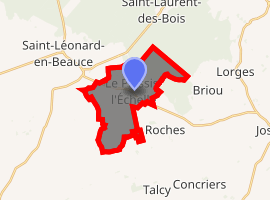
| |
 Le Plessis-l'Échelle  Le Plessis-l'Échelle | |
| Coordinates: 47°48′52″N 1°25′48″E | |
| Country | France |
| Region | Centre-Val de Loire |
| Department | Loir-et-Cher |
| Arrondissement | Blois |
| Canton | La Beauce |
| Intercommunality | Beauce et Forêt |
| Government | |
| • Mayor (2014–2020) | Jean-Luc Dumoulin |
| Area 1 | 11.7 km2 (4.5 sq mi) |
| Population (2017-01-01)[1] | 70 |
| • Density | 6.0/km2 (15/sq mi) |
| Time zone | UTC+01:00 (CET) |
| • Summer (DST) | UTC+02:00 (CEST) |
| INSEE/Postal code | 41178 /41370 |
| Elevation | 111–147 m (364–482 ft) (avg. 120 m or 390 ft) |
| 1 French Land Register data, which excludes lakes, ponds, glaciers > 1 km2 (0.386 sq mi or 247 acres) and river estuaries. | |
Population
| Historical population | ||
|---|---|---|
| Year | Pop. | ±% |
| 1793 | 155 | — |
| 1806 | 154 | −0.6% |
| 1821 | 170 | +10.4% |
| 1831 | 154 | −9.4% |
| 1841 | 173 | +12.3% |
| 1851 | 213 | +23.1% |
| 1861 | 228 | +7.0% |
| 1872 | 265 | +16.2% |
| 1881 | 237 | −10.6% |
| 1891 | 206 | −13.1% |
| 1901 | 190 | −7.8% |
| 1911 | 177 | −6.8% |
| 1921 | 142 | −19.8% |
| 1931 | 140 | −1.4% |
| 1946 | 147 | +5.0% |
| 1954 | 133 | −9.5% |
| 1962 | 126 | −5.3% |
| 1968 | 113 | −10.3% |
| 1975 | 81 | −28.3% |
| 1982 | 67 | −17.3% |
| 1990 | 63 | −6.0% |
| 1999 | 65 | +3.2% |
| 2004 | 68 | +4.6% |
| 2014 | 75 | +10.3% |
References
- "Populations légales 2017". INSEE. Retrieved 6 January 2020.
| Wikimedia Commons has media related to Le Plessis-l'Échelle. |
| Authority control |
|
|---|
This article is issued from Wikipedia. The text is licensed under Creative Commons - Attribution - Sharealike. Additional terms may apply for the media files.