Kotor Varoš
Kotor Varoš or Kotor-Varoš (Serbian Cyrillic: Котор Варош) is a town and municipality located in north-western Republika Srpska, an entity of Bosnia and Herzegovina. As of 2013 census, it has a population of 19,710 inhabitants, while the town of Kotor Varoš has a population of 7,330 inhabitants.
Kotor Varoš Котор Варош | |
|---|---|
Town and municipality | |
 Kotor Varoš | |
.svg.png) Coat of arms | |
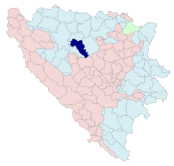 Location of Kotor Varoš within Republika Srpska | |
 | |
| Coordinates: 44°37′20″N 17°22′13″E | |
| Country | Bosnia and Herzegovina |
| Entity | Republika Srpska |
| Government | |
| • Mayor | Zdenko Sakan (Savez za promjene) [1] |
| • Municipality | 544.26 km2 (210.14 sq mi) |
| Population (2013 census) | |
| • Town | 8,360 |
| • Municipality | 19,710 |
| • Municipality density | 36/km2 (94/sq mi) |
| Time zone | UTC+1 (CET) |
| • Summer (DST) | UTC+2 (CEST) |
| Area code(s) | 51 |
History
An early Christian (3rd–5th c.) basilica was discovered along with other Roman findings in the Šiprage area at the Crkvenica-Vrbanja river mouth. 12th-century stećci testify medieval settlement.[2][3] The original location of stećci was the Crkvenica-Vrbanja, from where they were removed and built into walls of the surrounding buildings (possibly due to the beliefs of their miraculous properties).[2] One of the best preserved stećak is submerged in Vrbanja.
It has been theorized that Kotor Varoš was mentioned in the De Administrando Imperio as "Katera" (Greek: Κατερα),[4][5] a part of the "land of Bosnia".[6]
The town was part of the Donji Kraji province of the Banate of Bosnia in the 13th century. In the 14th century, the town was the property of the Hrvatinić noble family.
Austro-Hungarian rule in Bosnia and Herzegovina began in 1878 and ended with the establishment of the Kingdom of Serbs, Croats and Slovenes in 1918, later renamed Kingdom of Yugoslavia. The town was part of the Vrbas Banovina (1929–41), while after World War II it became part of the Socialist Republic of Bosnia and Herzegovina, a republic of Yugoslavia.
During the Bosnian War (1992–95), some religious and cultural monuments and landmarks were destroyed by Serb paramilitary groups, such as a Catholic church in the centre of the town, as well as all of the mosques. In the southern Čaršija (bazaar) quarter of the town nearly all houses were destroyed. Bosnian Serb-dominated parts of the town were largely unaffected. Bosnian Serb police and military forces devastated surrounding villages too, especially those upstream along the Vrbanja to Kruševo Brdo, as well as all non-Serb villages downstream to Banja Luka. All settlements in the Vrbanja valley were sacked and much of the Bosniak and Croat population left the municipality.[7][8]
Settlements
Aside from the town of Kotor Varoš, the municipality includes the following settlements:
- Baština
- Bilice
- Boljanići
- Borci Donji
- Borci Gornji
- Ćorkovići
- Duratovci
- Garići
- Grabovica
- Hadrovci
- Hrvaćani
- Hanifići
- Jakotina
- Kruševo Brdo
- Liplje
- Maljeva
- Maslovare
- Obodnik
- Orahova
- Palivuk
- Plitska
- Podbrđe
- Podosoje
- Postoje
- Prisočka
- Radohova
- Ravne
- Selačka
- Sokoline
- Stopan
- Šibovi
- Šiprage
- Tovladić
- Vagani
- Varjače
- Večići
- Viševice
- Vranić
- Vrbanjci
- Zabrđe
- Zaselje
Demographics
Population
| Population of settlemets – Kotor Varoš municipality | ||||||||||||
|---|---|---|---|---|---|---|---|---|---|---|---|---|
| Settlement | 1895. | 1910. | 1921. | 1931. | 1948. | 1953. | 1961. | 1971. | 1981. | 1991. | 2013. | |
| Total | 20,858 | 23,780 | 22,072 | 27,236 | 22,198 | 37,898 | 32,516 | 32,832 | 35,713 | 36,653 | 19,710 | |
| 1 | Borci Donji | 419 | 255 | |||||||||
| 2 | Garići | 1,341 | 498 | |||||||||
| 3 | Grabovica | 887 | 345 | |||||||||
| 4 | Hrvaćani | 745 | 248 | |||||||||
| 5 | Kotor Varoš | 312 | 1,361 | 1,428 | 1,400 | 2,428 | 4,715 | 2,893 | 3,746 | 5,423 | 7,411 | 7,330 |
| 6 | Liplje | 744 | 271 | |||||||||
| 7 | Maljeva | 595 | 200 | |||||||||
| 8 | Maslovare | 2,284 | 1,930 | |||||||||
| 9 | Obodnik | 842 | 650 | |||||||||
| 10 | Prisočka | 1,423 | 208 | |||||||||
| 11 | Radohova | 700 | 236 | |||||||||
| 12 | Šibovi | 671 | 230 | |||||||||
| 13 | Šiprage | 952 | 652 | |||||||||
| 14 | Večići | 1,744 | 608 | |||||||||
| 15 | Vrbanjci | 2,975 | 1,902 | |||||||||
| 16 | Zabrđe | 1,154 | 482 | |||||||||
Ethnic composition
| Ethnic composition – Kotor Varoš town | |||||||
|---|---|---|---|---|---|---|---|
| 2013. | 1991. | 1981. | 1971. | ||||
| Total | 7,330 (100,0%) | 7,411 (100,0%) | 5,423 (100,0%) | 3,746 (100,0%) | |||
| Serbs | 6,251 (82,22%) | 2,522 (34,03%) | 1,310 (24,16%) | 749 (19,99%) | |||
| Bosniaks | 920 (12,10%) | 1,800 (24,29%) | 1,436 (26,48%) | 1,342 (35,82%) | |||
| Croats | 252 (3,314%) | 2,432 (32,82%) | 1,789 (32,99%) | 1,490 (39,78%) | |||
| Others | 180 (2,367%) | 110 (1,484%) | 66 (1,217%) | 8 (0,214%) | |||
| Yugoslavs | 547 (7,381%) | 787 (14,51%) | 110 (2,936%) | ||||
| Montenegrins | 19 (0,350%) | 40 (1,068%) | |||||
| Albanians | 13 (0,240%) | 3 (0,080%) | |||||
| Macedonians | 2 (0,037%) | ||||||
| Slovenes | 1 (0,018%) | 4 (0,107%) | |||||
| Ethnic composition – Kotor Varoš municipality | |||||||
|---|---|---|---|---|---|---|---|
| 2013. | 1991. | 1981. | 1971. | ||||
| Total | 19,710 (100,0%) | 36,853 (100,0%) | 35,713 (100,0%) | 32,832 (100,0%) | |||
| Serbs | 13,091 (66,42%) | 14,056 (38,14%) | 14,771 (41,36%) | 15,255 (46,46%) | |||
| Bosniaks | 5,241 (26,59%) | 11,090 (30,09%) | 9,667 (27,07%) | 8,366 (25,48%) | |||
| Croats | 1,116 (5,662%) | 10,695 (29,02%) | 9,572 (26,80%) | 8,863 (27,00%) | |||
| Others | 262 (1,329%) | 267 (0,725%) | 349 (0,977%) | 79 (0,241%) | |||
| Yugoslavs | 745 (2,022%) | 1,298 (3,635%) | 176 (0,536%) | ||||
| Montenegrins | 37 (0,104%) | 76 (0,231%) | |||||
| Albanians | 13 (0,036%) | 5 (0,015%) | |||||
| Macedonians | 3 (0,008%) | 2 (0,006%) | |||||
| Slovenes | 3 (0,008%) | 10 (0,030%) | |||||
Economy
The following table gives a preview of total number of registered employed people per their core activity (as of 2016):[11]
| Activity | Total |
|---|---|
| Agriculture, forestry and fishing | 300 |
| Mining and quarrying | 2 |
| Manufacturing | 2,998 |
| Distribution of power, gas, steam and air-conditioning | 45 |
| Distribution of water and water waste management | 43 |
| Construction | 84 |
| Wholesale and retail, repair | 342 |
| Transportation and storage | 126 |
| Hotels and restaurants | 112 |
| Information and communication | 24 |
| Finance and insurance | 25 |
| Real estate activities | 5 |
| Professional, scientific and technical activities | 27 |
| Administrative and support services | 91 |
| Public administration and defence | 193 |
| Education | 316 |
| Healthcare and social work | 115 |
| Art, entertainment and recreation | 7 |
| Other service activities | 55 |
| Total | 4,910 |
Famous people
- Croatian footballer Mateo Kovacic's parents are from here
Features
The city also features a large monument to the local partisans who died for Yugoslavia during the fighting with the German and Ustaša forces during WW2.
Sister cities
Gallery
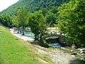 Swimming dam on the Bobas, a popular attraction
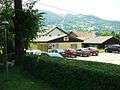 Red Cross building in Kotor Varoš
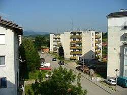
- "Kocke" apartment blocks in town
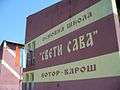 Elementary school "Sveti Sava" (formerly "Bratstvo i jedinstvo")
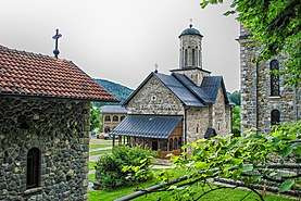
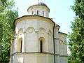 Orthodox church in Kotor Varoš
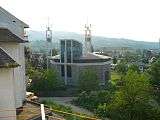 Catholic church in Kotor Varoš, rebuilt
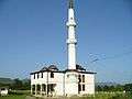 One of two mosques in Kotor Varoš
 Old marketplace, čaršija, shops on left side
References
- http://opstinakotorvaros.com/%D0%BD%D0%B0%D1%87%D0%B5%D0%BB%D0%BD%D0%B8%D0%BA-%D0%BE%D0%BF%D1%88%D1%82%D0%B8%D0%BD%D0%B5/%D0%BD%D0%B0%D1%87%D0%B5%D0%BB%D0%BD%D0%B8%D0%BA-%D0%BE%D0%BF%D1%88%D1%82%D0%B8%D0%BD%D0%B5-2/
- Radimsky V. (1892): Ostanci rimskih naseobina u Šipragi i Podbrgju, za tim starobosanski stećci u Šipragi i uz Vrbanju u Bosni. Glasnik Zemaljskog muzeja u Sarajevu, Godina IV, Knjiga I: 75–80.
- Richter E. (1905): II. Historička i politička geografija. Glasnik Zemaljskog muzeja u Sarajevu, Godina XVI, Knjiga 1: 275–321.
- Марко Атлагић; Branislav Milutinović (2002). Извори за историју Срба до XV века. Филозофски факултет.
Шафарик претпоставл>а да је Катера Которско име у Босни, док С. Новаковић се колеба између два решен>а: Котор у Сарајевскод области или Котор на Врбан>и-притоци Врбаса. М. Прелог тражи Котор на југоисточнод ивици ...
- Zarij M. Bešić (1967). Istorija Crne Gore: od najstarijih vremena do kraja XII vijeka. Pedakt︠s︡ija za istoriju t︠s︡rne gore.
У нащубл>ем неточном краку унутрапньег залива Боке Ко- торске подигнут je град Котор,58 уюпцештен измену ... та Дехатера, за разлику од Котора (Катера) у Босни. Барски родослов има све облике имена Котор: Decatarum, ...
- Constantine VII Porphyrogenitus (1993) [1967]. De Administrando Imperio (Moravcsik, Gyula ed.). Washington D.C.: Dumbarton Oaks Center for Byzantine Studies. pp. 153–155.
- "KOTOR VAROŠ: ZLOČIN PO ZLOČIN – GENOCID".
- Tribunal international chargé de poursuivre les personnes présumées responsables de violations graves du droit international humanitaire commises sur le territoire de l’ex-Yougoslavie depuis 1991, Jugement rendu le: 27 septembre 2006: LE PROCUREUR c/ MOMČILO KRAJIŠNIK.
- Book: "Nacionalni sastav stanovništva – Rezultati za Republiku po opštinama i naseljenim mjestima 1991.", Statistički bilten No 234, Izdanje Državnog zavoda za statistiku Republike Bosne i Hercegovine, Sarajevo.
- Internet – Source: "Popis po mjesnim zajednicama" – "Archived copy" (PDF). Archived from the original (PDF) on 5 October 2013. Retrieved 26 March 2013.CS1 maint: archived copy as title (link)
- "Cities and Municipalities of Republika Srpska 2017" (PDF). rzs.rs.ba (in Serbian). December 2017. Retrieved 20 October 2018.
Sources
| Wikimedia Commons has media related to Kotor Varoš. |
- Vojnogeografski institut, Izd. (1955): Prnjavor (List karte 1:100.000, Izohipse na 20 m). Vojnogeografski institut, Beograd.
- Spahić M. et al. (2000): Bosna i Hercegovina (1:250.000). Izdavačko preduzeće "Sejtarija", Sarajevo.
- Mučibabić B., Ur. (1998): Geografski atlas Bosne i Hercegovine. Geodetski zavod BiH, Sarajevo.