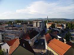
Bihać
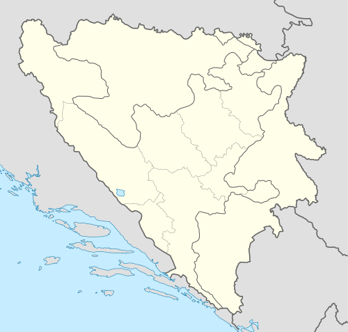
Bihać is a city and the administrative center of Una-Sana Canton of the Federation of Bosnia and Herzegovina, an entity of Bosnia and Herzegovina. It is situated on the banks of river Una in northwestern Bosnia and Herzegovina, in the Bosanska Krajina region. As of 2013, it has a population of 56,261 inhabitants.
Bihać | |
|---|---|
| Grad Bihać City of Bihać | |
.jpg) | |
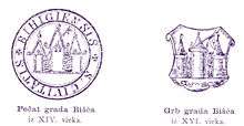
 Coat of arms | |
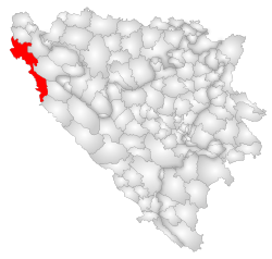 Location of Bihać within Bosnia and Herzegovina. | |
 Bihać Location in Bosnia and Herzegovina | |
| Coordinates: 44°49′N 15°52′E | |
| Country | |
| Political divisions of Bosnia and Herzegovina | Federation of Bosnia and Herzegovina |
| Canton | Una-Sana Canton |
| Government | |
| • Mayor | Šuhret Fazlić (Ind.) |
| Area | |
| • City | 900 km2 (300 sq mi) |
| • Urban | 163 km2 (63 sq mi) |
| Elevation | 230 m (750 ft) |
| Population (2013 census)[1] | |
| • City | 43,007 |
| • Density | 62.51/km2 (161.9/sq mi) |
| • Urban | 56,261 |
| Time zone | UTC+1 (CET) |
| • Summer (DST) | UTC+2 (CEST) |
| ZIP code | 77000 |
| Area code(s) | +387 37 |
| Climate | Cfb |
| Website | www |
Settlements
- Bajrići
- Brekovica
- Bugar
- Ćukovi
- Doljani
- Donja Gata
- Dubovsko
- Gorjevac
- Grabež
- Grmuša
- Hrgar
- Izačić
- Jezero
- Kalati
- Kulen Vakuf
- Lohovo
- Lohovska Brda
- Mala Peća
- Mali Skočaj
- Međudražje
- Muslići
- Ostrovica
- Papari
- Praščijak
- Pritoka
- Račić
- Rajinovci
- Ripač
- Spahići
- Srbljani
- Velika Gata
- Veliki Skočaj
- Veliki Stjenjani
- Vikići
- Vrsta
- Zavalje i Zlopoljac
History
Bihać was mentioned for the first time in the year 1290.[2]
In the late Middle Ages, Bihać was a free royal city and at one time the capital of the Kingdom of Croatia (metropolis et propugnaculum totius regni Croatiae).[2] In 1530 Austrian committee provide troops to defend seven key strongholds in Croatia, one of them is Bihać and Ripač (near Bihać).[3] The Turks occupied Bihać in 1592 and from that time Bihać was the site of the most important fort in Bosnia until the 18th century.[4]
During World War II, the town was occupied by Axis troops and was included into the Pavelić's Independent State of Croatia (NDH). The fascist Ustashe regime committed the Genocide of the Serbs and the Holocaust. From July to September 1941, some 15,000 Serbs were massacred along with some Jews and Roma victims at the Garavice, an extermination location near Bihać. The town was the capital of a short-lived territory, the Bihać Republic, for two months in late 1942 and early 1943, until it was recaptured by German forces. Bihać returned to Bosnian territory on March 28, 1945.[5]
Bihać was besieged for three years from 1992–95 during the Bosnian War.[6]
Demographics
According to the 2013 census, the city of Bihać has a population of 56,261 inhabitants.
Geography
Climate
| Climate data for Bihać (1961–1990, extremes 1949–present) | |||||||||||||
|---|---|---|---|---|---|---|---|---|---|---|---|---|---|
| Month | Jan | Feb | Mar | Apr | May | Jun | Jul | Aug | Sep | Oct | Nov | Dec | Year |
| Record high °C (°F) | 21.2 (70.2) |
24.2 (75.6) |
27.2 (81.0) |
30.8 (87.4) |
33.7 (92.7) |
38.9 (102.0) |
41.2 (106.2) |
42.0 (107.6) |
36.1 (97.0) |
31.5 (88.7) |
26.6 (79.9) |
21.0 (69.8) |
42.0 (107.6) |
| Average high °C (°F) | 4.0 (39.2) |
6.5 (43.7) |
11.2 (52.2) |
16.3 (61.3) |
21.0 (69.8) |
24.2 (75.6) |
26.7 (80.1) |
26.2 (79.2) |
22.6 (72.7) |
16.9 (62.4) |
10.6 (51.1) |
5.3 (41.5) |
15.9 (60.6) |
| Daily mean °C (°F) | 0.3 (32.5) |
2.3 (36.1) |
6.1 (43.0) |
10.7 (51.3) |
15.1 (59.2) |
18.3 (64.9) |
20.1 (68.2) |
19.3 (66.7) |
15.9 (60.6) |
11.3 (52.3) |
6.3 (43.3) |
1.7 (35.1) |
10.6 (51.1) |
| Average low °C (°F) | −3.7 (25.3) |
−1.7 (28.9) |
1.2 (34.2) |
5.1 (41.2) |
9.1 (48.4) |
12.2 (54.0) |
13.3 (55.9) |
13.0 (55.4) |
10.3 (50.5) |
6.5 (43.7) |
2.3 (36.1) |
−1.9 (28.6) |
5.5 (41.9) |
| Record low °C (°F) | −24.8 (−12.6) |
−29.2 (−20.6) |
−21.0 (−5.8) |
−5.4 (22.3) |
−3.3 (26.1) |
1.4 (34.5) |
4.4 (39.9) |
3.6 (38.5) |
−2.4 (27.7) |
−7.0 (19.4) |
−18.0 (−0.4) |
−18.2 (−0.8) |
−29.2 (−20.6) |
| Average precipitation mm (inches) | 85.8 (3.38) |
90.8 (3.57) |
99.2 (3.91) |
115.0 (4.53) |
116.3 (4.58) |
109.0 (4.29) |
105.9 (4.17) |
109.5 (4.31) |
107.9 (4.25) |
109.6 (4.31) |
146.2 (5.76) |
113.6 (4.47) |
1,308.8 (51.53) |
| Average precipitation days (≥ 0.1 mm) | 13.8 | 14.3 | 14.5 | 14.6 | 14.2 | 14.0 | 10.1 | 10.5 | 10.0 | 12.2 | 14.2 | 15.0 | 157.4 |
| Average snowy days (≥ 1.0 cm) | 16.2 | 13.4 | 8.4 | 1.2 | 0.0 | 0.0 | 0.0 | 0.0 | 0.0 | 0.2 | 5.0 | 13.1 | 57.5 |
| Average relative humidity (%) | 79.8 | 76.7 | 70.6 | 66.7 | 68.9 | 70.5 | 69.3 | 73.1 | 76.5 | 77.6 | 78.9 | 80.6 | 74.1 |
| Mean monthly sunshine hours | 58.3 | 74.0 | 125.4 | 152.1 | 202.1 | 219.7 | 265.6 | 228.2 | 171.6 | 117.4 | 73.2 | 50.3 | 1,737.9 |
| Source: Meteorological Institute of Bosnia and Herzegovina[8][9] | |||||||||||||
Economy
The agricultural sector is significant, due to the large and fertile soil.[10]
Notable people
- Mehmed Alajbegović, politician and lawyer
- Mersada Bećirspahić, former basketball player
- Christopher Corvinus (Christopher Hunyadi, 1499–1505), Prince of Hungary and the last male member of the Hungarian Royal House of Hunyadi
- Zlatko Dedić, Slovenian footballer
- Ferid Džanić, World War II Axis soldier (SS Handschar Division)
- Nihad Hasanović, writer and translator
- Alen Islamović, singer, lead vocalist of the bands Divlje Jagode and Bijelo Dugme
- Azra Kolaković, singer
- Zele Lipovača, leading member of the Bosnian hard rock band Divlje Jagode
- Irfan Ljubijankić, facial surgeon, classical music composer, politician and diplomat of Bosnia and Herzegovina
- Dejan Matić, singer
- Saša Matić, pop singer
- Džanan Musa, basketball player, European U16 champion
- Milan Muškatirović, a water polo goalkeeper and professor of organic chemistry
- Saša Radulović, Serbian engineer, politician and former Minister of Economy
- Branka Raunig, archaeologist and museum curator
- Faruk Šehić, poet
- Amir Smajić, Folk singer
- Borislav Stanković, former Serbian basketball player, coach and secretary General of FIBA, inducted into the Basketball Hall of Fame in 1991
See also
- Fethija mosque
- Siege of Bihać
- University of Bihać, opened in 1997
- NK Jedinstvo Bihać, local soccer club
- Željava Air Base
- Bihać Republic
Notes
- [http://www.world-gazetteer.com/wg.php?x=&men=gcis&lng=en&des=wg&geo=-27&srt=npan&col=abcdefghinoq&msz=1500&pt=c&va=&srt=pnan World Gazetteer Archived 2012-05-15 at the Wayback Machine
- Hamdija Kreševljaković. "Stari bosanski gradovi. Vieux bourgs bosniaques" (PDF) (in Bosnian). p. 30. Retrieved 2019-11-11.
- James D. Tracy, 2016, Habsburg Croatia, Ottoman Bosnia, and Venetian Dalmatia, 1499–1617, https://books.google.hr/books?id=KHCPDAAAQBAJ&printsec=frontcover&dq=James+D.+Tracy,+Habsburg+Croatia,+Ottoman+Bosnia,+and+Venetian+Dalmatia,+1499%E2%80%931617&hl=hr&sa=X&ved=0ahUKEwj45ob4tKbmAhXl-ioKHQn0D5gQ6AEIJjAA#v=onepage&q=James%20D.%20Tracy%2C%20Habsburg%20Croatia%2C%20Ottoman%20Bosnia%2C%20and%20Venetian%20Dalmatia%2C%201499%E2%80%931617&f=false #page=113
- Hamdija Kreševljaković. "Stari bosanski gradovi. Vieux bourgs bosniaques" (PDF) (in Bosnian). p. 31. Retrieved 2019-11-11.
- "Grad Bihać".
- "Weary Bihac cries with joy as siege ends". The Independent. 9 August 1995. Retrieved 25 January 2010.
- "POPIS STANOVNIŠTVA, DOMAĆINSTAVA I STANOVA U BOSNI I HERCEGOVINI, 2013. REZULTATI POPISA" (PDF). popis2013.ba (in Serbian). Retrieved 9 May 2018.
- "Meteorlogical data for station Bihać in period 1961–1990". Meteorological Institute of Bosnia and Herzegovina. Archived from the original on 1 May 2018. Retrieved 30 April 2018.
- "Bihać: Record mensili dal 1949" (in Italian). Meteorological Institute of Bosnia and Herzegovina. Retrieved 10 November 2019.
- Arnautovic, Marija (21 September 2012), Bosnian Town Preserves Coexistence Legacy: Bihać is one of the few places where conflict failed to drive a wedge between communities, TRI Issue 757, Institute for War and Peace Reporting, retrieved 27 December 2015
References
- Official results from the book: Ethnic composition of Bosnia-Herzegovina population, by municipalities and settlements, 1991. census, Zavod za statistiku Bosne i Hercegovine - Bilten no.234, Sarajevo 1991.
External links
| Wikimedia Commons has media related to Bihać. |
Municipalities of the Una-Sana Canton | ||
|---|---|---|