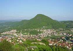
Mrkonjić Grad
Mrkonjić Grad (Serbian Cyrillic: Мркоњић Град; pronounced [mr̩koɲit͡ɕ grad]) is a town and municipality located in western Republika Srpska, an entity of Bosnia and Herzegovina. It is located in the region of Bosanska Krajina, between Banja Luka and Jajce. As of 2013, it has a population of 16,671 inhabitants, while the town of Mrkonjić Grad ha a population of 7,915 inhabitants.
Mrkonjić Grad Мркоњић Град | |
|---|---|
Town and municipality | |
 Mrkonjić Grad | |
.svg.png) Coat of arms | |
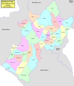
 Location of Mrkonjić Grad within Republika Srpska | |
 | |
| Coordinates: 44°25′N 17°05′E | |
| Country | Bosnia and Herzegovina |
| Entity | Republika Srpska |
| Government | |
| • Mayor | Divna Aničić (SNSD) [1] |
| Area | |
| • Total | 677.43 km2 (261.56 sq mi) |
| Population (2013 census) | |
| • Total | 16,671 |
| • Density | 25/km2 (64/sq mi) |
| Time zone | UTC+1 (CET) |
| • Summer (DST) | UTC+2 (CEST) |
| Area code(s) | 50 |
Name
The town changed its name several times in history: Gornje Kloke, Novo Jajce, Varcarev Vakuf, Varcar Vakuf, and ultimately the present one. The last renaming took place in 1924 after King Peter I of Serbia, who had taken the nom de guerre "Mrkonjić" while fighting in the uprising (1875–78) against the Ottoman Empire.
History
.jpg)
From 1929 to 1941, Mrkonjić Grad was part of the Vrbas Banovina of the Kingdom of Yugoslavia.
In World War II, the town became renowned by the first meeting of ZAVNOBiH on 25 November 1943, when Bosnia and Herzegovina was proclaimed as a common republic of Serbs, Croats and Muslims.
During the Bosnian War from 1992 to 1995, the town was within the territory controlled by Bosnian Serbs. The town is also known for the Mrkonjić Grad incident where the USAF lost one F-16 in June 1995.[2] The pilot of the jet, Scott O'Grady, was stranded in the area for six days before being rescued by US Marines. In 8–12 October 1995, Mrkonjić Grad was in the hands of the Croatian Army (HV) and the Croatian Defence Council (HVO).
After the Dayton peace agreement the town was assigned to the entity of Republika Srpska.[3] In 1996, a mass grave containing the bodies of 181 Serbs—mostly civilians—was uncovered in Mrkonjić Grad. Almost all were killed by Croat forces in late 1995.[4]
Demographics
Population
| Population of settlements – Mrkonjić Grad municipality | |||||||||||
|---|---|---|---|---|---|---|---|---|---|---|---|
| Settlement | 1910. | 1921. | 1931. | 1948. | 1953. | 1961. | 1971.[5] | 1981.[6] | 1991.[7] | 2013.[8] | |
| Total | 20,620 | 27,014 | 29,178 | 31,127 | 30,949 | 30,159 | 29,684 | 26,278 | 16,671 | ||
| 1 | Baljvine | 1,140 | 333 | ||||||||
| 2 | Bjelajce | 980 | 693 | ||||||||
| 3 | Brdo | 587 | 548 | ||||||||
| 4 | Donji Baraći | 524 | 287 | ||||||||
| 5 | Donji Graci | 358 | 206 | ||||||||
| 6 | Gerzovo | 679 | 256 | ||||||||
| 7 | Gornji Graci | 926 | 556 | ||||||||
| 8 | Gustovara | 428 | 208 | ||||||||
| 9 | Kopljevići | 489 | 296 | ||||||||
| 10 | Kotor | 443 | 311 | ||||||||
| 11 | Majdan | 946 | 408 | ||||||||
| 12 | Medna | 791 | 221 | ||||||||
| 13 | Mrkonjić Grad | 2,249 | 2,770 | 4,089 | 6,602 | 8,422 | 7,915 | ||||
| 14 | Oćune | 447 | 215 | ||||||||
| 15 | Orahovljani | 463 | 263 | ||||||||
| 16 | Podbrdo | 991 | 731 | ||||||||
| 17 | Podorugla | 849 | 921 | ||||||||
| 18 | Podrašnica | 1,096 | 733 | ||||||||
| 19 | Šehovci | 642 | 251 | ||||||||
| 20 | Stupari | 435 | 288 | ||||||||
| 21 | Trijebovo | 509 | 211 | ||||||||
Ethnic composition
| Ethnic compsition – Mrkonjić Grad town | |||||||
|---|---|---|---|---|---|---|---|
| 2013.[8] | 1991.[7] | 1981.[6] | 1971.[5] | ||||
| Total | 7,915 (100,0%) | 8,422 (100,0%) | 6,602 (100,0%) | 4,089 (100,0%) | |||
| Serbs | 5,945 (70,59%) | 4,077 (61,75%) | 2,156 (52,73%) | ||||
| Bosniaks | 1,450 (17,22%) | 1,414 (21,42%) | 1,419 (34,70%) | ||||
| Yugoslavs | 470 (5,581%) | 618 (9,361%) | 62 (1,516%) | ||||
| Croats | 454 (5,391%) | 427 (6,468%) | 406 (9,929%) | ||||
| Others | 103 (1,223%) | 19 (0,288%) | 18 (0,440%) | ||||
| Montenegrins | 30 (0,454%) | 21 (0,514%) | |||||
| Albanians | 11 (0,167%) | 6 (0,147%) | |||||
| Macedonians | 6 (0,091%) | 1 (0,024%) | |||||
| Ethnic composition – Mrkonjić Grad municipality | |||||||
|---|---|---|---|---|---|---|---|
| 2013.[8] | 1991.[7] | 1981.[6] | 1971.[5] | ||||
| Total | 16,671 (100,0%) | 27,395 (100,0%) | 29,684 (100,0%) | 30,159 (100,0%) | |||
| Serbs | 16,050 (96,27%) | 21,057 (76,86%) | 23,364 (78,71%) | 24,990 (82,86%) | |||
| Bosniaks | 375 (2,249%) | 3,272 (11,94%) | 3,009 (10,14%) | 2,734 (9,065%) | |||
| Croats | 159 (0,954%) | 2,139 (7,808%) | 2,290 (7,715%) | 2,204 (7,308%) | |||
| Others | 87 (0,522%) | 334 (1,219%) | 67 (0,226%) | 82 (0,272%) | |||
| Yugoslavs | 593 (2,165%) | 883 (2,975%) | 98 (0,325%) | ||||
| Montenegrins | 47 (0,158%) | 38 (0,126%) | |||||
| Albanians | 15 (0,051%) | 11 (0,036%) | |||||
| Macedonians | 8 (0,027%) | 1 (0,003%) | |||||
| Slovenes | 1 (0,003%) | 1 (0,003%) | |||||
Economy
The following table gives a preview of total number of registered employed people per their core activity (as of 2016):[9]
| Activity | Total |
|---|---|
| Agriculture, forestry and fishing | 196 |
| Mining and quarrying | 22 |
| Manufacturing | 814 |
| Distribution of power, gas, steam and air-conditioning | 235 |
| Distribution of water and water waste management | 52 |
| Construction | 499 |
| Wholesale and retail, repair | 490 |
| Transportation and storage | 171 |
| Hotels and restaurants | 145 |
| Information and communication | 25 |
| Finance and insurance | 35 |
| Real estate activities | 1 |
| Professional, scientific and technical activities | 74 |
| Administrative and support services | 3 |
| Public administration and defence | 243 |
| Education | 328 |
| Healthcare and social work | 122 |
| Art, entertainment and recreation | 15 |
| Other service activities | 47 |
| Total | 3,517 |
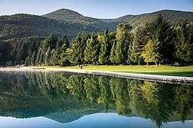
Tourism
The Balkana Lake lies near the town and presents a small, but beautiful tourist resort including the nearby Skakavac Waterfall.
Gallery
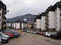 Residential town area
 Hotel Krajina
See also
- Mrkonjić Grad incident
References
- "2004 Nacelnici" (PDF). Archived from the original (PDF) on December 21, 2006. Retrieved February 8, 2016.
- "AFSOUTH Fact sheets". AF South Nato. 2011-03-07. Retrieved 2016-08-06.
- "Dayton Accords - international agreement". Encyclopædia Britannica. Retrieved 2016-08-06.
- "Serbs unearth 181 bodies in mass grave". Independent. 6 April 1996. Retrieved 27 July 2019.
- 1971 Census
- 1981 Census
- 1991 Census
- 2013 Census
- "Cities and Municipalities of Republika Srpska 2017" (PDF). rzs.rs.ba (in Serbian). December 2017. Retrieved 21 October 2018.
External links
| Wikimedia Commons has media related to Mrkonjić Grad. |
- Municipality of Mrkonjić Grad
- Mrkonjić Grad Guide
- Mrkonjić Grad - Internet - Live & Exclusive from MG
- Mrkonjić Grad Portal
- Zelenkovac Art gallery