Khizi District
Khizi (Xızı) is the least-populous district of Azerbaijan. Its capital is the town of Xızı. It is one of the new administrative-territorial units established in 1990 by the decision of the Supreme Soviet of the Republic of Azerbaijan. The district has a remarkable variety of landscapes. On the flat Caspian coast there are irrigated cattle and chicken-breeding[1] lowlands around Shurabad. West of Giläzi, the Xızı road climbs gently through stripily coloured semi-desert landscapes known as the Candy Cane Mountains.[2] Around 10 km west of Xızı town, the green, heavily forested hills around Alti Agach which has been declared an Altyaghach National Park. The national park is home to the rare East Caucasian Tur, a mountain dwelling goat antelope found only in the eastern half of the Caucasus Mountains.[3]
Khizi | |
|---|---|
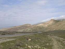 Candy Cane Mountains east of Xızı | |
.svg.png) Map of Azerbaijan showing Khizi District | |
| Country | Azerbaijan |
| Capital | Xızı |
| Area | |
| • Total | 1,850 km2 (710 sq mi) |
| Population (1999) | |
| • Total | 13,080 |
Date of establishment - 24.04.1990, Territory - 1,850 km², Population - 14,300 people (January 1, 2007), Population density - 1 km² 8 people (January 1, 2007)
Khizi District was established in 1990. It is borders with Siyazan and Guba in the north, Shamakhi in the east, Gobustan from the south, and Absheron in the south-east. Basically, the eastern part of the Khizi plateau flows through the Gilazi to the Caspian Sea. Khizi, the center of the district, is 104 km from Baku and is the closest to the capital. The region is surrounded by Varsat, north from Takhtayilak, and from east to Aladdash ridge.
The main mountains are the Dübrar (2205 m), Kemchi (1026), Sharaku (958), Beybayim (935), Shihandag (801) and Great Siyaku (786) mountains. The main rivers are Atacay, Jangichay, Kanda, Tugchay, Dizavarchay, Kerban and Garabulag rivers. There are Altiagac National Park and Wildlife Rehabilitation Center in the area.[4]
Etymology
Azerbaijanis and tats compose the ethnic backghround of Khizi. There are preconceptions about the etymology of the word "xızı" which was previously used to represent a small village. Many experts assume that this name is from the Sassanid Empire. In the early Middle Ages (III-VI centuries), the Iranian tribes were transferred here to spread the Zoroastrianism, the official religion of the Empire, in northern territories of the empire, to combat Christianity and protect the northern borders from Hun, Peach and Khazar tribes. This process further strengthened after the Shirvanshahs were defeated by the Safavids. The tribes who moved here were mainly from Khuzistan. The name was gradually transformed into the form of Khizi in our time.
According to another version, the toponym Khizi is derived from the word "Khazar". From history it is known that for several centuries the Khazars dominated the territories of the Caspian, Black and Baltic seas. As the 8th century Arab historian Ibn Fadlan writes, the Muslim part of the Turkic-speaking Khazar people was headed by one of the representatives of the Khizi tribe. The Khizi tribe lived in the northern part of Azerbaijan in the II century BC. According to another version, the Turkic word "khyz" - quickly, rapidly, hastily gave the name of the area.[5]
Geography
The climate of this place is mild and the air is dry. A large part of the district territory is covered with forests.
One of the most beautiful villages of Azerbaijan – Altiagac is located in Khizi district. The Shirvanshahs and their camel caravans were passing through Altiagac on their way from Shamakhi to Guba. Altiagac was a place where travelers had been camping. Previously, the word "agac" was used as a measure of length. The tree was about 7 kilometers, and the distance from Shamakhi to Altiagac was 42 km.
Landscapes
Khizi District is one of the regions with large forest areas in Azerbaijan (9931 ha, 6%). The area has excessive biodiversity, landscape and ecosystem diversity. There are forest, forest-desert, steppe, desert, gray mountains, subalp and alpine ecosystems. The forest dendroflora consists mainly of iberian oak, eastern oak, eastern peanut, pine tree, juniper, pearl, common. In the sparsely-sparsely wooded forests, trees and shrubs such as spruce pear, hawthorn, blackberries, rabbits, germs, ordinary peas, hips are growing. The riverbeds consist of ordinary pomegranate, pallas nectar and Russian herpes. The fauna of the area is also very rich. Mammals are found in species such as European caterpillars, brown bear boar, rattan rounds, gray rabbits, foxes, hawthorn, wolves, poultry, quail, shepherd, wild aneurysm, gray gooseberry and thrush.
The district is the famous with Beshbarmag mountsain. The rock has been named like this because from a distance it resembles an open palm. Sometimes Khizi is called the country of the red mountains.[6]
Historical monuments
There is a graveyard 300-500 in the former Shikhlar village cemetery located near the village of Tikhti. This tomb is likely to be the Sheikh Heydar's Tomb (X-V century). According to some sources, Sheikh Heydar's tomb is the grave of Sheikh Heydar, the father of Ismayil I, the founder of the Safavid Empire. In 1483 and 1487 he made two campaigns - in Dagestan and Shirvan, which frightened all the rulers of the region, including Sultan Yagub. In order to prevent further strengthening of the positions of Sheikh Heydar, Sultan Yagub helped Shirvanshah Farrukh Yasar to resist him. Sheikh Heydar Shirvanshah died in the Battle of Tabasaran (1488) and was buried in the area opposite the sacred Beshbarmak mountain. Later, Ismayil Safavi, who defeated the Shirvanshahs state, built a tomb on his father's grave, attacked the Shikhlar village and declared the mausoleum a sacred sanctuary. The tower of Beshbarmag, the remains of the lost city of the 5th century, the mausoleum of Sheikh Heydar, the remains of the fallen stone fence of the tower of Khizi relating to Vth century, the 15th century sanctuary in the village of Khialandzh are all examples of historical monuments.[7]
Population
According to the State Statistics Committee, as of 2018, the population of city recorded 16,800 persons, which increased by 3,600 persons (about 27 percent) from 13,200 persons in 2000.[8] 8,300 of total population are men, 8,500 are women.[9] More than 25,5 percent of the population (about 4,300 persons) consists of young people and teenagers aged 14–29.[10]
| Region | 2000 | 2001 | 2002 | 2003 | 2004 | 2005 | 2006 | 2007 | 2008 | 2009 | 2010 | 2011 | 2012 | 2013 | 2014 | 2015 | 2016 | 2017 | 2018 |
|---|---|---|---|---|---|---|---|---|---|---|---|---|---|---|---|---|---|---|---|
| Khizi region | 13,2 | 13,4 | 13,6 | 13,6 | 13,8 | 13,9 | 14,2 | 14,3 | 14,5 | 14,7 | 14,8 | 15,1 | 15,3 | 15,5 | 15,8 | 16,1 | 16,4 | 16,6 | 16,8 |
| urban population | 7,0 | 7,2 | 7,2 | 7,2 | 7,3 | 7,3 | 7,3 | 7,4 | 7,4 | 7,4 | 7,5 | 7,7 | 7,7 | 7,8 | 8,1 | 8,3 | 8,5 | 8,6 | 8,7 |
| rural population | 6,2 | 6,2 | 6,4 | 6,4 | 6,5 | 6,6 | 6,9 | 6,9 | 7,1 | 7,3 | 7,3 | 7,4 | 7,6 | 7,7 | 7,7 | 7,8 | 7,9 | 8,0 | 8,1 |
References
- "Gateway.az". Archived from the original on 2008-11-14. Retrieved 2009-01-16.
- "Xizi (Khizi / Chyzy)".
- Azerb.com
- GoMap. "Хызы, Азербайджан". gomap.az. Retrieved 2018-09-29.
- "Страна агатовых гор: волшебство природы Хызы - ФОТО". Day.Az (in Russian). 2012-12-06. Retrieved 2018-09-29.
- Məmmədov, Q.Ş (2005). Ekologiya və ətraf mühitin mühafizəsi. Bakı: Elm.
- Təhməzov, B (2004). Azərbaycanın bioloji təbiət abidələri. Baku: Adiloğlu.
- "Political division, population size and structure: Population by towns and regions of the Republic of Azerbaijan". The State Statistical Committee of the Republic of Azerbaijan. Retrieved 2018-12-18.
- "Political division, population size and structure: Population by sex, towns and regions, urban settlements of the Republic of Azerbaijan at the beginning of the 2018". The State Statistical Committee of the Republic of Azerbaijan. Retrieved 2018-12-18.
- "Political division, population size and structure: Population at age 14-29 by towns and regions of the Republic of Azerbaijan at the beginning of the 2018". The State Statistical Committee of the Republic of Azerbaijan. Retrieved 2018-12-18.