Qusar District
The District of Qusar (Azerbaijani: Qusar rayonu, Lezgian: КцIар район) is an administrative unit in the northern part of Azerbaijan. Its administrative center is Qusar city.[3][4][5]
Qusar Lezgian: КцIар район | |
|---|---|
| Azerbaijani: Qusar rayonu | |
.svg.png) Map of Azerbaijan showing Qusar Rayon | |
| Coordinates: 41°25′N 48°26′E | |
| Country | |
| Capital | Qusar |
| Villages | 92 |
| Government | |
| • Executive power | Şair Alxasov |
| Area | |
| • Total | 1,542 km2 (595 sq mi) |
| Population (2016) | |
| • Total | 96 199 |
| Time zone | UTC+4 (AZT) |
| • Summer (DST) | UTC+5 (AZT) |
| Postal code | 3800 |
| Telephone code | (+994) 23[2] |
| Website | www |
The district borders upon Quba and Khachmaz rayons of the republic and Dagestan (Russia).
Qusar toponymy
There are several views about the origin of the Qusar toponymy. There is argued that the word "qusar" comes from the Russian language which means "cavalry warrior". "Qusar" regiment was organized in this territory in 1783–1784. The district was named as "Qusar" according to the name of the regiment.
There is another view that the word "qusar" derived from ancient Turkish tribe called "qus/ quz" and "ar" means male.
A. Bakikhanov also used the word "qusar" in his book called Gulistani – Iram. He described the events took place in the village called Qusar.[6]
History
The earliest sediments in the district belong to the Jurassic Period, 135–145 million years old. It is estimated that the life in Qusar district has been existing from the 2nd millennium B.C. Mahmudtapa, the hills of Monsar, the Govdushan hills, the hills of Hafla belonging to the Bronze Age, the hills of Kyzylgul and Agahan, the Halakhur hills belonging to the Middle Ages are ancient dwellings dating back to the 1st millennium B.C.[6]
The district was originated in 1930, and called Gil Rayon with a center in Gil village. In 1934, the center of the rayon was moved to Qusar, and in 1938 it was renamed to Qusar Rayon.
Administrative structure:
- Qullar Village
- Urva Village
Geography
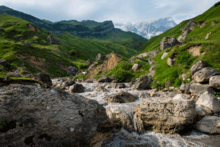
Qusar is located in Eurasian continent, in the north-eastern inclination of the main Caucasus Mountain ridge. It is located between 41°11’ – 41°45’ latitude North and 47°52’ – 48°41’ longitude East. Mountains, among which is also Shahdagh Mount, take the great part of the rayon. Territory of the rayon occupies the northeastern part of Azerbaijan. Qusar is a unique gate of the republic. Even in the ancient times the territory of the rayon took a good position on a junction of the main trade roads. It is 179 kilometres (111 mi) from Qusar to Baku, the capital of Azerbaijan.
The local relief within Qusar district consists of mountains and valleys. Mineral sources such as limestone, chalcopyrite, limonite, and marble are common in the district. Qusar and Samur are main rivers of the Qusar District.[7]
Qusar rayon is located far from sea routes. The most nearest seas to it are the Caspian Sea (15 km, 9.3 mi) and the Black Sea (550 km, 340 mi). Area of the rayon consists of 1,542 km2 (595 sq mi), occupying 1.7% of the area of Azerbaijan. Qusar is the 14th largest rayon in Azerbaijan. The Qusar rayon spans 84 km (52 mi) east-west, by 35 km (22 mi) north-south.
Extreme points of the rayon are:
- In North – Suduroba
- In South – Tufan dagh
- In East – Guzun qishlaq
- In West – Bazarduzu summit
Length of the rayons borders is 225 kilometres (140 mi). Extension of the borders in kilometers:
- Dagestan Republic (with Akhtin, Dokuzpara and Mahammadkend rayons) 95 km (59 mi).
- Qabala Rayon 25 km (16 mi).
- Quba Rayon 70 km (43 mi).
- Khachmaz Rayon 65 km (40 mi).
Flora and Fauna
Oak, peanut and hornbeam are often found in the forest areas.[7] Natural herbs such as cranberry, sumac, hawthorn, wild grapes and blackberries are also grown in the forests.
Wolf, fox, bear, boar, mountain goat and rabbit are particular for forests of the district. There is wild pigeon, quail, green duck and partridge birds in the fields and lakes.[8]
On the territory of the district, Qusar State Nature Sanctuary was established according to the resolution of the Council of Ministers of Azerbaijan SSR dated February 24, 1964 on an area of 15,000 hectares with the purpose of preserving and increasing the number of animals and birds (pheasant, quail, roe, wild boar, rabbit) inhabiting here.[9]
Population
According to data of 2007, population of the rayon consists of 85899 people; 98.67% are Lezgins and 0.86% are the Azerbaijanis.[10] According to the data of 2009, Lezgins are 90.5%, Azerbaijanis are 9.1%, and other nationalities comprise 0.4%. As of 2016, population of rayon grew to 96199 people.[11] Lezgins constituted 2% of the total population of Azerbaijan in 2009 who commonly settled in Qusar district.[12][13] National composition was indicated below in accordance with statistics in 2009.[14]
| Nationalities | Percent |
| lezgins | 90.63 |
| Azerbaijanis | 9.06 |
| Turkish people | 0.12 |
| Russians | 0.10 |
| Khinalug people | 0.02 |
| Qrız | 0.01 |
| Tatars | 0.01 |
| Ukrainians | 0.01 |
| Other nationalities | 0.04 |
The urban population in 2017 accounted for 21% and 79% of the district's population lives in the village.[7]
According to the State Statistics Committee, as of 2018, the population of city recorded 97,200 persons, which increased by 15,400 persons (about 18.8 percent) from 81,800 persons in 2000.[15] 48,600 of total population are men, 48,600 are women.[16] More than 26,9 percent of the population (about 26,200 persons) consists of young people and teenagers aged 14–29.[17]
| Region | 2000 | 2001 | 2002 | 2003 | 2004 | 2005 | 2006 | 2007 | 2008 | 2009 | 2010 | 2011 | 2012 | 2013 | 2014 | 2015 | 2016 | 2017 | 2018 |
|---|---|---|---|---|---|---|---|---|---|---|---|---|---|---|---|---|---|---|---|
| Gusar region | 81,8 | 82,6 | 83,2 | 83,7 | 84,2 | 84,9 | 85,7 | 86,4 | 87,2 | 87,7 | 88,4 | 89,3 | 90,5 | 91,5 | 92,6 | 93,8 | 95,1 | 96,2 | 97,2 |
| urban population | 17,6 | 17,7 | 17,8 | 17,8 | 17,9 | 18,0 | 18,1 | 18,3 | 18,4 | 18,5 | 18,6 | 18,9 | 19,5 | 19,7 | 19,8 | 20,1 | 20,3 | 20,4 | 20,6 |
| rural population | 64,2 | 64,9 | 65,4 | 65,9 | 66,3 | 66,9 | 67,6 | 68,1 | 68,8 | 69,2 | 69,8 | 70,4 | 71,0 | 71,8 | 72,8 | 73,7 | 74,8 | 75,8 | 76,6 |
Religion
- Muslims 98%
Sports and Tourism

Qusar is home of Shahdag Mountain Resort one of the biggest ski resorts in Caucasus and Azerbaijan's first and largest winter resort. Tourist facilities also include such recreational areas as "Alpine Gusar", "Star Gusar", "Gayi Bulak", mountain tourism recreation area "Suvar" and Olympic Sports Complex.
Sightseeing
There are 2 architectural and 46 archaeological monuments in Qusar. The remains of the 13th century fortress in the village of Anigh, the Shaykh Junayd Mausoleum built in 1544 in the village of Hazra (Yargun), are protected by the government as significant architectural monuments of the country.[9] There are also Kohne Khudat and Huray mosques, belonging to the 18th century, Gil, Gyunduzgala and Hasangala mosques, belonging to the 19th century.[18][19] There is a museum named after Russian poet Mikhail Lermontov.[20]
Education
There are 48 secondary schools, 86 general-education schools, 4 non-formal and 13 pre-school education facilities.
In addition, 3 large sports facilities are functioning in Gusar district: Olympic Sports Complex, Central Stadium named after Shovkat Ordukhanov, Children and Youth Sports School.[21]
Economy
Agriculture is a basis of the region's economy. Sown area comprises 34,403 hectares (85,010 acres) (42.2%) of the 81,460 ha (201,300 acres) of land suitable for agriculture. The area of irrigated lands is 29,398 ha (72,640 acres). Agriculture of this region is based on two main fields – crop production and animal husbandry.[22]
Wheat, barley, corn, beans, potatoes, apples, pears, nuts, tomatoes and cabbage are the main crops grown in Qusar. There are more than 5000 hectares of fruit gardens. Nearly 68% of these gardens constitute apple gardens. In order to keep the fruits, cold storage rooms in Chubuglu village (capacity of 4000 tons), Samur settlement (800 tons) and in Yeni hayat village (2000 tons) were built with the governmental support.[22]
Health-care
There are 3 hospital establishments, 19 health posts, 38 medical centers and 61 medical institutions in Qusar district.[23]
Administrative structure
There is 1 city (Qusar), 1 settlement (Samur) and 88 villages in the district which has a territory of 1542 km2.[7] Some of the villages are Anig, Laza, Uzdenoba, Gyunduzkala, Duztahir, Zindanmurug, Suvadzhal, Hiloba, Urva, Chilegir and Yukhary Leger.
Current head of the raion's executive power is Shair Alkhanov since 2007. Under the head of the executive authority, there is acted Council consisted of thirteen members. Villages are controlled by overall 29 municipalities.[24][25][26]
References
- Äliyev, redaksiya heyätinin sädri, Ilham Heydär oğlu (2007). Azärbaycan : Azärbaycan milli ensiklopediyası. Bakı: "Azärbaycan Milli Ensiklopediyası" Elmi märkäzi. ISBN 9789952441017.
- "Şəhərlərarası telefon kodları". Aztelekom MMC. Aztelekom İB. Retrieved 19 August 2015. (in Azerbaijani)
- "Qusar".
- "Кусарский район".
- "Gusar". discoverazerbaijan.az.
- "QUSAR RAYON İCRA HAKİMİYYƏTİ. Tarixi".
- "About - QUSAR RAYON Icra Hakimiyyəti". www.qusar-ih.gov.az. Retrieved 2018-07-05.
- "Qusar rayonunun füsunkar təbiəti turistləri ilin bütün fəsillərində məftun edir" (in Azerbaijani). Retrieved 2018-07-05.
- "Culture". Executive Power of Qusar. Retrieved 2019-06-25.
- "Qusar rayonu". The State Statistical Committee of the Republic of Azerbaijan.
- "QUSAR RAYON İCRA HAKİMİYYƏTİ".
- Verda, Matteo (2014-12-16). Azerbaijan: An introduction to the Country. Edizioni Epoké. ISBN 9788898014361.
- Nuriyev, Elkhan (2007). The South Caucasus at the Crossroads: Conflicts, Caspian Oil and Great Power Politics. Lit. ISBN 9783825862169.
- (www.anarsamadov.net), Anar Samadov. "Qusar rayonu | The State Statistical Committee of the Republic of Azerbaijan". The State Statistical Committee of the Republic of Azerbaijan. Retrieved 2018-07-05.
- "Political division, population size and structure: Population by towns and regions of the Republic of Azerbaijan". The State Statistical Committee of the Republic of Azerbaijan. Retrieved 2018-12-18.
- "Political division, population size and structure: Population by sex, towns and regions, urban settlements of the Republic of Azerbaijan at the beginning of the 2018". The State Statistical Committee of the Republic of Azerbaijan. Retrieved 2018-12-18.
- "Political division, population size and structure: Population at age 14-29 by towns and regions of the Republic of Azerbaijan at the beginning of the 2018". The State Statistical Committee of the Republic of Azerbaijan. Retrieved 2018-12-18.
- "Гусар – край рекордов и рекордсменов".
- "QUSAR RAYON İCRA HAKİMİYYƏTİ. Mədəniyyət".
- "Qusar rayonunun füsunkar təbiəti turistləri ilin bütün fəsillərində məftun edir" (in Azerbaijani). Retrieved 2018-07-07.
- "QUSAR RAYON İCRA HAKİMİYYƏTİ. Tehsil".
- "Economy". Executive Power of Qusar. Archived from the original on 2019-06-25. Retrieved 2019-06-25.
- "QUSAR RAYON İCRA HAKİMİYYƏTİ. Səhiyyə".
- "İcra hakimiyyətinin başçısı - QUSAR RAYON Icra Hakimiyyəti". www.qusar-ih.gov.az. Retrieved 2018-07-07.
- "Şura - QUSAR RAYON Icra Hakimiyyəti". www.qusar-ih.gov.az. Retrieved 2018-07-07.
- "Bələdiyyələr - QUSAR RAYON Icra Hakimiyyəti". www.qusar-ih.gov.az. Retrieved 2018-07-07.
External links
| Authority control |
|
|---|