Ismailli District
Ismailli (Azerbaijani: İsmayıllı rayonu) is a rayon of Azerbaijan.
İsmayıllı | |
|---|---|
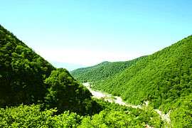 Nature in Ismailli Rayon | |
.svg.png) Map of Azerbaijan showing Ismailli Rayon | |
| Country | |
| Capital | İsmayıllı |
| Area | |
| • Total | 2,074 km2 (801 sq mi) |
| Population (2018) | |
| • Total | 86,100 |
| • Density | 42/km2 (110/sq mi) |
| Postal code | 3100 |
| Telephone code | (+994) 20[1] |
History
Ismailli district was created with the center in the Ismailli village on November 21, 1931. Before the establishment of the district one of its part was in Goychay province, another one in Shamakhy province and the smallest part within Sheki province.
The territory, like all the northern lands of Azerbaijan, was part of the Albanian state in the 4th century B.C. Mehran Gyrdyman from the dynasty of Sasanies even created his own kingdom at the territory. Albanian rulers Varaz Grigor and his son Djavanshir (616-681) were also from the dynasty of mehranids. The Gyrdyman state was ruled by the most prominent ruler of Albania Djavanshir in 638–670. The ruins of the residence built by him on the Aghchay river 4 km from Talystan village is still famous as the Djavanshir tower.
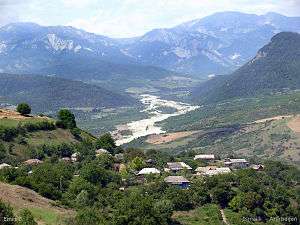
A number of settlements, especially Lahydj and Basgal settlements, Ivanovka, Galadjyg, Talystan and Diyarly villages are notable for their ancient history and special beauty. Lahidj and Basgal were declared the reserves of history and culture.
Ismailli district has a number of ancient historical monuments.
Significant measures are taken for the development of tourism.
The Ismailli city was had been a village until 1959, a settlement until 1967, and after that it was transformed into a city.[2]
Geography
The district covers an area of 2074 km². It borders Guba in the north, Shamakhy in the east, Aghsu in the southeast, Kurdemir in the south, Goychay in the southwest and Gabala in the west.
Ismailli district includes one city, two settlements and 106 villages. These settlements are controlled by 34 territorial representations and 67 municipalities.
The landscape is mainly composed of mountains. Altitudes hesitate between 200 meters up to 3629 meters (Babadagh) above sea level. The area is passed by the Goychay, Gyrdyman, Akhokh, Ayrichay, Sulut and other rivers, Yekekhana and Ashygbayram artificial ponds.
The district covers 2,158.75 km² with 220.58 km² of winter and 135.55 km² of summer pastures. The lands used in agriculture account for 966.3 km² including 36.263 km² of fertile lands.
Woodlands account for 667.99 km². The district accounts for the State Reserve of Ismayilli. The part of the district was included into the Shahdagh National Park.
.jpg)
Ismailly district has a rich nature. The forests are composed of oak, hornbeam, beech-tree, alder-tree, birch-tree, poplar, pear, spoke and other trees. Such fauna as elk, mountain goat, chamois, deer, roe deer, bear, boar, lynx, fox, wolf, squirrel, coon, pheasant, partridge, eagle, falcon, tetra and others are found in the forests.
Demographics
Its population was 86,100 persons on January 1, 2018. Azerbaijanis are majority. Tats, Armenians, Russians and Lezgians are other ethnic groups of Ismailli District.
| Ethnic group | 1939 Census[3][4] | 1959 Census[5] | 1970 Census[6] | 1979 Census[7] | 1999 Census[8] | 2009 Census[9] | ||||||
|---|---|---|---|---|---|---|---|---|---|---|---|---|
| Population | % | Population | % | Population | % | Population | % | Population | Population | % | ||
| Azerbaijanis | 30 234 | 57.65% | 28 889 | 71.02% | 39 171 | 75.92% | 43 627 | 78.96% | 61 190 | 84.82% | 68 448 | 86.28% |
| Lezgins | 3 149 | 6.00% | 3 255 | 8.00% | 4 883 | 9.46% | 5 788 | 10.48% | 7 722 | 10.70% | 8 076 | 10.18% |
| Russians | 4 460 | 8.50% | 4 017 | 9.88% | 3 768 | 7.30% | 3 213 | 5.82% | 2 514 | 3.49% | 2 024 | 2.55% |
| Kurds | 4 | 0.01% | ... | ... | 1 | 0.01% | ... | ... | 382 | 0.53% | 498 | 0.63% |
| Meskhetian Turks | 1 | 0.01% | ... | ... | ... | ... | ... | ... | 244 | 0.34% | 194 | 0.25% |
| Ukrainians | 157 | 0.30% | ... | ... | 58 | 0.11% | ... | ... | 25 | 0.03% | 9 | 0.01% |
| Tatars | 21 | 0.04% | ... | ... | 25 | 0.05% | 8 | 0.01% | 22 | 0.03% | 7 | 0.01% |
| Jews | 300 | 0.57% | 46 | 0.11% | 15 | 0.03% | 155 | 0.28% | 15 | 0.02% | 7 | 0.01% |
| Mountain Jews | 217 | 0.42% | ||||||||||
| Armenians | 6 683 | 12.74% | 4 038 | 9.93% | 3 308 | 6.41% | 2 377 | 4.30% | 5 | 0.01% | ... | ... |
| Avars | 4 | 0.01% | ... | ... | 4 | 0.01% | 8 | 0.01% | ... | ... | ... | ... |
| Georgians | 9 | 0.02% | 6 | 0.01% | 13 | 0.02% | 7 | 0.01% | ... | ... | ... | ... |
| Udi people | 7 250 | 13.82% | ... | ... | ... | ... | 2 | 0.01% | ... | ... | ... | ... |
| Tat people | ... | ... | 40 | 0.08% | ... | ... | ... | ... | ... | ... | ||
| Germans | 46 | 0.09% | ... | ... | ... | ... | ... | ... | ... | ... | ... | ... |
| Talysh people | 37 | 0.07% | ... | ... | ... | ... | ... | ... | ... | ... | ... | ... |
| Others | 90 | 0.17% | 428 | 1.05% | 93 | 0.18% | 64 | 0.12% | 25 | 0.03% | 67 | 0.08% |
| Total | 52 445 | 100% | 40 679 | 100% | 51 596 | 100% | 55 249 | 100% | 72 144 | 100% | 79 330 | 100% |
Population
According to the Annual report of the State Statistics Committee, the total number of population in 2000 was 73,000. In 2018, this indicator increased by 13,100 people.[10]
| 2000 | 2001 | 2002 | 2003 | 2004 | 2005 | 2006 | 2007 | 2008 | 2009 | 2010 | 2011 | 2012 | 2013 | 2014 | 2015 | 2016 | 2017 | 2018 | |
|---|---|---|---|---|---|---|---|---|---|---|---|---|---|---|---|---|---|---|---|
| Ismayilly region | 73,0 | 73,6 | 74,2 | 74,9 | 75,6 | 76,4 | 77,1 | 77,8 | 78,6 | 79,2 | 80,0 | 80,9 | 81,7 | 82,4 | 83,1 | 84,0 | 84,9 | 85,5 | 86,1 |
| urban population | 15,4 | 15,6 | 15,8 | 16,0 | 16,3 | 16,5 | 16,7 | 16,9 | 17,1 | 17,3 | 17,4 | 17,6 | 17,7 | 26,7 | 26,9 | 27,2 | 27,6 | 27,8 | 27,9 |
| rural population | 57,6 | 58,0 | 58,4 | 58,9 | 59,3 | 59,9 | 60,4 | 60,9 | 61,5 | 61,9 | 62,6 | 63,3 | 64,0 | 55,7 | 56,2 | 56,8 | 57,3 | 57,7 | 58,2 |
Language
Media
Sociopolitical newspaper Girdyman was established in 2002 and is issued twice or thrice a month in 500 editions. It was founded by the executive body of the district and the creative collective of the publishing house. It was registered by the Ministry of Justice of the Republic of Azerbaijan with registration number 120.
The publication of a local newspaper commenced in 1934. It was called Yeni Ismayilly from 1934 to 1966, Zehmetkesh from 1966 to 1991 and Djavanshir yurdu from 1991.
The radio station of the district was registered in the head department for mass media under the State Press Committee and started operating on February 10, 1993. It aims to provide the residents of Ismayilly with daily sociopolitical news, entertaining programs and programs for children, ads, announcements and other programs. It transmits its programs thirty minutes a day except for Saturday and Sunday.
It is the executive body of the district. It has previously operated as a ten-minute news bulletin in a local newspaper.
Agriculture
In comparison with 1995 in 2001, potato production expanded by 41 times (3497 tons), vegetables by 12.4 times (4973 tons), grain 2.2 times (65683 tons), fruit and berry products 49 times (7151 tons), wheat 2, 3 times (46,194 tons). Along with this, within the period under survey the vineyards within the locale decreased by 2711 hectares and production decreased by 5931 tons. The production of the most crops within the agricultural segment expanded by 38.6 per cent, vegetables by 55.7, grain by 7.9 per cent, fruit and berry products by 113.6 per cent, wheat by 11.3 quintals per hectare in agriculture. The production of animals products within the region a few changes have been watched. Therefore, the number of livestock within the locale was 10,104 heads in 2001 compared to 1995, the number of cows and buffalo was 6474, sheep and goats was 50447 heads.
Major agricultural plants
- Wheat
- Corn
- Peas
- Sunflower
- Beans
- Potato
- Tomato
- Cucumber
- Cabbage
- Onion
- Garlic
Fruits
- Grapes
- Apple
- Pear
- Walnut
- Hazelnut
Prominent people
Hajji Agadadash Hagverdiyev
Notes
- "Şəhərlərarası telefon kodları". Aztelekom MMC. Aztelekom İB. Retrieved 19 August 2015. (in Azerbaijani)
- "TERRITORIAL AND ADMINISTRATIVE UNITS: District of Ismayilli" (PDF). Administrative Department of the President of the Republic of Azerbaijan.
- "Исмаиллинский район 1939". www.ethno-kavkaz.narod.ru. Retrieved 2018-10-16.
- "Всесоюзная перепись населения 1939 года. Национальный состав населения районов, городов и крупных сел союзных республик СССР. Азербайджанский ССР >> Исмаиллинский // Источник: РГАЭ РФ (быв. ЦГАНХ СССР), фонд 1562, опись 336, Д.Д. 966-1001 ("Национальный состав населения по СССР, республикам, областям, районам"), Д.Д. 256-427 (табл. 26 "Национальный состав населения районов, районных центров, городов и крупных сельских населенных пунктов") — yoxlanılıb: 21.04.2018". www.demoscope.ru. Retrieved 2018-10-16.
- "Исмаиллинский район 1959". www.ethno-kavkaz.narod.ru. Retrieved 2018-10-16.
- "Исмаиллинский район 1970". www.ethno-kavkaz.narod.ru. Retrieved 2018-10-16.
- "Исмаиллинский район 1979". www.ethno-kavkaz.narod.ru. Retrieved 2018-10-16.
- "Ethnic composition of Azerbaijan 1999". pop-stat.mashke.org. Retrieved 2018-10-16.
- "Ethnic composition of Azerbaijan 2009". pop-stat.mashke.org. Retrieved 2018-10-16.
- "Political division, population size and structure: Population by towns and regions of the Republic of Azerbaijan".
Ne`mat... The village consists of approximately 15 house with 45 dwellers in it. There is no school or other state offices. There are a historical graves from older alban troops. Main people is Lezgi minorities.