Agsu District
Ağsu | |
|---|---|
.svg.png) Map of Azerbaijan showing Agsu Rayon | |
| Country | Azerbaijan |
| Capital | Ağsu |
| Area | |
| • Total | 1,020 km2 (390 sq mi) |
| Population (2007) | |
| • Total | 65,900 |
| • Density | 65/km2 (170/sq mi) |
| Website | agsu-ih.gov.az |
Agsu (Ağsu) is a raion in central Azerbaijan.
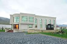
General information
According to some sources that Agsu city was founded by Nadir Shah, in 1735. The remainders of that city (“Ruined city”) is situated in the south of Agsu city. The name of the city is derived from “Agsuchay” which flow through the city. City status was given to Agsu, in 1967. Agsu district was arranged, in 1943. it is bounded by Ismayilli from the north and north-west, Shamakhi from the north-west and east, Kurdamir and Hadzhigabul from the south.
Its territory is 1020 km2, population in 69.4 persons. There are a city (Agsu city), 78 villages. These dwelling areas are embraced by 24 territorial representations and 60 municipalities. Gagali, Kendoba, Bijo, Calva, Pirhassanli, Dzhalayir, Padar, Arabushagi and Garagoyunlu are the greatest villages of the district.
49.1% of the population is male, 50.9% is female. 98,92% of the population is Azerbaijani, 1,08% is Lezghin, Turkish and other. 25.7% of the population lives in the city, 74.3% lives in villages. 2068 refugees and forced immigrants were settled down in the district. They are moved here from Armenia, Uzbekistan and our occupied regions.
69 schools providing general education, 5 out-of-school and pre-school institutes, 6 hospitals, 18 ambulatory-polyclinics, 22 doctor's assistant-mama dispensaries, a cultural palace, 10 cultural houses, 47 libraries, a musical school for children and history-ethnographical museum operate in the district.
In 1954, the first newspaper “Yeni Heyat” (“New Life”) was published in the district. Then, inter-regional newspaper “Irali” (“Forward”) was published in 1961 and newspaper “Birlik” (“Unity”) was published in 1966. Nowadays, newspaper “Agsu” which is agency of Executive Government of Agsu district is published in the district. The newspaper was registered in the Ministry of Justice of Azerbaijan Republic, on January 13, 2003.
There are 55 km road of republican importance through the district. 37 km the road Baku-Shamakhi Yevlakh is second categorical road, 18 km road Agsu-Kurdamir-Behramtapa is third categorical road.
Regional organization of 16 political parties and regional department of 16 social-political organizations (including, 3 non-governmental organizations) operate in the district. Regional organization of Yeni Azerbaijan Party in Agsu district takes an important role in social-political, cultural life of the district. The main organizations of YAP were founded in the district, in the beginning of 1993. Constituent Assembly was held in November, 1993.[1]
Geographical location
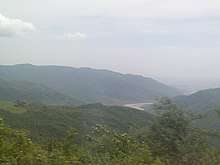
According to the geographical location, Agsu district is located at the bottoms of the Great Caucasian Mountains and on the plain of Shirvan. 6 villages, 3 territory units are mountainous zone. Relief of the district consists of mountainous, foothills and slanting flats. Mountainous zone is located in 700–1000 m height above sea level. Relief of the mountainous zones is compound with rivers, valleys, ravines. Langabiz mountain chain is formed by small grey mountains from the banks of Goycay River to Pirsaatchay River. Its highest peak Sendelen (it is also known as "Sangalan" and "Bijo mountain") situated in the territory of Bijo village has the 929 m height above sea level.
The Girdiman and the Agsuchay and their branches flow through the district. Kukash gorge and Djavanshir Lake (in the west), Yukhari Shirvan canal and its branch Agsu (in the south) as well as little Bijoderesi river are located in the district.
Climate of the district is, semi desert, dry gray, winter months are usually mild, warm and dry (the south) and summer months are usually mild, warm and dry. Winter is dry, sunny and less snowy. Average annual temperature is 13-14 C. average monthly relative humidity is 50-81% during year. Annual quantity of rain is 400–600 mm.[2]
Agsuchay begins to flow from Lahij Mountains. Middle flow of the rain is too deep, but it flows through wide valley. The valley of the river loses its form beginning from Agsu city to the south. Here the river is used for irrigation of farming lands.[2]
Population
According to the State Statistics Committee, as of 2018, the population of city recorded 79,200 persons, which increased by 16,100 persons (about 25.5 percent) from 63,100 persons in 2000.[3] 39,800 of total population are men, 39,400 are women.[4] More than 27,3 percent of the population (about 21,700 persons) consists of young people and teenagers aged 14–29.[5]
| Territory | 2000 | 2001 | 2002 | 2003 | 2004 | 2005 | 2006 | 2007 | 2008 | 2009 | 2010 | 2011 | 2012 | 2013 | 2014 | 2015 | 2016 | 2017 | 2018 |
|---|---|---|---|---|---|---|---|---|---|---|---|---|---|---|---|---|---|---|---|
| Aghsu region | 63,1 | 63,9 | 64,6 | 65,4 | 66,1 | 67,0 | 67,9 | 68,5 | 69,4 | 70,3 | 71,0 | 72,1 | 73,2 | 74,1 | 75,1 | 76,3 | 77,3 | 78,3 | 79,2 |
| urban population | 16,6 | 16,9 | 17,2 | 17,6 | 17,8 | 18,3 | 18,7 | 18,9 | 19,3 | 19,7 | 19,8 | 20,1 | 20,2 | 20,4 | 20,7 | 21,0 | 21,3 | 21,5 | 21,8 |
| rural population | 46,5 | 47,0 | 47,4 | 47,8 | 48,3 | 48,7 | 49,2 | 49,6 | 50,1 | 50,6 | 51,2 | 52,0 | 53,0 | 53,7 | 54,4 | 55,3 | 56,0 | 56,8 | 57,4 |
Historical monuments of Agsu
The statues of ram built in the Middle Ages bring the great interest to Agsu region. Even the figures of ram on the graves are observed in Padar village, Mustafa village. In Azerbaijan these kinds of statues can be seen frequently. These types of the grave monuments are widely used in the South Caucasus, East Anadolu, Middle Asia, Sibir, and Altay.
In ancient times, ram was the symbol of abundance, victory and strength. It should be mentioned that the early information about stone ram figures comes from the foreign travellers who visited Azerbaijan in the XIII-XIX centuries. These ram statues are related to the Middle Ages historical Azerbaijani governments Aghoyunlu and Garagoyunlu.[6]
Sheikh Dursun Mausoleum (XV century), “Xəzinə dağı” (Treasure Hill) tower, Sheikh Amir Ahmed Mausoleum (1722), Pir Bakhtiyar Mausoleum (XVIII century) are among the historical monuments of Agsu district. Red dome and white dome are located in Garagoyunlu village. The walls of Red dome constructed in 1869-1870 in an octahedral prism shape were built of red-baked bricks. The white dome was built of white limestones in 1909.[7]
Culture and tourism
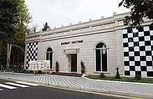
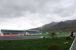
Agsu region has a number of amenities offering a wide range of services, such as Agsu region History and Ethnography Museum displaying archaeological artifacts date back to the III-I centuries BC and other historical exhibits,[8] Agsu region Cultural Center featuring “Goncha” folk instrumental ensemble, "New Aghsu" vocal instrumental ensemble. "Ashugs" ensemble,[9] Ethnography Houses in Garagoyunlu, Padar and Bozavand villages, Craftsmanship centers in Bijo and Yenilik villages, Culture houses in Jalayir and Kalva villages, Agsu region Children’s Music School, Agsu Chess School, Agsu Children and Youth Art Center, Agsu region Heydar Aliyev Center. There is also a stadium with a capacity of 3000 and a sports complex.[10] “Agsu” newspaper is published in the region.[11]
Agriculture
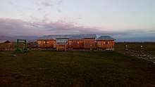
Agsu district is agricultural district. Cattle-breeding, grain-growing, cotton-growing, fruit-growing and vegetable-growing are the most important fields of the district's economy. 75.2% or 76742 hectare of its territory is useful for agriculture, 46.3% or 35550 hectare of it consists of arable land.
Economy of the district is arranged by the agricultural activity. In 2007, total output of the district was 55879.9 thousand manats, and 36685.8 thousand manats or 66 per cent falls to agriculture's share. Vegetable products of 21644 thousand manats, cattle-breeding products of 15042 thousands manats were produced in the district.
36184 hectare arable lands were freely given to long-term 43892 proprietors as a result of carried out agrarian reforms in National Leader Heydar Aliyev's initiative and under his leadership. Property of sovkhozes and kolkhozes in the sum of AZM 17.8 billion (AZN 3.6mln.) was privatized and share permission was given to the proprietors. 98-100% of production of the district, retail commodity circulation, paying services falls to non-governmental sector's share.
Poultry
Development of poultry in the district was considered in the State Program “Social-economic development of the regions of Azerbaijan Republic” (2004–2008 years). Inhabitants are busy with poultry in all zones. Three private incubation workshops seasonally operate in the district. Industrial method of poultry is under control. “Shaban-Poultry” LLC has operated in Musabeyli village since 2005. Birds for slaughter are breed in the establishment. Ten thousand birds were breed in the first quarter of current year and seven thousand of them were sold.
Cattle-breeding
Cattle-breeding dynamically develops in the district. Cattle is breed for dairy and slaughter. Two physical persons are busy cattle-breeding (including, one is busy with buffalo-breeding), one juridical person and three physical persons are busy with sheep-breeding. Domestic agriculture form and other forms of cattle-breeding rapidly develop in the district. There were 39235 cattle, 149679 sheep and goats in the district, on July 1, 2008. Cattle production also increased. 3939 ton (live) meat, 23302 ton milk and 274 ton wool were produced.
Plant-growing
Wheat, barley, alfalfa, maize, sunflower, water-melon and vegetable, sugar-beet, potato, cotton, grape, pomegranate and other plants are cultivated in the district. In 2007, 80018 ton grain (in 27520 hectare area), 1032.1 ton cotton, 311.4 ton potato, 1818.6 ton vegetable, 3932.2 ton water-melon, 5053 ton fruit were cultivated in the district by private farmers and proprietors of individual plots. 81.6 thousand ton grain was produced in the district till July 15, 2008. It's 1600 ton more than last year. Productivity indicator reached to 29.3 quintal.
See also
References
- "TERRITORIAL AND ADMINISTRATIVE UNITS: District of Agsu" (PDF). Administrative Department of the President of the Republic of Azerbaijan.
- "Geographical location of Agsu". Executive Power of Agsu District. Retrieved 2019-04-09.
- "Political division, population size and structure: Population by towns and regions of the Republic of Azerbaijan". The State Statistical Committee of the Republic of Azerbaijan. Retrieved 2018-12-18.
- "Political division, population size and structure: Population by sex, towns and regions, urban settlements of the Republic of Azerbaijan at the beginning of the 2018". The State Statistical Committee of the Republic of Azerbaijan. Retrieved 2018-12-18.
- "Political division, population size and structure: Population at age 14-29 by towns and regions of the Republic of Azerbaijan at the beginning of the 2018". The State Statistical Committee of the Republic of Azerbaijan. Retrieved 2018-12-18.
- "History of Agsu".
- "Culture". Executive Power of Agsu district. Retrieved 2019-04-09.
- "Agsu region History and Ethnography Museum". Ministry of Culture of Azerbaijan - Ismayilli Regional Office. Retrieved 2019-04-09.
- "Agsu region Cultural Center". Ministry of Culture of Azerbaijan - Ismayilli Regional Office. Retrieved 2019-04-09.
- "Ilham Aliyev attended a ceremony to start water supply to Aghsu". en.president.az. Retrieved 2019-04-09.
- "About Agsu district". Executive Power of Agsu District. Retrieved 2019-04-09.