Idaho statistical areas
The statistical areas of the United States of America comprise the metropolitan statistical areas (MSAs),[1] the micropolitan statistical areas (μSAs),[2] and the combined statistical areas (CSAs)[3] currently defined by the United States Office of Management and Budget (OMB).
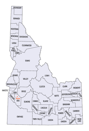
Most recently on March 6, 2020, the Office of Management and Budget defined 1114 statistical areas for the United States,[4] including four combined statistical areas, eight metropolitan statistical areas, and 10 micropolitan statistical areas in the State of Idaho. The table below shows the recent population of these statistical areas and the 44 counties of Idaho.
Table
The table below describes the 22 United States statistical areas and 44 counties of the State of Idaho with the following information:[5]
- The combined statistical area (CSA) as designated by the OMB.[4]
- The CSA population according to 2019 US Census Bureau population estimates.[6]
- The core based statistical area (CBSA)[7] as designated by the OMB.[4]
- The CBSA population according to 2019 US Census Bureau population estimates [6]
- The county name
- The county population according to 2019 US Census Bureau population estimates [6]
| Combined Statistical Area | 2019 Population | Core Based Statistical Area | 2019 Population | County | 2019 Population |
|---|---|---|---|---|---|
| Boise City-Mountain Home-Ontario, ID-OR CSA | 831,235 800,664 |
Boise City, ID MSA | 749,202 | Ada County, Idaho | 481,587 |
| Canyon County, Idaho | 229,849 | ||||
| Gem County, Idaho | 18,112 | ||||
| Owyhee County, Idaho | 11,823 | ||||
| Boise County, Idaho | 7,831 | ||||
| Ontario, OR-ID μSA | 54,522 23,951 |
Malheur County, Oregon | 30,571 | ||
| Payette County, Idaho | 23,951 | ||||
| Mountain Home, ID μSA | 27,511 | Elmore County, Idaho | 27,511 | ||
| Idaho Falls-Rexburg-Blackfoot, ID CSA | 251,347 | Idaho Falls, ID MSA | 151,530 | Bonneville County, Idaho | 119,062 |
| Jefferson County, Idaho | 29,871 | ||||
| Butte County, Idaho | 2,597 | ||||
| Rexburg, ID μSA | 53,006 | Madison County, Idaho | 39,907 | ||
| Fremont County, Idaho | 13,099 | ||||
| Blackfoot, ID μSA | 46,811 | Bingham County, Idaho | 46,811 | ||
| Spokane-Spokane Valley-Coeur d'Alene, WA-ID CSA | 734,218 165,697 |
Spokane-Spokane Valley, WA MSA | 568,521 | Spokane County, Washington | 522,798 |
| Stevens County, Washington | 45,723 | ||||
| Coeur d'Alene, ID MSA | 165,697 | Kootenai County, Idaho | 165,697 | ||
| none | Twin Falls, ID MSA | 111,290 | Twin Falls County, Idaho | 86,878 | |
| Jerome County, Idaho | 24,412 | ||||
| Pocatello, ID MSA | 95,489 | Bannock County, Idaho | 87,808 | ||
| Power County, Idaho | 7,681 | ||||
| Sandpoint, ID μSA | 45,739 | Bonner County, Idaho | 45,739 | ||
| Burley, ID μSA | 45,069 | Cassia County, Idaho | 24,030 | ||
| Minidoka County, Idaho | 21,039 | ||||
| Lewiston, ID-WA MSA | 62,990 40,408 |
Nez Perce County, Idaho | 40,408 | ||
| Asotin County, Washington | 22,582 | ||||
| Pullman-Moscow, WA-ID CSA | 90,212 40,108 |
Pullman, WA μSA | 50,104 | Whitman County, Washington | 50,104 |
| Moscow, ID μSA | 40,108 | Latah County, Idaho | 40,108 | ||
| none | Hailey, ID μSA | 24,127 | Blaine County, Idaho | 23,021 | |
| Camas County, Idaho | 1,106 | ||||
| Logan, UT-ID MSA | 142,165 13,876 |
Cache County, Utah | 128,289 | ||
| Franklin County, Idaho | 13,876 | ||||
| Jackson, WY-ID μSA | 35,588 12,124 |
Teton County, Wyoming | 23,464 | ||
| Teton County, Idaho | 12,124 | ||||
| none | Idaho County, Idaho | 16,667 | |||
| Gooding County, Idaho | 15,179 | ||||
| Shoshone County, Idaho | 12,882 | ||||
| Boundary County, Idaho | 12,245 | ||||
| Valley County, Idaho | 11,392 | ||||
| Washington County, Idaho | 10,194 | ||||
| Benewah County, Idaho | 9,298 | ||||
| Clearwater County, Idaho | 8,756 | ||||
| Lemhi County, Idaho | 8,027 | ||||
| Caribou County, Idaho | 7,155 | ||||
| Bear Lake County, Idaho | 6,125 | ||||
| Lincoln County, Idaho | 5,366 | ||||
| Oneida County, Idaho | 4,531 | ||||
| Custer County, Idaho | 4,315 | ||||
| Adams County, Idaho | 4,294 | ||||
| Lewis County, Idaho | 3,838 | ||||
| Clark County, Idaho | 845 | ||||
| State of Idaho | 1,787,047 | ||||
See also
- State of Idaho
- Outline of Idaho
- Index of Idaho-related articles
- Geography of Idaho
- Demographics of Idaho
- Idaho counties
- Idaho statistical areas
- Geography of Idaho
- Demographics of the United States
- United States Census Bureau
- List of US states and territories by population
- List of US cities by population
- Cities and metropolitan areas of the US
- United States Office of Management and Budget
- Statistical Area
- Primary Statistical Area
- List of the 725 PSAs
- Combined Statistical Area
- List of the 128 CSAs
- Core Based Statistical Area
- List of the 955 CBSAs
- Metropolitan Statistical Area
- List of the 374 MSAs
- List of US MSAs by GDP
- Micropolitan Statistical Area
- List of the 581 μSAs
- Primary Statistical Area
- Statistical Area
- United States Census Bureau
References
- The United States Office of Management and Budget (OMB) defines a metropolitan statistical area (MSA) as a core based statistical area having at least one urbanized area of 50,000 or more population, plus adjacent territory that has a high degree of social and economic integration with the core as measured by commuting ties.
- The United States Office of Management and Budget (OMB) defines a micropolitan statistical area (μSA) as a core based statistical area having at least one urban cluster of at least 10,000 but less than 50,000 population, plus adjacent territory that has a high degree of social and economic integration with the core as measured by commuting ties.
- The United States Office of Management and Budget (OMB) defines a combined statistical area (CSA) as an aggregate of adjacent core based statistical areas that are linked by commuting ties.
- OMB BULLETIN NO. 20-01: Revised Delineations of Metropolitan Statistical Areas, Micropolitan Statistical Areas, and Combined Statistical Areas, and Guidance on Uses of the Delineations of These Areas Archived 2020-04-20 at the Wayback Machine. Office of Management and Budget. March 6, 2020.
- An out-of-state area and its population are displayed in green. An area that extends into more than one state is displayed in teal. A teal population number over a black population number show the total population versus the in-state population.
- "Annual Estimates of the Resident Population for Counties in the United States: April 1, 2010 to July 1, 2019". United States Census Bureau, Population Division. April 2020. Retrieved April 9, 2020.
- The United States Office of Management and Budget (OMB) defines a core based statistical area as one or more adjacent counties or county-equivalents having at least one urban cluster of at least 10,000 population, plus adjacent territory that has a high degree of social and economic integration with the core as measured by commuting ties. The core based statistical areas comprise the metropolitan statistical areas and the micropolitan statistical areas.
External links
Boise (capital) | ||
| Topics |
|  Seal of Idaho |
| Society | ||
| Regions | ||
| Larger cities | ||
| Smaller cities | ||
| Counties |
| |