Girnar
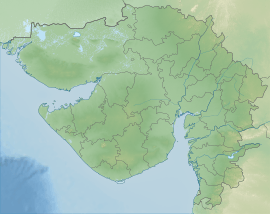
Girnar, also known as Girinagar ('city-on-the-hill') or Revatak Parvata, is a group of mountains in the Junagadh District of Gujarat, India.
| Mount Girnar | |
|---|---|
| ગિરનાર પર્વત Girinagar Revatak Parvata | |
 Girnar Hill from Bhavnath | |
| Highest point | |
| Elevation | 1,069 m (3,507 ft) |
| Listing | List of Indian states and territories by highest point |
| Coordinates | 21°29′41″N 70°30′20″E |
| Geography | |
| Geology | |
| Mountain type | Igneous |

Geology
Mount Girnar is a major igneous plutonic complex which intruded into the basalts towards the close of the Deccan Trap period. The rock types identified in this complex are gabbros (tholeiitic and alkalic), diorites, lamprophyres, alkali-syenites and rhyolites. The parent gabbroic magma is shown to have given rise in sequence to diorites, lamprophyres and alkali-syenites. The rhyolite, though earlier considered a product of differentiation, is now believed to be an independent magma without any genetic link with the gabbro and its variants.[1][2]
History
Mount. Girnar is older than the Himalayas and the Jain temples upon it are amongst the most ancient in the country; it is the Nirvan bhumi of 22nd Tirthankara Lord Neminatha. It is 3666 feet high, and is one of the most remarkable mountains in India. From the city of Junagadh, which is at an altitude of barely 351 feet only the top of Mount Girnar can be seen, as it has in front of it lower hills, of which Jogniya, or Laso Pawadi, 2527 feet; Lakhshman Tekri, Bensla, 2290 feet high; and Datar, 2779 feet high, are the principals.[3]
Ashoka's edicts at Mount Girnar, Junagadh
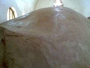
Fourteen of Ashoka's Major Rock Edicts, dating to circa 250 BCE, are inscribed on a large boulder that is housed in a small building located outside the town of Junagadh on Saurashtra peninsula in the state of Gujarat, India. It is located on Girnar Taleti road, at about 2 km (1.2 mi) far from Uperkot Fort easterly, some 2 km before Girnar Taleti. An uneven rock, with a circumference of seven meters and a height of ten meters, bears inscriptions etched with an iron pen in Brahmi script in a language similar to Pali and date back to 250 BCE, thus marking the beginning of written history of Junagadh.[4]
On the same rock there are inscriptions in Sanskrit added around 150 CE by Mahakshatrap Rudradaman I, the Saka (Scythian) ruler of Malwa, a member of the Western Satraps dynasty (see Junagadh rock inscription of Rudradaman).[4] The edict also narrates the story of Sudarshan Lake which was built or renovated by Rudradaman I, and the heavy rain and storm due to which it had broken.
Another inscription dates from about 450 CE and refers to Skandagupta, the last Gupta Empire.
The protective building around the edicts was built in 1900 by Nawab Rasool Khan of Junagadh State at a cost of Rs 8,662. It was repaired and restored in 1939 and 1941 by the rulers of Junagadh. The wall of the structure had collapsed in 2014.[5]
A much smaller replica of these Girnar edicts has been positioned outside the entrance of the National Museum in Delhi.
 Housing for Ashoka's edicts.
 The rock with inscriptions.
 Rubbing of part of the inscriptions.
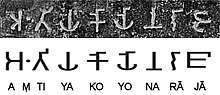
Girnar's Initial trek

The base of the mountain, known as Girnar Taleti, is about 4 km east of the center of Junagadh. There are temples and other sacred places all along this stretch.
The traveller, in order to reach Girnar Taleti from Junagadh city, will pass through the Wagheshwari or Vagheshwari Gate [Girnar Darwaza], which is close to the Uparkot fort area, Easterly.
At about 200 metres from the gate, to the right of the road, is the Temple of Wagheshwari (Upale Vagheshwari maa), which is joined to the road by a causeway about 150 yards long. An ancient Verai Mata mandir and a modern Gayatri Shakti Peeth mandir are nearby.
About a furlong beyond this is a stone bridge, and just beyond it on the right are the Ashoka's Major Rock Edicts.[3] The edicts are inscribed high up on a large, domed mass of black granite measuring roughly 20 feet x 30 feet. The inscription is in Brahmi script.[4] On the same rock can be found an inscription of the Western Satrap ruler Rudradaman, the Junagadh rock inscription of Rudradaman.
On leaving Ashoka's edicts, the route crosses the handsome bridge over the Sona-rekha, which here forms a fine sheet of water over golden sand, then passes a number of temples, at first on the left bank of the river and then on the right, to the largest of the temples. This is dedicated to Damodar, a name of Krishna, from Dam, a rope, because by tradition his mother in vain attempted to confine him with a rope when a child. The reservoir, Damodar Kund, at this place is accounted very sacred.[3]
Next is an old shrine of Bhavnath, a form of Shiva, close to Girnar Taleti; Mrigi kund and Sudharshan lake are nearby.
Most persons who are not active climbers will probably proceed up the mountain in a swing doli from Taleti. A long ridge runs up from the west, and culminates in a rugged scarped rock, on the top of which are the temples. Close to the old shrine is a well called the Chadani vav.[3]
The paved way begins just beyond this and continues for two-thirds of the ascent. The first resthouse, Chadia Parab, is reached, 480 feet, above the plain; and the second halting-place at Dholi-deri, 1000 feet above the plain. From here the ascent becomes more difficult, winding under the face of the precipice to the third resthouse, 1400 feet up. The path turns to the right along the edge of a precipice, which is very narrow, so that the doli almost grazes the scarp, which rises perpendicularly 200 feet above the traveller. On the right is seen the lofty mountain of Datar, covered with low jungle. At about 1500 feet there is a stone dharmsala, and from this there is a fine view of the rock called the Bhairav-Thampa, "the terrific leap," because devotees used to cast themselves from its top, falling 1000 feet or more.[3]
At 2370 feet above Junagadh the gate of the enclosure known as the Deva Kota, or Ra Khengar's Palace, is reached.[3]
Jain temples
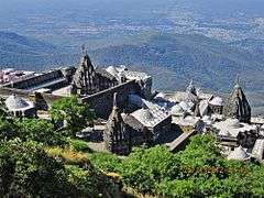
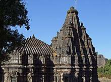
On entering the gate, the large enclosure of the temples is on the left, while to the right is the old granite temple of Man Singh, Bhoja Raja of Kutch, and farther on the much larger one of Vastupala. Built into the wall on the left of the entrance is an inscription in Sanskrit. Some 16 Jain temples here form a sort of fort on the ledge at the top of the great cliff, but still 600 feet below the summit. The largest temple is the Neminath temple, standing in a quadrangular court 195 x 130 feet. It was built from 1128 to 1159. It consists of two halls (with two porches, called the mandapas), and a shrine, which contains a large black image of Neminatha, the 22d Tirthankara. Around the shrine is a passage with many images in white marble. Between the outer and inner halls are two shrines. The outer hall has two small raised platforms paved with slabs of yellow stone, covered with representations of feet in pairs called padukas, which represent the 2452 feet of the Ganadharas, first disciples of Tirthankaras. On the west of this is a porch overhanging the perpendicular scarp. On two of the pillars of the mandapam are inscriptions dated 1275, 1281, and 1278—dates of restoration. The enclosure is nearly surrounded inside by 70 cells, each enshrining a marble image, with a covered passage in front of them lighted by a perforated stone screen.
The principal entrance was originally on the east side of the court, but it is now closed, and the entrance from the court in Khengar's Palace is that now used. There is a passage leading into a low dark temple, with granite pillars in lines. Opposite the entrance is a recess containing two large black images; in the back of the recess is a lion rampant, and over it a crocodile in bas-relief. Behind these figures is a room from which is a descent into a cave, with a large white marble image which is mostly concealed by priests. It has a slight hollow in the shoulder, said to be caused by water dropping from the ear, whence it was called Amijhara, "nectar drop."[3] Neminath is said to have attained Moksha from Girnar so this place is frequently noted in Jain literature.[7]
In the North porch are inscriptions which state that in Samwat 1215 certain Thakurs completed the shrine, and built the Temple of Ambika.
After leaving this there are three temples to the left that on the south side contain a colossal image of Rishabha Deva, the first Tirthankar, exactly like that at Palitana temples, called Bhim-Padam. On the throne of this image is a slab of yellow stone carved in 1442, with figures of the 24 Tirthankars.[3]
Opposite this temple is a modern one to Panchabai. West of it is a large temple called Malakavisi or Meravasi, sacred to Parshwanath, built in the 15th century. North of this is another temple of Parshwanath, which contains a large white marble image canopied by a cobra, whence it is called Sheshphani, an arrangement frequently found in the South India but uncommon in North India. It bears a date of 1803. The last temple to the north is Kumarpal's temple, built by Chaulukya king Kumarapala, which has a long open portico on the west. It appears to have been destroyed by the Muslims, and restored in 1824 by Hansraja Jetha. These temples are along the west face of the hill, and are all enclosed.[3]
Outside to the north is the Bhima Kunda, a tank 70 feet by 50 feet, in which Hindus bathe. Immediately behind the temple of Neminath is the triple one temple, Vastupala-Tejpala temple, erected by the brothers Tejapala and Vastupala (built in 1177), who also built the Dilwara Temples on Mount Abu. The plan is that of three temples joined together. The shrine has a blue black image of Mallinath, the 19th Tirthankar. Farther north is the temple of Samprati Raja, This temple is probably one of the oldest on the hill, dating to 1158. Samprati is said to have ruled at Ujjain in the end of the third century BCE, and to have been the son of Kunala, Ashoka's third son.[3]
Further trek
.jpg)


South of this, is the Gaumukhi Shrine, near a plentiful spring of water.[3]
From it the crest of the mountain (3330 feet) is reached by a steep flight of stairs. Here is an ancient temple of Amba Mata, which is much resorted to by newly married couples . The bride and bridegroom have their clothes tied together, and attended by their male and female relations, adore the goddess and present cocoa-nuts and other offerings. This pilgrimage is supposed to procure for the couple along continuance of wedded bliss.[3]
Festivals

The main event for Hindus is the Maha Shivaratri fair held every year on the 14th day of the Hindu calendar month of Magha. At least 1 million pilgrims visit the fair to participate in pooja and parikrama of Girnar hill. The procession begins at Bhavnath Mahadev Temple at Bhavnath. It then proceeds onwards to various akharas of various sects of sadhus, which are in Girnar hill from ancient times. The procession of sadhus and pilgrims ends again at Bhavnath temple after visiting Madhi, Malavela and Bara Devi temple. The fair begins with hoisting of fifty-two Gaja long flags at Bhavnath Mahadev temple. This fair is the backbone of the economy of Junagadh, as more than ten lakh pilgrims who visit the fair generate a revenue of 250 million in only five days.[8][9][10][11]
Religious disputes
The dispute regarding illegal construction around a shrine on the fifth tonk (peak) of Girnar mountain in Junagadh had landed before the Gujarat high court. A trust of the Digambar Jain sect had alleged illegal construction around the idol and charan (footprint) of Neminatha, in a manner that devotees could not see and worship the idol and footprint at the site.[12]

A controversy over ownership of a religious site on Girnar in Junagadh town saw a Hindu sadhu allegedly stabbing a Jain monk.[13] Police sources said victim Muni Shree Prabal Sagarji Maharaj of Udaipur in Rajasthan was taken to a private hospital for the treatment as he had received serious injuries on chest and abdomen. Accused Muktanand Giri was arrested by the police after a case was registered against him at Junagadh taluka police station.[13] Giri stabbed Prabal Sagarji with a knife when the latter arrived at Kamalkund.[13] The dispute over the engraved stone idol and footprint on the fifth peak of Girnar goes back several years.[12] “We have raised the issue about construction of concrete platform and grill in such a manner that Jains cannot see and offer prayer to the footprint of Neminath,” said HR Prajapati, counsel for petitioner Bharatvarshiya Digambar Jain Trith Kshetra Committee.[12]There was a clear high court order in 2005 that prohibited any new construction at the site but it was constructed by overlooking the order,” the counsel said. The archaeological department had concluded that illegal construction had taken place at the site. The matter of illegal construction around the monument had come before the Gujarat high court in 2004. After hearing all parties, the high court in 2005 had directed the Hindu Mahants to not undertake further illegal construction at the site.
It is claimed by Hindus that many images of Hindu gods and goddesses have been replaced by Jains from the Raa Khengar Mahal, ruins of an ancient palace, with carved images of Jain gods, to give an impression that Girnar is essentially a Jain place of pilgrimage. [14]However, these claims seems to be absurd as the main temple of lord Neminatha is made out of a single rock and the temple and idols both are ancient and have mentions in Shatrunjay Mahatmya and similar ancient texts.
The matter of illegal construction around the monument had come before the Gujarat high court in 2004. After hearing all parties, the high court in 2005 had directed the Hindu Mahants to not undertake further illegal construction at the site.[12]
Gallery
- lord Neminath temple
 Samprati Raja temple
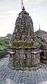 Temple view From About 3100 feet at Mt. Girnar
 Ambika Mata temple
 Chaumukhji Temple
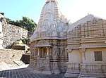 Vastupala Vihara
 Inscription of the Vastupala-vihara on Mount Girnar
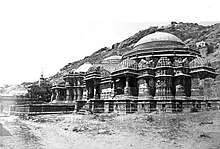 1876 image of Vastupala Vihara Jain temple on Girnar
.jpg) King Samprati's Tunk
King Samprati's Tunk
See also
References
- R. N. Sukheswala (January 1982). "Igneous Complex of Mount Girnar, Saurashtra, Gujarat - A Reappraisal". Journal of the Geological Society of India. 23 (1).
- Mihir K. Bose (January 1973). "Petrology and geochemistry of the igneous complex of Mount Girnar, Gujarat, India". Bose, M.K. Contr. Mineral. And Petrol. (1973) 39: 247. 39 (3): 247–266. Bibcode:1973CoMP...39..247B. doi:10.1007/BF00383107. ISSN 0010-7999.
- Murray, John (1911). "A handbook for travellers in India, Burma, and Ceylon". Internet Archive. pp. 155–157. Retrieved 28 January 2016.
- Keay, John (2000). India, a History. New York, United States: Harper Collins Publishers. pp. 129–131. ISBN 978-0-00-638784-8.CS1 maint: ref=harv (link))
- "Roof over Ashoka rock edicts in Junagadh crashes". The Times of India. 19 July 2014. Retrieved 21 March 2016.
- Inscriptions of Asoka. New Edition by E. Hultzsch (in Sanskrit). 1925. p. 3.
- M A Dhaky, Jitendra B Shah, સાહિત્ય શિલ્પ અને સ્થાપત્યમાં ગીરનાર, L D Indology, 2010
- "બાવન ગજની ધ્વજાનાં આરોહણ સાથે આજથી મહાશિવરાત્રિ મેળો Shivaratri fair begins today with hoisting of 52 gaja dwaja". Sandesh. 16 February 2012. Retrieved 22 August 2012.
- "ગિરનાર ઃ લીલી પરિક્રમા ઃ પરકમ્મા Girnar - Lili Parikrama". Gujarat Samachar. 4 August 2012. Archived from the original on 10 October 2012. Retrieved 22 August 2012.
- "જૂનાગઢની આર્થિક કરોડરજજુ શિવરાત્રિનો મેળો : પાંચ દિવસમાં રૂ.રપ કરોડનો લાભ Junagadh's economic backbone - Girnar Shivaratri fair - generates income of 25 crores in five days". Sandesh. 18 February 2012. Archived from the original on 23 December 2007. Retrieved 22 August 2012.
- "My Experience of Girnar Parikrama 2011 - SpeakBindas". www.speakbindas.com.
- Correspondent, DNA (10 January 2013). "Jain trust files plea in HC over Girnar shrine row". DNA India. Archived from the original on 20 October 2019. Retrieved 29 July 2019.
- Jan 3, TNN | Updated; 2013; Ist, 12:23. "Sadhu assaults monk on Mt Girnar | Rajkot News - Times of India". The Times of India. Archived from the original on 20 October 2019. Retrieved 29 July 2019.CS1 maint: numeric names: authors list (link)
- Conflict between Hindus, Jains over sacred sites on Mount Girnar mounts
| Topics |  | |
|---|---|---|
| Regions of Gujarat | ||
| Districts | ||
| Major cities | ||
| Ecoregions | ||
| Economy |
| |
| ||
| Edicts of Ashoka (Ruled 269–232 BCE) | |||||
| Regnal years of Ashoka |
Type of Edict (and location of the inscriptions) |
Geographical location | |||
| Year 8 | End of the Kalinga war and conversion to the "Dharma" |  Udegolam Nittur Brahmagiri Jatinga Rajula Mandagiri Yerragudi Sasaram Barabar Kandahar (Greek and Aramaic) Kandahar Khalsi Ai Khanoum (Greek city) | |||
| Year 10[1] | Minor Rock Edicts | Related events: Visit to the Bodhi tree in Bodh Gaya Construction of the Mahabodhi Temple and Diamond throne in Bodh Gaya Predication throughout India. Dissenssions in the Sangha Third Buddhist Council In Indian language: Sohgaura inscription Erection of the Pillars of Ashoka | |||
| Kandahar Bilingual Rock Inscription (in Greek and Aramaic, Kandahar) | |||||
| Minor Rock Edicts in Aramaic: Laghman Inscription, Taxila inscription | |||||
| Year 11 and later | Minor Rock Edicts (n°1, n°2 and n°3) (Panguraria, Maski, Palkigundu and Gavimath, Bahapur/Srinivaspuri, Bairat, Ahraura, Gujarra, Sasaram, Rajula Mandagiri, Yerragudi, Udegolam, Nittur, Brahmagiri, Siddapur, Jatinga-Rameshwara) | ||||
| Year 12 and later[1] | Barabar Caves inscriptions | Major Rock Edicts | |||
| Minor Pillar Edicts | Major Rock Edicts in Greek: Edicts n°12-13 (Kandahar) Major Rock Edicts in Indian language: Edicts No.1 ~ No.14 (in Kharoshthi script: Shahbazgarhi, Mansehra Edicts (in Brahmi script: Kalsi, Girnar, Sopara, Sannati, Yerragudi, Delhi Edicts) Major Rock Edicts 1-10, 14, Separate Edicts 1&2: (Dhauli, Jaugada) | ||||
| Schism Edict, Queen's Edict (Sarnath Sanchi Allahabad) Lumbini inscription, Nigali Sagar inscription | |||||
| Year 26, 27 and later[1] |
Major Pillar Edicts | ||||
| In Indian language: Major Pillar Edicts No.1 ~ No.7 (Allahabad pillar Delhi pillar Topra Kalan Rampurva Lauria Nandangarh Lauriya-Araraj Amaravati) Derived inscriptions in Aramaic, on rock: | |||||
| Wikiquote has quotations related to: Girnar |