Gandhinagar district
Gandhinagar district is an administrative division of Gujarat, India, whose headquarters are at Gandhinagar, the state capital. It was organized in 1964.
Gandhinagar district | |
|---|---|
district | |
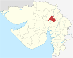 Location of district in Gujarat | |
| Country | |
| State | Gujarat |
| Headquarters | Gandhinagar |
| Area | |
| • Total | 2,163 km2 (835 sq mi) |
| Population (2011) | |
| • Total | 1,391,753 |
| Languages | |
| • Official | Gujarati, Hindi, English |
| Time zone | UTC+5:30 (IST) |
| Vehicle registration | GJ 18 |
| Website | gandhinagar |
It has an area of 649 km², and a population of 1,391,753 of which 35.02% were urban (2001 census).[1] The district includes Gandhinagar with three Suburbs - Motera, Adalaj. The four tehsils are - Gandhinagar, Kalol INA, Dahegam and Mansa - and 216 villages.
Gandhinagar district is bounded by the districts of Sabarkantha and Aravalli to the northeast, Kheda to the southeast, Ahmedabad to the southwest, and Mehsana to the northwest.
Connected to Ahmedabad by the Sarkhej-Gandhinagar highway, and with Vadodara with the Ahmedabad-Vadodara highway, these three cities form the top population centres and commercial heart of Gujarat and western India.
Gandhinagar city is a planned city that has 30 sectors, 1 km each in length and width. Each sector has a primary school, a secondary school, a higher secondary school, a medical dispensary, a shopping centre and a maintenance office.
Gandhinagar has infocity nearby which is housing IT companies. Many big IT companies like TCS, Cybage has presence in infocity whereas PCS is located at GIDC area. Many more companies are planning to come to infocity. Etech, Inc., one of the major BPO players in Gujarat is also based here along with operations in Vadodara and Texas.[2]
Akshardham Gandhinagar is situated in Sector-20. It is one of the major Hindu Temple complex of Gujarat.
Gandhinagar has many educational institutions. With 87.11% its education level is highest in Gujarat.
Demographics
According to the 2011 census Gandhinagar district has a population of 1,391,753,[3] roughly equal to the nation of Swaziland[4] or the US state of Hawaii.[3][5] The district has a population density of 660 inhabitants per square kilometre (1,700/sq mi) .[3] Its population growth rate over the decade 2001-2011 was 12.15%.[3] Gandhinagar has a sex ratio of 920 females for every 1000 males,.[3] It had a literacy rate of 76.5% in 2001 which rose by an impressive 10 percentage points in 10 years to literacy rate of 85.78% in 2011.[3]
At the time of the 2011 Census of India, 93.94% of the population in the district spoke Gujarati and 4.56% Hindi as their first language.[6]
| Historical population | ||
|---|---|---|
| Year | Pop. | ±% p.a. |
| 1901 | 222,527 | — |
| 1911 | 225,592 | +0.14% |
| 1921 | 242,815 | +0.74% |
| 1931 | 268,801 | +1.02% |
| 1941 | 327,493 | +1.99% |
| 1951 | 401,815 | +2.07% |
| 1961 | 478,611 | +1.76% |
| 1971 | 648,666 | +3.09% |
| 1981 | 835,337 | +2.56% |
| 1991 | 1,016,339 | +1.98% |
| 2001 | 1,237,168 | +1.99% |
| 2011 | 1,391,753 | +1.18% |
| source:[7] | ||
Tourism
A blend of heritage, history and culture, Gandhinagar is one of the most harmonious city that one can ever visit. A home to the Akshardham Temple that is adorned with pink stone and beautiful carving, Gandhinagar also houses:[8]
- Swaminarayan Temple
- Sarita Udyan
- Capital Complex
- Hanumanji Temple
- Children's Park
- Indroda Dinosaur and Fossil Park
- Mahatma Mandir
- Blackbuck National Park
- Rani Roopmatis Mosque
References
- "Archived copy". Archived from the original on 2007-07-03. Retrieved 2009-08-27.CS1 maint: archived copy as title (link)
- http://www.etechinc.com/
- "District Census 2011". Census2011.co.in. 2011. Retrieved 2011-09-30.
- US Directorate of Intelligence. "Country Comparison:Population". Retrieved 2011-10-01.
Swaziland 1,370,424
- "2010 Resident Population Data". U. S. Census Bureau. Archived from the original on 2011-01-01. Retrieved 2011-09-30.
Hawaii 1,360,301
- 2011 Census of India, Population By Mother Tongue
- Decadal Variation In Population Since 1901
- "Gandhinagar Travel Guide, Gujarat". Tour My India.
External links
| Wikimedia Commons has media related to Gandhinagar district. |
Places adjacent to Gandhinagar district | ||||||||||
|---|---|---|---|---|---|---|---|---|---|---|
| ||||||||||
| Topics | 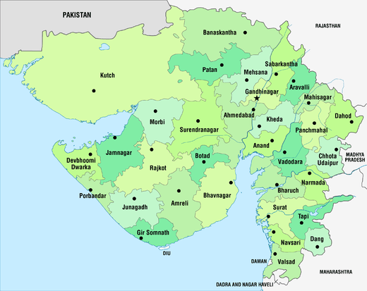 | |
|---|---|---|
| Regions of Gujarat | ||
| Districts | ||
| Major cities | ||
| Ecoregions | ||
| Economy |
| |
| ||