Junagadh district
Junagadh District is a district of the Indian state of Gujarat. Its administrative headquarters is the city of Junagadh.
Junagadh district | |
|---|---|
district | |
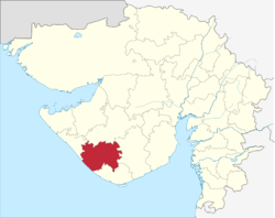 Location of district in Gujarat | |
| Coordinates: 21°31′N 70°27′E | |
| Country | |
| State | Gujarat |
| Region | Saurashtra |
| Headquarters | Junagadh |
| Area | |
| • Total | 8,831 km2 (3,410 sq mi) |
| Population (2011) | |
| • Total | 2,743,082 |
| • Density | 310/km2 (800/sq mi) |
| Languages | |
| • Official | Gujarati, Hindi |
| Time zone | UTC+5:30 (IST) |
| PIN | 362001 |
| Vehicle registration | GJ 11 |
| Website | http://junagadh.gujarat.gov.in/ |
Geography
The district is located on the Kathiawar peninsula in western Gujarat. It is surrounded by Rajkot District (North), Porbandar District (North-West), Amreli District (East). To the South and West is the Arabian Sea.
Porbandar, Mahatma Gandhi's birthplace, was earlier a part of this district, before the Porbandar district was carved out of Junagadh district.
Junagadh has a mountain range called Girnar which is a place of pilgrimage for Hinduism and Jainism.
Divisions
Talukas of Junagadh are: Junagadh City, Bhesan subdistrict,[1] Junagadh Rural, Keshod, Malia, Manavadar, Mangrol, Mendarda, Vanthali, Visavadar
Transportation
Junagadh is well connected by road and railway networks. It is about 100 km from Rajkot and 350 km from Ahmedabad. National highway 8D connects Junagadh to Rajkot via Jetpur.
Junagadh railway station is also well connected with Rajkot, Ahmedabad. It is in the city area. Junagadh also has an airport at Keshod which has limited connectivity with Mumbai.
The district has a long shore line and has ports like Veraval, Mangrol, Chorwad etc. But it has limited usages other than fisheries industry.
As of October 2011, the government of India has given its approval for a rope way on Mount Girnar. However it will take a lot of time to develop it. In the past helicopter service was available for Mount Girnar but it is now discontinued.
Demographics
| Historical population | ||
|---|---|---|
| Year | Pop. | ±% p.a. |
| 1901 | 415,521 | — |
| 1911 | 458,829 | +1.00% |
| 1921 | 491,969 | +0.70% |
| 1931 | 579,792 | +1.66% |
| 1941 | 729,508 | +2.32% |
| 1951 | 829,760 | +1.30% |
| 1961 | 1,051,074 | +2.39% |
| 1971 | 1,408,342 | +2.97% |
| 1981 | 1,813,780 | +2.56% |
| 1991 | 2,091,182 | +1.43% |
| 2001 | 2,448,173 | +1.59% |
| 2011 | 2,743,082 | +1.14% |
| source:[2] | ||
According to the 2011 census Junagadh district has a population of 2,743,082,[3] roughly equal to the nation of Jamaica[4] or the US state of Utah.[5] This gives it a ranking of 142nd in India (out of a total of 640).[3] The district has a population density of 310 inhabitants per square kilometre (800/sq mi).[3] Its population growth rate over the decade 2001–2011 was 12.01%.[3] Junagadh has a sex ratio of 952 females for every 1000 males.[3] It had a literacy rate of 67.7% in 2001 which increased to a literacy rate of 76.88% in 2011.[3]
At the time of the 2011 Census of India, 96.84% of the population in the district spoke Gujarati, 1.25% Hindi, 0.99% Sindhi and 0.59% Urdu as their first language.[6]
Notable personalities
- Narsinh Mehta (1414?–1481?), poet-saint, born in Talaja, Bhavnagar district.
- Wazir Mohammad (1929–), cricketer, born at Junagadh, later settled in Pakistan
- Dhirubhai Ambani (1932–2002), business magnate and entrepreneur, born at Chorwad, Junagadh
- Hanif Mohammad (1934–2016), cricketer, born at Junagadh, settled in Pakistan after 1947
- Rajendra Shukla (1942–), poet, born at Bantwa, Junagadh
- Mushtaq Mohammad (1943–), cricketer, born at Junagadh, later settled in Pakistan
- Sadiq Mohammad (1945–), cricketer, born at Junagadh, later settled in Pakistan
- Parveen Babi (1949–2005), Bollywood actress, born at Junagadh
- Nawab Muhammad Mahabat Khan
Flora and fauna
Junagadh contains the Gir Forest National Park, which is the only home to Asiatic lions. Mount Girnar is also declared a forest reserve for Bamboos. "Girnari Giddh", the long-billed vultures, are found only on Girnar, as the Girnar region alone accounts for about 25 per cent of the species and about 10 per cent of the total vulture population in the Gujarat State.
Education
Junagadh Agricultural University is majorly famous here. There are so many other educational institutes here like:
- N R Vekaria Institutes of Business Management Studies
- Amrut Institute, Junagadh
- http://www.bknmu.edu.in/
References
- "Bhesan". 2011 Census of India. Government of India. Archived from the original on 28 November 2017. Retrieved 1 December 2017.
- Decadal Variation In Population Since 1901
- "Junagadh District Population - Census 2011". CensusIndia.co.in.
- US Directorate of Intelligence. "Country Comparison:Population". Retrieved 2011-10-01.
Jamaica 2,868,380 July 2011 est
- "2010 Resident Population Data". U. S. Census Bureau. Archived from the original on 2011-01-01. Retrieved 2011-09-30.
Utah 2,763,885
- 2011 Census of India, Population By Mother Tongue
External links
| Wikimedia Commons has media related to Junagadh district. |
Places adjacent to Junagadh district | |
|---|---|
| Topics |  | |
|---|---|---|
| Regions of Gujarat | ||
| Districts | ||
| Major cities | ||
| Ecoregions | ||
| Economy |
| |
| ||