Porbandar district
Porbandar district is one of the 33 districts of Gujarat state in western India. The district covers an area of 2,316 km². It had a population of 5.85,449 of which 48.77% were urban as of 2011 census [1] This district was carved out of Junagadh District. It lies on the Kathiawar peninsula. Porbandar city is the administrative headquarters of this district. This district is surrounded by Jamnagar district and Devboomi Dwarka to the north, Junagadh district and Rajkot district to the east and the Arabian Sea to the west and south.
Porbandar District પોરબંદર જિલ્લો(Gujarati)
पोरबन्दर जिल्ला(जिल्लो) (Sanskrit , Hindi , SindhiDevanagari) پوربندر ضلعو(Sindhi) | |
|---|---|
District | |
| Nickname(s): PBR | |
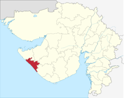 Location of Porbandar district in Gujarat | |
| Country | |
| State | Gujarat |
| Region | Saurashtra |
| Headquarters | Porbandar |
| Area | |
| • Total | 2,316 km2 (894 sq mi) |
| Population (2011) | |
| • Total | 585,449 |
| • Density | 250/km2 (650/sq mi) |
| Languages | |
| • Official | Gujarati , Hindi , Sindhi |
| Time zone | UTC+5:30 (IST) |
| Vehicle registration | GJ-25 |
| Website | porbandar |
As of 2011 it is the second least-populous district of Gujarat (out of 33), after Dang.[2]
History
Porbandar is the birthplace of Mahatma Gandhi. Porbandar is also mentioned in the Mahabharata as the native place of Krishna's childhood friend Sudama.
Economy
Demographics
| Historical population | ||
|---|---|---|
| Year | Pop. | ±% p.a. |
| 1901 | 106,925 | — |
| 1911 | 118,346 | +1.02% |
| 1921 | 127,697 | +0.76% |
| 1931 | 150,852 | +1.68% |
| 1941 | 190,429 | +2.36% |
| 1951 | 216,450 | +1.29% |
| 1961 | 270,634 | +2.26% |
| 1971 | 354,094 | +2.72% |
| 1981 | 425,899 | +1.86% |
| 1991 | 469,472 | +0.98% |
| 2001 | 536,835 | +1.35% |
| 2011 | 585,449 | +0.87% |
| source:[3] | ||
According to the 2011 census Porbandar district has a population of 585,449,[2] roughly equal to the nation of Solomon Islands[4] or the US state of Wyoming.[5] This gives it a ranking of 529th in India (out of a total of 640).[2]
The district has a population density of 255 inhabitants per square kilometre (660/sq mi).[2] Its population growth rate over the decade 2001-2011 was 9.17%.[2] Porbandar has a sex ratio of 947 females for every 1000 males,[2] and a literacy rate of 76.63%.[2]
At the time of the 2011 Census of India, 96.76% of the population in the district spoke Gujarati, 1.32% Hindi, 1.06% Sindhi and 0.52% Urdu as their first language.[6]
Transportation
- Airport: Porbandar airport serving the city Mumbai & Ahmedabad by direct daily flight.
- Railway: Porbandar railway station connects porbandar to whole country
- Roads & Highways: N.H.-8B connects Porbandar to Rajkot
Notable personalities
- Mohandas Karamchand Gandhi (1869–1948) The pre-eminent political and ideological leader of India during the Indian independence movement. Born in Porbandar.[7]
- Vijaygupta Maurya (1909–1992) Science writer. Born in Porbandar.
- Dilip Joshi (playing the role of Jethalal Gada in Tarak Mehta Ka Ooltah Chashmah)
- Nanji Kalidas Mehta (Business Tycoon and a Grandfather-in-law of Juhi Chawla)
References
- Census India Map Archived 2010-01-11 at the Wayback Machine
- "District Census 2011". Census2011.co.in. 2011. Retrieved 2011-09-30.
- Decadal Variation In Population Since 1901
- US Directorate of Intelligence. "Country Comparison:Population". Retrieved 2011-10-01.
Solomon Islands 571,890 July 2011 est.
- "2010 Resident Population Data". U. S. Census Bureau. Retrieved 2011-09-30.
Wyoming 563,626
- 2011 Census of India, Population By Mother Tongue
- Fischer, Louis (1954). "Gandhi:His life and message for the world". Mentor. Cite journal requires
|journal=(help)CS1 maint: ref=harv (link)
External links
| Wikimedia Commons has media related to Porbandar district. |
Places adjacent to Porbandar district | ||||||||||
|---|---|---|---|---|---|---|---|---|---|---|
| ||||||||||
| Topics | 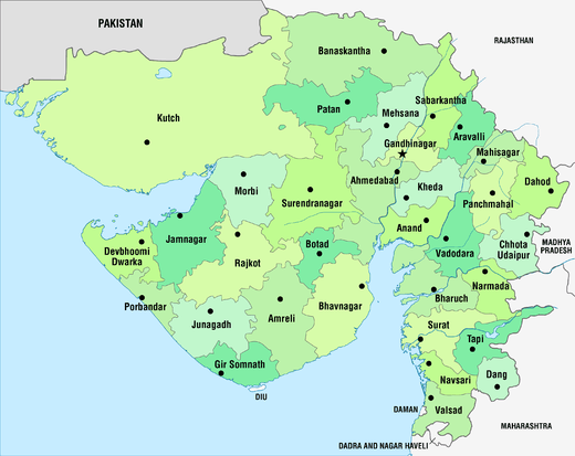 | |
|---|---|---|
| Regions of Gujarat | ||
| Districts | ||
| Major cities | ||
| Ecoregions | ||
| Economy |
| |
| ||