Dahod district
Dahod District is located in Gujarat state in western India, called after its administrative HQ. It has a population of 2,127,086 (2011 census), with a population density of 583 persons per km².
Dahod district | |
|---|---|
district | |
 Location of district in Gujarat | |
| Country | |
| State | Gujarat |
| Collector & DM | Shri Vijay Kharadi I.A.S. |
| Headquarters | Dahod |
| Area | |
| • Total | 3,642 km2 (1,406 sq mi) |
| Population (2011) | |
| • Total | 2,127,086 |
| • Density | 580/km2 (1,500/sq mi) |
| Languages | |
| • Official | Gujarati, Hindi, English |
| Time zone | UTC+5:30 (IST) |
| Vehicle registration | GJ 20 |
| Website | dahod |
Half of Dahod's population is rural, and 74.3% of the population is scheduled tribes.[1] Dahod has a literacy rate of 58.82%, which is lower than all other districts in Gujarat.[2]
History
Dahod District was created on 2 October 1997, and was formerly part of Panchmahal District. Its territory mostly consists of two former Princely States, namely Baria (Devgadh) and Sanjeli, in addition to Fatehpura Taluka of Sunth (Rampur), along with the two "eastern mahals" of Dahod and Jhalod from the former Panch Mahals.
Population
| Historical population | ||
|---|---|---|
| Year | Pop. | ±% p.a. |
| 1901 | 177,555 | — |
| 1911 | 229,553 | +2.60% |
| 1921 | 267,075 | +1.53% |
| 1931 | 317,838 | +1.76% |
| 1941 | 365,700 | +1.41% |
| 1951 | 437,189 | +1.80% |
| 1961 | 580,397 | +2.87% |
| 1971 | 742,363 | +2.49% |
| 1981 | 946,588 | +2.46% |
| 1991 | 1,274,123 | +3.02% |
| 2001 | 1,636,433 | +2.53% |
| 2011 | 2,127,086 | +2.66% |
| source:[3] | ||
It was 8.99% urban at the 2001 census.[5] The population of the district is mostly rural, and a majority of the district's residents are Tribals, mostly Bhils. Dahod District also has the second largest population of the Dawoodi Bohra sect of Ismā'īlī Muslims in India.
At the 2011 census Dahod District had a population of 2,127,086,[6] roughly equal to the nation of Namibia[7] or the US state of New Mexico.[8] It was the 215th most populous district in India (out of a total of 640).[6] The district had a population density of 582 inhabitants per square kilometre (1,510/sq mi).[6] Its population growth rate over the decade 2001–2011 was 29.95%.[6] It had a sex ratio of 986 females for every 1000 males,[6] and a literacy rate of 60.6%.[6]
At the time of the 2011 Census of India, 96.29% of the population in the district spoke Gujarati, 2.14% Bhili and 1.22% Hindi as their first language.[9]
Geography
This district is bounded by Panchmahal District to the west, Chhota Udaipur district to the south, Jhabua District and Alirajpur District of Madhya Pradesh State to the east and southeast respectively, and Banswara District of Rajasthan State to the north and northeast. The city of Dahod is the district's administrative headquarters. The district has an area of 3,642 km². The national highway 59 is passing through the district, which connects chittorgarh of Rajasthan and Dahod. The actual name is "Dohad", which later got transformed into Dahod. The Mughal Emperor Aurangzeb was born in a mosque within the fort of Dahod.
The district is sub-divided into the following Talukas (Tehsils) :
Education
There is a government polytechnic college since 1963 and it was started by Indian prime minister Mr. Moraraji Desai and now government degree engineering college[10] is also there. The degree college is affiliated to Gujarat University.
Economy
In 2006 the Ministry of Panchayati Raj named Dahod one of the country's 250 most backward districts (out of a total of 640).[11] It is one of the six districts in Gujarat currently receiving funds from the Backward Regions Grant Fund Programme (BRGF).[11]
Ratan Mahal Sanctuary
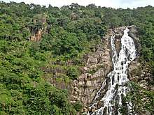
It is a mixed, deciduous forest, located at Gujarat's border with Madhya Pradesh, within the Khathiar-Gir dry deciduous forests' ecoregion.[12] The maximum area covered is in Gujarat. Ratanmahal Sanctuary is near by River Paanam (a major river of Central Gujarat), which helps to preserve the ecological balance in the forest, besides water conservation. The sanctuary is also known as "Ratanmahal Sloth Bear Sanctuary," due to its sloth bear population.[13] As with Purna Wildlife Sanctuary, Ratanmahal has experienced extinctions in its population of birds.[14]
See also
- Forest of the Dangs
- Jessore Sloth Bear Sanctuary
- Shoolpaneshwar Wildlife Sanctuary
References
- "Dahod District Population, Caste, Religion Data (Gujarat) – Census 2011". Census 2011.
- "Districts of Gujarat". Census 2011.
- Decadal Variation In Population Since 1901
- Dohad (Dahod) District Population Census 2011, Gujarat literacy sex ratio and density
- "India Map". Archived from the original on 2007-07-03. Retrieved 2009-08-27.
- "District Census 2011". Census2011.co.in. 2011. Retrieved 2011-09-30.
- US Directorate of Intelligence. "Country Comparison:Population". Retrieved 2011-10-01.
Namibia – 2,147,585
- "2010 Resident Population Data". U.S. Census Bureau. Archived from the original on 2013-10-19. Retrieved 2011-09-30.
New Mexico – 2,059,179
- 2011 Census of India, Population By Mother Tongue
- "Archived copy". Archived from the original on 2012-05-02. Retrieved 2019-11-19.CS1 maint: archived copy as title (link)
- Ministry of Panchayati Raj (September 8, 2009). "A Note on the Backward Regions Grant Fund Programme" (PDF). National Institute of Rural Development. Archived from the original (PDF) on April 5, 2012. Retrieved September 27, 2011.
- "Khathiar-Gir dry deciduous forests". Terrestrial Ecoregions. World Wildlife Fund. Retrieved 2017-02-14.
- Garshelis, David L.; Joshi, Anup R.; Smith, James L. D. & Rice, Clifford G. "Sloth Bear Conservation Action Plan" (PDF). Archived from the original (PDF) on 23 July 2011. Retrieved 18 April 2011.
- "Significant bird records and local extinctions in Purna and Ratanmahal Wildlife Sanctuaries, Gujarat, India-PRANAV TRIVEDI and V. C. SONI" (PDF). Archived from the original (PDF) on 2017-08-10. Retrieved 2019-06-18.
External links
| Wikimedia Commons has media related to Dahod district. |
Places adjacent to Dahod district | ||||||||||
|---|---|---|---|---|---|---|---|---|---|---|
| ||||||||||
| Topics | 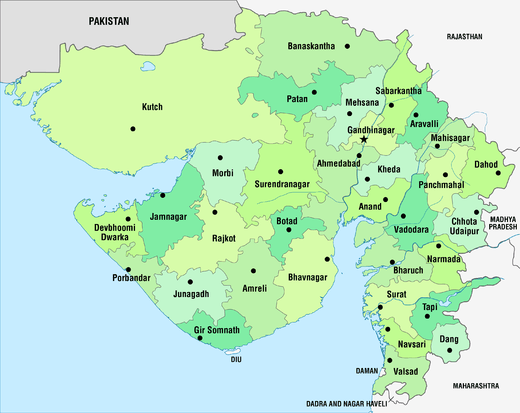 | |
|---|---|---|
| Regions of Gujarat | ||
| Districts | ||
| Major cities | ||
| Ecoregions | ||
| Economy |
| |
| ||