Nowra, New South Wales
Nowra /ˈnaʊərə/ is a town in the South Coast region of New South Wales, Australia. It is located 160 kilometres (99 mi) south-southwest of the state capital of Sydney (about 120 kilometres (75 mi) as the crow flies.) With its twin-town of Bomaderry, as at June 2018, Nowra had an estimated population of 37,420.[1] It is also the seat and commercial centre of the City of Shoalhaven. Geologically, the city is situated in the southern reaches of the Sydney basin.[2]
| Nowra New South Wales | |||||||||||||||
|---|---|---|---|---|---|---|---|---|---|---|---|---|---|---|---|
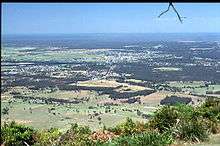
 Nowra area from Cambewarra Lookout | |||||||||||||||
Nowra | |||||||||||||||
| Coordinates | 34°53′S 150°36′E | ||||||||||||||
| Population | 37,420 (2018)[1] | ||||||||||||||
| • Density | 184.88/km2 (478.84/sq mi) | ||||||||||||||
| Established | 1852 | ||||||||||||||
| Area | 202.4 km2 (78.1 sq mi) | ||||||||||||||
| Time zone | AEST (UTC+10) | ||||||||||||||
| • Summer (DST) | AEDT (UTC+11) | ||||||||||||||
| Location | 160 km (99 mi) from Sydney | ||||||||||||||
| LGA(s) | City of Shoalhaven | ||||||||||||||
| State electorate(s) | South Coast | ||||||||||||||
| Federal Division(s) | Gilmore | ||||||||||||||
| |||||||||||||||
The region around Nowra is a farming community, sustaining a thriving dairy industry[3] and a number of State forests, but is also increasingly a retirement and leisure area for Canberra and Sydney. The naval air station HMAS Albatross is located about 10 kilometres (6.2 mi) south-west of Nowra. The name Nowra, originally written by Europeans as 'nou-woo-ro' (pronounced Nowa Nowa by the Indigenous Australians of the area), is an Aboriginal word for black cockatoo.[4]
History
The Nowra region, south of Bomaderry Creek was inhabited by the Wodi-Wodi tribe of the Yuin nation while north of Bomaderry Creek was inhabited by the Dharawal Aboriginal people prior to European arrival. Around 1824, ex-convict Mary Reibey applied for a land grant in the Burrier area, on the southern side of the Shoalhaven River. The Nowra township was officially recognised in 1852. Less than ten years later, in 1861, a postal service was established. Also in that year, the racehorse 'Archer', trained in Nowra by Etienne de Mestre, won the first Melbourne Cup. By 1885, Nowra was declared a town.[3]
A major landmark in the area is the house Bundanon, which began as a single-storey weatherboard structure built about 1840. In 1866, a two-storey sandstone house, made of locally quarried stone, was built immediately in front of the weatherboard house. The sandstone house features timber verandahs and is now listed on the Register of the National Estate.[5]
Heritage listings
Nowra has a number of heritage-listed sites, including:
- Pleasant Way: Graham Lodge[6]
- 35 West Street: Meroogal[7]
Geography
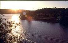
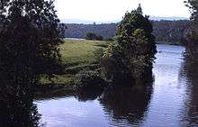
Nowra is on the Shoalhaven River, which formerly hosted the Australian National wakeboarding championships and is a popular fishing location. The river divides Nowra from Bomaderry and North Nowra, and is bridged by the historic Nowra Bridge. The Shoalhaven River is a salt water river, although the river itself does not flow into the sea. The Shoalhaven River meets the sea through the canal that joins the Shoalhaven and Crookhaven Rivers, which was dug by convicts under direction of local entrepreneur and pioneer Alexander Berry.
It is located near Berry, Jervis Bay, Kangaroo Valley, Culburra Beach, Greenwell Point, Huskisson, Shoalhaven Heads and Cambewarra.
Climate
With the warmest month's mean being just 22 °C (71.6 °F), Nowra has a humid subtropical climate (Cfa) under the Köppen climate classification, making it the southernmost city on the coastal strip to be within this climate zone, albeit an isolated one — nearby coastal cities to the north, such as Wollongong and Kiama, have an oceanic climate (Cfb) as their warmest month's mean does not reach the 22 °C threshold.[8]
| Climate data for Nowra (HMAS Albatross), elevation: 109 m, averages 2000-2019 | |||||||||||||
|---|---|---|---|---|---|---|---|---|---|---|---|---|---|
| Month | Jan | Feb | Mar | Apr | May | Jun | Jul | Aug | Sep | Oct | Nov | Dec | Year |
| Record high °C (°F) | 45.1 (113.2) |
40.5 (104.9) |
37.6 (99.7) |
34.6 (94.3) |
27.4 (81.3) |
23.3 (73.9) |
24.7 (76.5) |
26.6 (79.9) |
33.2 (91.8) |
37.1 (98.8) |
41.2 (106.2) |
43.0 (109.4) |
45.1 (113.2) |
| Average high °C (°F) | 27.6 (81.7) |
26.3 (79.3) |
25.2 (77.4) |
22.7 (72.9) |
19.6 (67.3) |
16.9 (62.4) |
16.6 (61.9) |
18.2 (64.8) |
21.1 (70.0) |
23.2 (73.8) |
24.7 (76.5) |
25.9 (78.6) |
22.3 (72.1) |
| Average low °C (°F) | 16.5 (61.7) |
16.7 (62.1) |
15.1 (59.2) |
12.3 (54.1) |
9.2 (48.6) |
7.8 (46.0) |
6.6 (43.9) |
6.8 (44.2) |
8.8 (47.8) |
10.6 (51.1) |
13.5 (56.3) |
14.8 (58.6) |
11.6 (52.9) |
| Record low °C (°F) | 8.6 (47.5) |
9.5 (49.1) |
7.7 (45.9) |
3.7 (38.7) |
3.0 (37.4) |
2.5 (36.5) |
−0.5 (31.1) |
−0.9 (30.4) |
2.5 (36.5) |
2.7 (36.9) |
5.7 (42.3) |
7.4 (45.3) |
−0.9 (30.4) |
| Average rainfall mm (inches) | 65.8 (2.59) |
132.6 (5.22) |
98.6 (3.88) |
67.9 (2.67) |
52.5 (2.07) |
121.4 (4.78) |
64.7 (2.55) |
72.7 (2.86) |
42.5 (1.67) |
66.7 (2.63) |
72.2 (2.84) |
79.9 (3.15) |
901.5 (35.49) |
| Average rainy days | 10.8 | 11.8 | 12.4 | 12.1 | 9.2 | 11.9 | 10.0 | 8.1 | 8.9 | 9.7 | 12.1 | 10.5 | 127.5 |
| Average afternoon relative humidity (%) | 57 | 63 | 59 | 57 | 55 | 56 | 53 | 46 | 47 | 52 | 56 | 55 | 55 |
| Source: BOM[9] | |||||||||||||


Demographics
The population of Nowra - Bomaderry was 37,420 at June 2018;[1] having grown gradually since 2005 when the population was 31,716.[10]
According to the 2006 census, 87.9% of the population of Nowra was born in Australia, with North-West Europe being the most common birthplace of immigrants at 7.5% of the population. 6.1% of the total population are Indigenous Australians. There are 11,386 households in Nowra. There are a total of 8,248 families, with 2,838 containing two Adults with children under 15 and/or dependent students, and 1,163 being one parent families with children under 15 and/or dependent students.[11]
The suburb of Nowra[12][13] had a population of 9,193 at the 2016 census.[14]
Economy
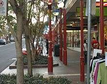
In the Nowra-Bomaderry area there are several schools. Nowra Town Hall (built in 1948) is in the CBD which provides many services including banks, health services and library. There is a large retirement population with several village options in the area. Nowra has a growing tourist industry, especially in the summer months, when visitors (mostly from Sydney and Canberra) flock to the beaches, to enjoy swimming, surfing, fishing, relaxing in the restaurants and cafés and hunting for treasures in the shops and boutiques.
Nowra sits in the Shoalhaven region where there are several vineyards producing award-winning wines.
Education
Nowra has three public high schools, Nowra High School, Shoalhaven High School and Bomaderry High School. There are also several non-government schools, which are all denominational; a K-12 Christian-based school located in South Nowra, Nowra Christian School; a K-12 Anglican college in Bomaderry, Nowra Anglican College; and a Catholic systemic high school, St John the Evangelist Catholic High School on the outskirts of Nowra.
The Catholic high school is linked to St Michael's Catholic Primary School located in Nowra. There are seven public primary schools in the Nowra area as well: East Nowra Public School, Nowra Public School, Bomaderry Public School, Illaroo Road Public School, North Nowra Public School, Nowra Hill Public School and Terara Public School.
The University of Wollongong also has a campus in Nowra, and there is a campus of TAFE NSW Illawarra Institute located in Bomaderry.
Health
There are two hospitals in Nowra, the Shoalhaven District Memorial Hospital, a hub for oncology services, and Nowra Private Hospital.
Sports
The four major codes of football in Australia are all popular in the Nowra area. Rugby union is represented by the Shoalhaven Rugby Club, the team plays out of Rugby Park in South Nowra. The club won the 2008 premiership in the Illawarra district competition, and has produced international and provincial players such as Andrew Walker and Alex Kanaar. Australian rules football is played by three clubs from the Shoalhaven area, with the Nowra Albatross Vikings playing at West Street Oval, and the Bomaderry Tigers at Artie Smith Oval. Further south, the Bay and Basin Bombers play at the Leisure Centre at Vincentia. These four clubs are all members of the South Coast AFL, fielding junior and senior teams. Rugby league has traditionally been represented by the Nowra Warriors and Bomaderry Swamprats. However, at the end of 2007 these teams merged to form the Shoalhaven Jets Rugby League Football Club. The Shoalhaven Mariners were established in 2006 and represent the area in the sport of baseball. The team plays home matches out of Fred Finch Park in Berkeley, Wollongong. Baseball has a new venue at the South Nowra Soccer Complex.[15] The Shoalhaven Tigers represent the area in the New South Wales State Basketball League and have won several championships from 1988 until 2007.
Archer was an Australian thoroughbred racehorse who won the first and the second Melbourne Cups in 1861 and 1862. He won both Cups easily, and is one of only five horses to have won the Melbourne Cup on two or more occasions, and one of only four horses to have won two successive Cups. Archer was trained in the Nowra area.
Public transport
Nowra Coaches operate services from Nowra to Bomaderry, Huskisson, Vincentia and Jervis Bay.[16] Shoal Bus operates services from Gerringong to Ulladulla.[17]
Although Nowra has no direct rail connection, the Illawarra railway line terminates at Bomaderry with NSW TrainLink operating services to Kiama and Sydney.[18]
Notable people
- Arthur Boyd, artist
- Tony Branson, Australian rugby league international
- Deborah Cheetham, Indigenous Australian opera singer.
- Ian Davis, Australian cricket international
- Jeff Dowdell, basketball (Cairns Taipans) player
- Adam Federici, football (soccer) player
- Blake Horton, football (soccer) player
- William Kamm, also known as 'Little Pebble', disgraced religious leader
- Nic Maddinson,cricketer
- Bruce McGuire, Australian rugby league international & NSW State Of Origin player
- Frank Moorhouse, writer
- Michael O'Connor, dual international rugby league & union player
- Ashley Paske, actor. Appeared in Neighbours (1989–1991).
- Karen Phillips, swimmer
- Rodney Rude, comedian
- Arron Spiessberger-Parker, 1500m runner
- Jim Stanbury, World Professional Sculling Champion 1891–1896 and 1905–1906.
- Rohan Taylor, national swimming coach
- Corey Tutt, founder of DeadlyScience
- Andrew Walker, dual international rugby league & union player
See also
References
- "3218.0 – Regional Population Growth, Australia, 2017-18: Population Estimates by Significant Urban Area, 2008 to 2018". Australian Bureau of Statistics. Australian Bureau of Statistics. 27 March 2019. Retrieved 25 October 2019. Estimated resident population, 30 June 2018.
- GIF map. dpi.nsw.gov.au
- "Nowra Police Station Archived 6 March 2011 at the Wayback Machine". NSW Police Regions and History. Retrieved on 29 April 2008
- "Travel: Nowra", Sydney Morning Herald, 8 February 2004. Retrieved on 26 April 2007.
- The Heritage of Australia, Macmillan Company, 1981, p.2/162
- "Graham Lodge". New South Wales State Heritage Register. Office of Environment and Heritage. H01699. Retrieved 18 May 2018.
- "Meroogal". New South Wales State Heritage Register. Office of Environment and Heritage. H00953. Retrieved 18 May 2018.
- Stern, H., de Hoedt, G. and Ernst, J. 2000. Objective Classification of Australian Climates. Bureau of Meteorology, Melbourne.
- "NOWRA RAN AIR STATION AWS". Climate statistics for Australian locations. Bureau of Meteorology. August 2016. Retrieved 9 August 2016.
- "3218.0 – Regional Population Growth, Australia, 2014-15: Population Estimates by Significant Urban Area, 2005 to 2015". Australian Bureau of Statistics. Australian Bureau of Statistics. 30 March 2016. Retrieved 12 September 2016. Estimated resident population, 30 June 2015.
- National Regional Profile : Nowra-Bomaderry (Statistical Subdivision). Abs.gov.au. Retrieved on 2016-01-02.
- "Nowra". Geographical Names Register (GNR) of NSW. Geographical Names Board of New South Wales. Retrieved 15 August 2017.

- "Nowra". OpenStreetMap. Retrieved 15 August 2017.
- Australian Bureau of Statistics (27 June 2017). "Nowra". 2016 Census QuickStats. Retrieved 15 August 2017.
- Mariners start pre-season training. South Coast Register (2010-03-11). Retrieved on 2016-01-02.
- Home Nowra Coaches
- Timetables Shoal Bus
- "South Coast line timetable". Transport for NSW.
External links
| Wikimedia Commons has media related to Nowra, New South Wales. |
| Cities | |
|---|---|
| Townships |
|
| Local government areas | |
| National parks |
|
| Rivers and other waterbodies | |
| Authority control |
|
|---|