Kallangur, Queensland
Kallangur is a suburb in Moreton Bay Region, Queensland, Australia.[2] It is north of Brisbane, the state capital. At the 2016 Australian Census, the suburb recorded a population of 20,405.[1] A section of the Bruce Highway marks the eastern boundary.
| Kallangur Moreton Bay Region, Queensland | |||||||||||||||
|---|---|---|---|---|---|---|---|---|---|---|---|---|---|---|---|
 Anzac Avenue, 2016 | |||||||||||||||
 Kallangur | |||||||||||||||
| Coordinates | 27°15′01″S 152°59′47″E | ||||||||||||||
| Population | 20,405 (2016 census)[1] | ||||||||||||||
| Postcode(s) | 4503 | ||||||||||||||
| Location | 24 km (15 mi) NNW of Brisbane central business district | ||||||||||||||
| LGA(s) | Moreton Bay Region | ||||||||||||||
| State electorate(s) | |||||||||||||||
| Federal Division(s) | |||||||||||||||
| |||||||||||||||
History
The area once belonged to Mrs. Griffin of Whiteside, west of Petrie, and was acquired by a Scottish migrant by the name of Thomas Petrie in 1855. The name Kallangur originates from the Aboriginal word kalangoor, meaning a goodly or satisfactory place.[3]
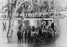
Gympie Road (now Old Gympie Road) passed through Kallangur from Brisbane to Gympie. It was a route travelled by Cobb & Co coaches.
Kallangur grew in the early twentieth century as it was on the main road route to the Redcliffe peninsula before the construction of the Hornibrook Bridge in the 1930s. More recent development has been in response to the general housing demand in the northern growth corridor. The main thoroughfare in Kallangur is route 71, Anzac Avenue.
St Peter's Anglican church, under the authority of Assistant Bishop Wood was closed on 7 March 1993.[4]
An ANZAC memorial gate was erected along with a bronze statue on the corner of Anzac Avenue and Goodfellows Road. The new Memorial Gardens was unveiled in front of the North's Leagues and Services Club in 2005 by the former Minister for Veterans' Affairs De-Anne Kelly.[5]
Demographics
In the 2011 census, Kallangur recorded a population of 18,982 people, 51.1% female and 48.9% male.[6] The median age of the Kallangur population was 33 years, 4 years below the national median of 37. 77.9% of people living in Kallangur were born in Australia. The other top responses for country of birth were New Zealand 5.9%, England 4%, Philippines 0.7%, South Africa 0.7%, Scotland 0.5%. 90.9% of people spoke only English at home; the next most common languages were 0.6% Samoan, 0.4% Hindi, 0.4% Spanish, 0.3% Tagalog, 0.3% German.[6]
Transport
Kallangur railway station was completed in 2016.
Education
- Kallangur State School
- Dakabin State High School
- Undurba State Primary School
- Dakabin State Primary School
- Murrumba Downs State Secondary College
Community groups
The Kallangur branch of the Queensland Country Women's Association meets at 1431 Anzac Avenue.[7]
Kallangur song
Although not an official song, the musical act, Jaded Cadence, has released a song about living in Kallangur,[8] including a verse about the Bruce Highway, Redcliffe, Maroochy, and Cavill Avenue.
Heritage listings
Kallangur has a number of heritage-listed sites, including:
- Anzac Avenue (the road itself)[9]
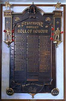
- 1347 Anzac Avenue: Strathpine Honour Board[10]
References
- Australian Bureau of Statistics (27 June 2017). "Kallangur (State Suburb)". 2016 Census QuickStats. Retrieved 29 March 2018.

- "Kallangur (entry 45441)". Queensland Place Names. Queensland Government. Retrieved 30 May 2014.
- "Place names of South-East Queensland - page 33". Archived from the original on 19 August 2008. Retrieved 11 January 2016.
- "Closed Churches". Archived from the original on 3 April 2019. Retrieved 3 April 2019.
- Archived 7 January 2009 at the Wayback Machine
- Australian Bureau of Statistics (31 October 2012). "Kallangur (State Suburb)". 2011 Census QuickStats. Retrieved 26 September 2014.
- "Branch Locations". Queensland Country Women's Association. Archived from the original on 26 December 2018. Retrieved 26 December 2018.
- Archived 18 April 2011 at the Wayback Machine
- "Anzac Memorial Avenue (former) (entry 602693)". Queensland Heritage Register. Queensland Heritage Council. Retrieved 1 August 2014.
- "Strathpine Honour Board (entry 600766)". Queensland Heritage Register. Queensland Heritage Council. Retrieved 11 July 2013.
External links
| Wikimedia Commons has media related to Kallangur, Queensland. |