G55 Erenhot–Guangzhou Expressway
The Erenhot–Guangzhou Expressway (Chinese: 二连浩特—广州高速公路), commonly referred to as the Erguang Expressway (Chinese: 二广高速公路) is an expressway that connects the cities of Erenhot, Inner Mongolia, and Guangzhou, Guangdong. When fully complete, it will be 2,685 km (1,668 mi) in length.
| ||||
|---|---|---|---|---|
| 二连浩特-广州高速公路 | ||||
| Erguang Expressway 二广高速公路 | ||||
 | ||||
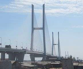 The G55 crossing the Jingzhou Yangtze River Bridge in Hubei province | ||||
| Route information | ||||
| Part of | ||||
| Length | 2,685 km[1] (1,668 mi) Length when complete. | |||
| Major junctions | ||||
| North end | Erenhot, Xilin Gol League, Inner Mongolia (when complete) Baiyinchagan, Chahar Right Back Banner, Ulanqab, Inner Mongolia (current) | |||
| South end | ||||
| Highway system | ||||
National Trunk Highway System
| ||||

Route
Inner Mongolia
Erenhot, the northern terminus of the expressway, is a border town with Mongolia and has a border checkpoint. The expressway is under construction from Erenhot to Baiyinchagan in Ulanqab, and complete from Baiyinchagan to the Shanxi border.
Shanxi
The entire portion of the expressway in Shanxi is complete.
Henan
The entire portion of the expressway in Henan is complete.
Hubei
The entire portion of the expressway in Hubei is complete except for 3 km (1.9 mi) of expressway to the Hunan border.
In 2000, a cache of Warring States period artifacts was discovered in eastern Wulipu's Zuozhong village during the construction of the Xiang(yang)–Jing(zhou) Highway (襄荆高速公路).[2][3]
Hunan
The entire portion of the expressway in Hunan is under construction. This section has been beset by delays and cost overruns.[4]
Guangdong
The expressway is under construction from the Hunan border to Huaiji County, Zhaoqing, and complete from Huaiji County to the southern terminus, Guangzhou.
References
- G55 二广高速. china-highway.com (in Chinese).
- Rui, Jin (瑞金); Su, Dan (苏丹), eds. (November 2012). 沙洋县行政区划图 (in Chinese). Shayang County People's Government. Retrieved 31 March 2018.
{...}G55{...
} - 沙洋文化概况 (in Chinese). Shayang County People's Government. Retrieved 31 March 2018.
{...}2000年,配合襄荆高速公路建设工程,在五里铺镇发掘了左冢,出土了一批战国时期的精美文物;{...}
- Magnier, Mark (2016-07-27). "How a Chinese Highway Became a Boulevard of Broken Dreams". Wall Street Journal. ISSN 0099-9660. Retrieved 2016-07-28.
| Primary | |||||||
|---|---|---|---|---|---|---|---|
| Auxiliary |
| ||||||
Roads and Expressways of Henan | ||||||
|---|---|---|---|---|---|---|
| Urban express roads |
|  | ||||
| Expressways |
| |||||
| National highways | ||||||