Bjerkreim
Bjerkreim is a municipality in Rogaland county, Norway. It is located in the traditional district of Dalane. The administrative centre of the municipality is the village of Vikeså. Other villages in the municipality include Bjerkreim and Øvrebygd.
Bjerkreim kommune | |
|---|---|
 View of the Bjerkreim landscape | |
 Coat of arms  Rogaland within Norway | |
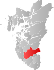 Bjerkreim within Rogaland | |
| Coordinates: 58°39′25″N 06°08′48″E | |
| Country | Norway |
| County | Rogaland |
| District | Dalane |
| Established | 1 Jan 1838 |
| Administrative centre | Vikeså |
| Government | |
| • Mayor (2019) | Kjetil Slettebø (Sp) |
| Area | |
| • Total | 650.56 km2 (251.18 sq mi) |
| • Land | 577.31 km2 (222.90 sq mi) |
| • Water | 73.25 km2 (28.28 sq mi) 11.3% |
| Area rank | 173 in Norway |
| Population (2020) | |
| • Total | 2,787 |
| • Rank | 240 in Norway |
| • Density | 4.8/km2 (12/sq mi) |
| • Change (10 years) | 7.9% |
| Demonym(s) | Bjerkreimsbu[1] |
| Time zone | UTC+01:00 (CET) |
| • Summer (DST) | UTC+02:00 (CEST) |
| ISO 3166 code | NO-1114 |
| Official language form | Nynorsk[2] |
| Website | bjerkreim |
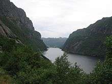
Nature has been generous in giving Bjerkreim many idyllic places, making Bjerkreim a good place to live by living in a countryside environment, but still relatively close to a major city, Stavanger. Bjerkreim has one of the most important salmon rivers in Norway, Bjerkreimselva. The most important livelihoods are agriculture and small-scale industries.
The 651-square-kilometre (251 sq mi) municipality is the 173rd largest by area out of the 356 municipalities in Norway. Bjerkreim is the 240th most populous municipality in Norway with a population of 2,787. The municipality's population density is 4.8 inhabitants per square kilometre (12/sq mi) and its population has increased by 7.9% over the previous 10-year period.[3][4]
General information
The parish of Birkrem was established as a municipality on 1 January 1838 (see formannskapsdistrikt law). On 1 January 1965, there were many municipal changes in Norway due to the work of the Schei Committee. On that date, the Nedre Maudal area of Bjerkreim (population: 40) was transferred to the neighboring municipality of Gjesdal.[5]
Name
The municipality (originally the parish) is named after the old Bjerkreim farm (Old Norse: Bjarkarheimr), since the first Bjerkreim Church was built there. The first element is the genitive case of bjørk which means "birch" and the last element is heimr which means "homestead" or "farm". Before 1889, the name was written "Birkrem".[6]
Coat of arms
The coat of arms was granted on 11 July 1986. The green and white arms are canting, showing a white (or silver) birch branch on a green background. This was chosen since the name of the municipality is derived from the Norwegian word for birch, bjørk.[7]
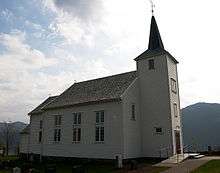
Churches
The Church of Norway has one parish (sokn) within the municipality of Bjerkreim. It is part of the Dalane prosti (deanery) in the Diocese of Stavanger.
| Parish (sokn) | Church name | Location of the church | Year built |
|---|---|---|---|
| Bjerkreim | Bjerkreim Church | Bjerkreim | 1835 |
| Ivesdal Chapel | Øvrebygd | 1876 |
Government
All municipalities in Norway, including Bjerkreim, are responsible for primary education (through 10th grade), outpatient health services, senior citizen services, unemployment and other social services, zoning, economic development, and municipal roads. The municipality has 2 primary schools and 2 kindergartens. The municipality is governed by a municipal council of elected representatives, which in turn elect a mayor.[8] The municipality falls under the Dalane Court and the Gulating Court of Appeal. A notable local politician is Olaf Gjedrem, mayor from 1979 to 1993 and later a member of the national parliament.
Municipal council
The municipal council (Kommunestyre) of Bjerkreim is made up of 17 representatives that are elected to four year terms. The executive committee of the council has 5 members, who also make up the authority's planning and economical committee. The mayor of Bjerkreim leads both the council and the executive committee. Currently, the party breakdown is as follows:
| Party Name (in Nynorsk) | Number of representatives | |
|---|---|---|
| Labour Party (Arbeidarpartiet) | 2 | |
| Progress Party (Framstegspartiet) | 1 | |
| Conservative Party (Høgre) | 4 | |
| Christian Democratic Party (Kristeleg Folkeparti) | 4 | |
| Centre Party (Senterpartiet) | 5 | |
| Liberal Party (Venstre) | 1 | |
| Total number of members: | 17 | |
Geography
Bjerkreim municipality lies at the northern end of the hilly, rugged Dalane district, just south of the very flat Jæren district. There are several large lakes in Bjerkreim including Austrumdalsvatnet, Byrkjelandsvatnet, Hofreistæ, and Ørsdalsvatnet.
Climate
| Climate data for Bjerkreim | |||||||||||||
|---|---|---|---|---|---|---|---|---|---|---|---|---|---|
| Month | Jan | Feb | Mar | Apr | May | Jun | Jul | Aug | Sep | Oct | Nov | Dec | Year |
| Daily mean °C (°F) | −0.5 (31.1) |
−0.6 (30.9) |
1.5 (34.7) |
4.5 (40.1) |
9.5 (49.1) |
13.0 (55.4) |
14.2 (57.6) |
14.3 (57.7) |
11.0 (51.8) |
8.0 (46.4) |
3.5 (38.3) |
0.8 (33.4) |
6.6 (43.9) |
| Average precipitation mm (inches) | 180 (7.1) |
132 (5.2) |
152 (6.0) |
87 (3.4) |
106 (4.2) |
115 (4.5) |
136 (5.4) |
177 (7.0) |
240 (9.4) |
270 (10.6) |
253 (10.0) |
217 (8.5) |
2,065 (81.3) |
| Average precipitation days (≥ 1 mm) | 14.8 | 11.0 | 13.8 | 10.9 | 12.7 | 11.8 | 11.6 | 14.3 | 17.2 | 17.7 | 18.4 | 15.9 | 170.1 |
| Source: Norwegian Meteorological Institute[10] | |||||||||||||
Transportation
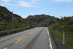
The main means of transportation to Bjerkreim is via the European route E39 highway which passes through the municipality from south to north. The municipality lies in the southwestern part of the country. The distance to the nearest airport, Stavanger airport in Sola, is approximately 40 minutes by car.
References
- "Navn på steder og personer: Innbyggjarnamn" (in Norwegian). Språkrådet.
- "Forskrift om målvedtak i kommunar og fylkeskommunar" (in Norwegian). Lovdata.no.
- Statistisk sentralbyrå (2020). "Table: 06913: Population 1 January and population changes during the calendar year (M)" (in Norwegian).
- Statistisk sentralbyrå (2020). "09280: Area of land and fresh water (km²) (M)" (in Norwegian).
- Jukvam, Dag (1999). "Historisk oversikt over endringer i kommune- og fylkesinndelingen" (PDF) (in Norwegian). Statistisk sentralbyrå.
- Rygh, Oluf (1915). Norske gaardnavne: Stavanger amt (in Norwegian) (10 ed.). Kristiania, Norge: W. C. Fabritius & sønners bogtrikkeri. pp. 47–49.
- "Civic heraldry of Norway - Norske Kommunevåpen". Heraldry of the World. Retrieved 27 June 2016.
- Hansen, Tore, ed. (12 May 2016). "kommunestyre". Store norske leksikon (in Norwegian). Kunnskapsforlaget. Retrieved 6 April 2019.
- "Table: 04813: Members of the local councils, by party/electoral list at the Municipal Council election (M)" (in Norwegian). Statistics Norway.
- "eKlima Web Portal". Norwegian Meteorological Institute. Archived from the original on 14 June 2004.
External links
| Wikimedia Commons has media related to Bjerkreim. |
| Look up Bjerkreim in Wiktionary, the free dictionary. |

- Municipal fact sheet from Statistics Norway (in Norwegian)
- The River Bjerkreim (Bjerkreimselva)
- Visit the South region of Rogaland (Reisemaal Soer Vest)
- Fishing equipment
 |
|  | |||||||||||||||||||||||||
||
| Authority control |
|
|---|