Birampur Upazila
Birampur (Bengali: বিরামপুর) is an Upazila of Dinajpur District[1] in the Division of Rangpur, Bangladesh.
Birampur বিরামপুর | |
|---|---|
Upazila | |
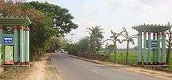 Skyline of Birampur, Bangladesh | |
 Birampur Location in Bangladesh | |
| Coordinates: 25.391479°N 88.992111°E | |
| Country | |
| Division | Rangpur Division |
| District | Dinajpur District |
| Area | |
| • Total | 211.81 km2 (81.78 sq mi) |
| Population (1991) | |
| • Total | 134,778 |
| • Density | 640/km2 (1,600/sq mi) |
| Time zone | UTC+6 (BST) |
| Website | www |
Geography
Birampur has 25770 households and total area 211.81 km2. It is an upazila of Dinajpur.
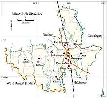
Birampur Upazila is bounded by Fulbari and Nawabganj Upazilas on the north, Nawabganj and Hakimpur Upazilas on the east, Hakimpur Upazila and Hili CD Block in Dakshin Dinajpur district, West Bengal, India, on the south and Kumarganj CD Block in Dakshin Dinajpur district, West Bengal, India, on the west.[2][3][4]
Rivers and Lakes
- Jamuna
- Asholar Beel
- Chengar Beel
- Bogghar Beel
- Katuar Beel
Demographics
As of the 1991 Bangladesh census, Birampur has a population of 134778. Males constitute 51.12% of the population, and females 48.88%. This Upazila's eighteen up population is 68878. Literacy rate and educational institutions Average literacy 46.9%; male 51.7%, female 42%. The Population of Birampur Total 150620; male 77517, female 73103; Muslim 134654, Hindu 8142, Buddhist 3689, Christian 40 and others 4095.[5] The Density of Forestry in Birampur is approximately 18.5%.
Administration
Birampur Upazila is divided into Birampur Municipality and 7 union parishads: Benail, Dior, Jotbani, Katla, Khanpur, Mukundapur, and Pali Prayagpur. The union parishads are subdivided into 171 mauzas and 169 villages.[1]
Md. Khairul Alam Raju is now the Upazila Chairman in the Upazila Chairman election. Election held on 18 March 2019. And so on Md. Liakat Ali Sarker Tutul is working as Mayor of Birampur Pouroshova. Md. Towhidur Rahman is our running U.N.O.
| Serial | Name of Union | Chairman |
|---|---|---|
| 01 | Dior | Abul Hossain |
| 02 | Benail | Nazir Hossen |
| 03 | Jotbani | Eyakub |
| 04 | Katla | Hafizur Rahman |
| 05 | Khanpur | Shahidul Islam |
| 06 | Mukundapur | Abdur Razzaq |
| 07 | Pali Prayagpur | Rahmat Ali |
Economy
The main sources of income Agriculture 68.37%, non-agricultural labourer 2.92%, industry 0.86%, commerce 13.08%, transport and communication 2.64%, service 5.1%, construction 0.67%, religious service 0.16%, rent and remittance 0.17% and others 6.03%. Ownership of agricultural land landowner 57.24%, landless 42.76%; agricultural landowner: urban 44.34% and rural 61.34%. The main crops of Birampur are paddy, wheat, corn, jute, potato, vegetables. Mustard, sugarcane and sesame are near extinction. The main fruits are mango, banana, jackfruit, and blackberry. There are 17 fisheries, dairies and poultries.
Contributions
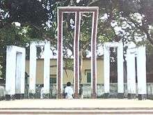
Liberation War 1971
History of the War of Liberation On 20 April 1971, the Pak army killed a few hundred innocent people at Charar Hat of Birampur. Seven Pakistani soldiers and 16 freedom fighters were killed in a direct encounter between the freedom fighters and the Pakistan army at Ketra Hat. On 4 December the general public of the upazila attacked a military vehicle of the Pak army at Beparitola and killed a number of Pak soldiers.
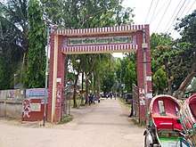
Education
The number of colleges are 5, and respectively textile institute 1, secondary schools 38, primary school 162, madrasa 28. And there is also a digital school here, named Birampur ICT school. And also it is one of the best school of Dinajpur district.
Educational institutions
- Birampur ICT School (2018)
- Birampur Government College (1964)
- Birampur Mahila Degree College (1989)
- Birampur Technical and Management College (2001)
- Adarsha High School and Vocational Institute (1994)
- Ekair Mangalpur High School (1930)
- Birampur Pilot High School (1945)
- Shibpur High School (1951)
- Birampur Government Girl's High School (1971)
- Ideal High School (1998)
- Shiyala Government Primary School
- Bijul Darul Huda Kamil Madrasa (1958)
- Mukundapur Senior Madrasa (1974)
Gallery
See also
- Upazilas of Bangladesh
- Districts of Bangladesh
- Divisions of Bangladesh
References
- Shamsuzzaman (2012). "Birampur Upazila". In Sirajul Islam and Ahmed A. Jamal (ed.). Banglapedia: National Encyclopedia of Bangladesh (Second ed.). Asiatic Society of Bangladesh.
- "Birampur Upazila". Banglapedia. Retrieved 8 December 2018.
- "District Census Handbook 2011 Dakshin Dinajpur" (PDF). Map of Dakshin Dinajpur showing CD Blocks on the fourth page. Directorate of Census Operations. Retrieved 8 December 2018.
- "District Human Development Report". Uttar Dinajpur. Page 14: Map showing locational setting of Uttar Dinajpur district (includes Dakshin Dinajpur district). Department of Planning, Statistics and Programme Implementation, Government of West Bengal. Retrieved 8 December 2018.
- "Population Census Wing, BBS". Archived from the original on 2005-03-27. Retrieved November 10, 2006.
| Upazila/Thana: | ||
|---|---|---|
Capital: Rangpur | ||
| Dinajpur District |
|  |
| Gaibandha District | ||
| Kurigram District | ||
| Lalmonirhat District | ||
| Nilphamari District | ||
| Panchagarh District | ||
| Rangpur District | ||
| Thakurgaon District | ||