Zhangmu
| Zhangmu Town འགྲམ། | |
|---|---|
| Town | |
| 樟木镇 | |
 Zhangmu Town | |
| Coordinates: 27°59′24″N 85°58′48″E / 27.99000°N 85.98000°E | |
| Country |
|
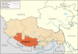
| Province | Tibet Autonomous Region |
| Prefecture | Shigatse Prefecture |
| County | Nyalam County |
| Time zone | UTC+8 (CST) |
| Zhangmu | |||||||||
| Chinese name | |||||||||
|---|---|---|---|---|---|---|---|---|---|
| Chinese | 樟木 | ||||||||
| Literal meaning | neighbor in Tibetan[1] | ||||||||
| |||||||||
| Tibetan name | |||||||||
| Tibetan | འགྲམ། | ||||||||
| |||||||||
| Nepali name | |||||||||
| Nepali | खासा (Khasa) | ||||||||
Zhangmu (also from Tibetan as Dram or Zham, from Nepali as Khasa[2]) is a customs town and port of entry located in Nyalam County on the Nepal-China border, just uphill and across the Bhote Koshi River from the Nepalese town of Kodari. At 2,300 metres (7,500 ft) above sea level, Zhangmu has mild and humid subtropical climate, which is a rarity for Tibet.
History
In ancient times, Kodari, the Nepalese village on the other side, was the starting point of a trans-Himalayan caravan route. Newar traders headed north from Kodari and after crossing Kuti pass turned east to continue their journey across the Tibetan Plateau to Lhasa.
The construction of the 115 kilometres (71 mi) Kathmandu-Kodari Road during the 1963-67 period. It was named China National Highway 318 in China and Araniko Highway in Nepal.
China started building a railway in 2008 connecting Lhasa with Zhangmu on the Nepal-China border. It is an extension of the 1,956 kilometres (1,215 mi) Qinghai-Tibet Railway.[3][4][5]
In 2012, China signed agreement with Nepal to make this one of six ports of entries between Nepal and China.[6]
Zhangmu was evacuated after being damaged by the 2015 earthquakes, which also closed the route between Nepal and China (TAS region).[2] By 2016, it was still a ghost town and trading had not returned to previous level.[2] As of mid-2016, the crossing is still closed with traffic tending to pass through Gyirong Town and (on the Nepalese side) past Rasuwa Fort further west along the border.[7] Chinese and Nepali officials met in December 2016 to discuss potential reopening of Zhangmu port in 2017, which was blocked by progress of road construction.[8]
Transport
Zhangmu is just north of and above the Friendship Bridge border crossing where China National Highway 318 becomes Araniko Highway and immediately passes Kodari village in Sindhupalchok District en route to Kathmandu. Before the earthquake, tourists traveling between Nepal and the Tibet made substantial use of this crossing, and there was also substantial trans-border trade.
Chinese trucks traveling on the Tibet-Nepal Friendship Highway offload goods at Zhangmu and transfer them to Nepalese trucks. Even though the drive between Zhangmu and Kathmandu is only 5[9] hours, the sourcing logistics and bureaucracy of cross-border trade takes around 2 weeks, as such in 2013 it takes each Nepalese truck almost half a month for a round trip.[1]
Gallery
 Zhangmu town
 Zhangmu town
 Zhangmu main street, which is part of the Tibet-Nepal Highway (China National Highway 318).
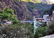 The Tibet-Nepal Bridge below Zhangmu, which is the border crossing between Tibet and Nepal. To the right is the Zhangmu Port Control Point.
 Gateway to China at the Tibet-Nepal Bridge below Zhangmu.
References
- 1 2 "318国道终点站--樟木" [Terminus of G318 Highway — Zhangmu]. Yuanfang De Jia. Season 北纬30°·中国行. Episode 184. 2013-03-19. China Central Television. Retrieved 2017-02-14.
- 1 2 3 Xu, Xiaotong; Liang, Siran (2015-12-18). "Bordering on helplessness". Atavist. Retrieved 2017-02-07.
- ↑ "Kodari Road – Implications for Nepal, China and Inda". Institute of Peace & Conflict Studies. Retrieved 2012-01-02.
- ↑ "Nepal to get China rail link". Asia Times, 15 May 2008. Retrieved 2012-01-02.
- ↑ "New Railroads in Tibet open up economic opportunities". Yo! Learn Chinese! 6 September 2009. Retrieved 2012-04-13.
- ↑ "中华人民共和国政府和尼泊尔政府关于边境口岸及其管理制度的协定" [China-Nepal Agreement on Port of Entry] (in Chinese). Chinese Embassy in Nepal. 2012-01-14. Retrieved 2017-02-10.
- ↑ Rai, Om Astha (17–23 June 2016). "Coming soon the tibet train". Nepali Times. Retrieved 2017-02-13.
- ↑ Jiao, Helen (December 30, 2016). "Zhangmu Port May Reopen in 2017-Tibet Travel News, Tibet Travel Blog". Tibet Travel Agency. Retrieved 2018-01-28.
On December 12, 2016, the representatives of China and Nepal held a meeting on reopening Zhangmu Port. The Nepalese official said that the 15km road from Sino-Nepal Friendship Bridge to Zhangmu Town was under quick development. He hoped that after the completion, the port could reopen.
- ↑ http://www.vehiclerentalnepal.com/trip-packages/kathmandu-kodari-trip.html
External links
| County-level divisions |
|  | ||||
|---|---|---|---|---|---|---|
| Settlements | ||||||
| Landmarks | ||||||
| Geography | ||||||
| Transport |
| |||||