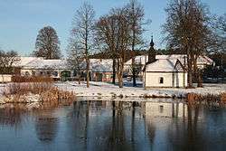
Zahrádka (Třebíč District)
| Zahrádka | |||
|---|---|---|---|
| Municipality | |||
 Center of the village | |||
| |||
 Zahrádka | |||
| Coordinates: 49°14′39″N 16°5′53″E / 49.24417°N 16.09806°ECoordinates: 49°14′39″N 16°5′53″E / 49.24417°N 16.09806°E | |||
| Country |
| ||
| Region | Vysočina | ||
| District | Třebíč | ||
| Area | |||
| • Total | 7.17 km2 (2.77 sq mi) | ||
| Elevation | 415 m (1,362 ft) | ||
| Population (2005) | |||
| • Total | 125 | ||
| • Density | 17/km2 (45/sq mi) | ||
| Postal code | 675 71 | ||
| Website | http://www.obec-zahradka.cz/ | ||
Zahrádka is a village and municipality (obec) in Třebíč District in the Vysočina Region of the Czech Republic.
The municipality covers an area of 7.17 square kilometres (2.77 sq mi), and has a population of 125 (as at 2005).
Zahrádka lies approximately 17 kilometres (11 mi) east of Třebíč, 41 km (25 mi) south-east of Jihlava, and 153 km (95 mi) south-east of Prague.
References
| Wikimedia Commons has media related to Zahrádka (Třebíč District). |
This article is issued from
Wikipedia.
The text is licensed under Creative Commons - Attribution - Sharealike.
Additional terms may apply for the media files.