Láz (Třebíč District)
| Láz | |||
|---|---|---|---|
| Municipality | |||
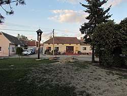 The center of the village | |||
| |||
 Láz | |||
| Coordinates: 49°0′19″N 15°47′28″E / 49.00528°N 15.79111°ECoordinates: 49°0′19″N 15°47′28″E / 49.00528°N 15.79111°E | |||
| Country |
| ||
| Region | Vysočina | ||
| District | Třebíč | ||
| Government | |||
| • Mayor | Miroslav Veith | ||
| Area | |||
| • Total | 4.67 km2 (1.80 sq mi) | ||
| Elevation | 430 m (1,410 ft) | ||
| Population (2016) | |||
| • Total | 277 | ||
| • Density | 59/km2 (150/sq mi) | ||
| Postal code | 675 41 | ||
| Website | http://www.obec-laz.cz | ||


Láz is a village and municipality (obec) in Třebíč District in the Vysočina Region of the Czech Republic. The municipality covers an area of 4.67 square kilometres (1.80 sq mi), and has a population of 274 (as at 3 July 2006). Láz lies approximately 25 kilometres (16 mi) south of Třebíč, 46 km (29 mi) south of Jihlava, and 156 km (97 mi) south-east of Prague.
History
The first written mention of Láz dates back to 1498.
| Year | 1869 | 1880 | 1890 | 1900 | 1910 | 1921 | 1930 | 1950 | 1961 | 1970 | 1980 | 1991 | 2001 |
|---|---|---|---|---|---|---|---|---|---|---|---|---|---|
| Population | 303 | 302 | 311 | 314 | 305 | 314 | 323 | 293 | 319 | 311 | 300 | 283 | 280 |
Landmarks
- A wooden belfry on the town square from the early 19th century
- A memorial plaque in honor of the victims of World War II
- A tribute on the road to Nové Syrovice from the end of the 18th century
Notable people
- Josef Kapinus - educator, writer, painter and sculptor
- Josef Nejedlík - journalist and resistance fighter
- Anton Nejedlik - athlete and weightlifter
References
External links
| Wikimedia Commons has media related to Láz (Třebíč District). |
This article is issued from
Wikipedia.
The text is licensed under Creative Commons - Attribution - Sharealike.
Additional terms may apply for the media files.