Vlčatín
| Vlčatín | |
| municipality | |
 | |
| Country | Czech Republic |
|---|---|
| Region | Vysočina |
| District | Třebíč |
| River | Oslavička |
| Coordinates | 49°18′34″N 15°56′43″E / 49.30944°N 15.94528°ECoordinates: 49°18′34″N 15°56′43″E / 49.30944°N 15.94528°E |
| Highest point | |
| - elevation | 530 m (1,739 ft) |
| Area | 4.77 km2 (1.84 sq mi) |
| Population | 140 (As of 2006) |
| First mentioned | 1296 |
| Mayor | Josef Mezlík |
| Postal code | 675 05 |
  Location in the Czech Republic | |
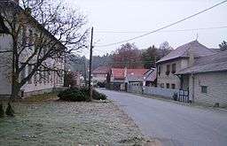
Vlčatín is a Moravian village in the Třebíč district and the Vysočina region. It is located north of Třebíč and 6 km south of Velké Meziříčí. East of the village there are hills named Vlčatínský vrch, Telečkov and Hradisko. There is a railway leading to Náměšť nad Oslavou; the river Oslavička flows through the village.
Vlčatín was first mentioned in 1296, when it was a part of Okarec manor. In 1417 Vlčatín belonged to Vlček z Okárce, in 1447 to Mikuláš Nepr z Vojslavic. The Hradisko hill is a place where there allegedly stood a wooden castle. Only remnants of battlements of a stronghold can still be found there (its name is said to have been Kočičí hrádek). It was burned and destroyed by the soldiers of Jan Žižka z Trocnova.
A chronicle is continually written since 1893. One of the greatest Czech poets of the 20th century, Jan Zahradníček, died in Vlčatín on October 7, 1960.
Landmarks
- A chapel from 1910
- Hradisko with remnants of a stronghold
- A monument of Jan Zahradníček
| Wikimedia Commons has media related to Vlčatín. |