Slavíkovice
| Slavíkovice | |||
|---|---|---|---|
| Municipality | |||
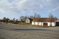 Center of Slavíkovice | |||
| |||
 Slavíkovice | |||
| Coordinates: 49°0′17″N 15°37′9″E / 49.00472°N 15.61917°ECoordinates: 49°0′17″N 15°37′9″E / 49.00472°N 15.61917°E | |||
| Country |
| ||
| Region | Vysočina | ||
| District | Třebíč | ||
| Area | |||
| • Total | 5.51 km2 (2.13 sq mi) | ||
| Elevation | 452 m (1,483 ft) | ||
| Population (2006) | |||
| • Total | 223 | ||
| • Density | 40/km2 (100/sq mi) | ||
| Postal code | 675 31 | ||

Slavíkovice is a village and municipality (obec) in Třebíč District in the Vysočina Region of the Czech Republic.
The municipality covers an area of 5.51 square kilometres (2.13 sq mi), and has a population of 223 (as at 3 July 2006).
Slavíkovice lies approximately 31 kilometres (19 mi) south-west of Třebíč, 44 km (27 mi) south of Jihlava, and 149 km (93 mi) south-east of Prague.
References
This article is issued from
Wikipedia.
The text is licensed under Creative Commons - Attribution - Sharealike.
Additional terms may apply for the media files.