Opatov (Třebíč District)
| Opatov | |
|---|---|
| Městys | |
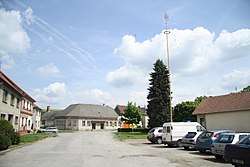 Center of the town | |
 Opatov | |
| Coordinates: 49°13′33″N 15°39′27″E / 49.22583°N 15.65750°ECoordinates: 49°13′33″N 15°39′27″E / 49.22583°N 15.65750°E | |
| Country |
|
| Region | Vysočina |
| District | Třebíč |
| Area | |
| • Total | 19 km2 (7 sq mi) |
| Elevation | 582 m (1,909 ft) |
| Population (2006) | |
| • Total | 768 |
| • Density | 40/km2 (100/sq mi) |
| Postal code | 675 28 |
| Website | http://www.opatov.cz |
Opatov is a market town (městys) in Třebíč District in the Vysočina Region of the Czech Republic.
The town covers an area of 19 square kilometres (7.3 sq mi), and has a population of 768 (as at 3 July 2006).
Opatov lies approximately 17 kilometres (11 mi) west of Třebíč, 20 km (12 mi) south of Jihlava, and 131 km (81 mi) south-east of Prague.
References
| Wikimedia Commons has media related to Opatov (Třebíč District). |
This article is issued from
Wikipedia.
The text is licensed under Creative Commons - Attribution - Sharealike.
Additional terms may apply for the media files.