Wiehle–Reston East station
Wiehle – Reston East | |||||||||||
|---|---|---|---|---|---|---|---|---|---|---|---|
|
| |||||||||||
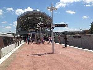 Wiehle–Reston East station on the first day of service | |||||||||||
| Location |
1862 Wiehle Avenue Reston, VA 20190 | ||||||||||
| Coordinates | 38°56′52″N 77°20′25″W / 38.94786°N 77.34041°W | ||||||||||
| Owned by | WMATA | ||||||||||
| Line(s) |
| ||||||||||
| Platforms | 1 island platform | ||||||||||
| Tracks | 2 | ||||||||||
| Connections |
| ||||||||||
| Construction | |||||||||||
| Structure type | Surface | ||||||||||
| Parking | 2,300 spaces | ||||||||||
| Disabled access | Yes | ||||||||||
| Other information | |||||||||||
| Station code | N06 | ||||||||||
| History | |||||||||||
| Opened | July 26, 2014[1] | ||||||||||
| Traffic | |||||||||||
| Passengers (2017) |
7,262 daily[2] | ||||||||||
| Services | |||||||||||
| |||||||||||
Wiehle–Reston East (/ˈwiːli/; preliminary names Wiehle Avenue, Reston–Wiehle Avenue)[3][4] is a Washington Metro station in Fairfax County, Virginia on the Silver Line. It began operation on July 26, 2014,[1] and will be the western terminus of the Silver Line from 2014 until approximately 2020, when Ashburn is anticipated to become the western terminus.[5] Located in Reston, the station is situated alongside Reston Station, a mixed-use urban center.[6]
Station layout
| G | Street Level | Exit/ Entrance |
| M | Mezzanine | One-way faregates, ticket machines, station agent |
| P Platform level |
Eastbound | → (future service: Reston Town Center) |
| Island platform, doors will open on the left | ||
| Eastbound | → | |
.jpg)
The "Wiehle" in the station's name refers to Wiehle Avenue at the eastern end of the station, which itself is named after a small town, Wiehle's Station,[7] built in 1892 that used to be located nearby.[8][9]
The station sits in the median of SR 267, similar to how the Orange Line is located in the median of Interstate 66 from Vienna (the current terminus of the Orange Line). It is about 5.8 miles (9.3 km) from Spring Hill, the next station to the east. The station has approximately 2,300 parking spaces to the north of the road.[10] The main platform has a height of 5 ft (1.5 m) at its east end and 6.5 ft (2.0 m) at its west end.[11]
In order to foster high density development within walking distance of the station, Fairfax County has awarded development rights to an existing 9 acres (3.6 ha) park-and-ride lot on the station site. Reston-based Comstock Partners constructed a 2,300 space below-ground parking structure as well as 1,500,000 square feet (140,000 m2) of commercial and residential space, consisting of more than 500,000 square feet (46,000 m2) of Class A office space, approximately 100,000 square feet (9,300 m2) of restaurants, shops, and service-oriented retailers, a 200-plus room hotel, and approximately 900 luxury residences.[12]
The station is the staging point for the Metropolitan Washington Airports Authority's Silver Line Express Bus, whose 15 minute trips travel between the station and Washington Dulles International Airport every 15 to 20 minutes.[13] The paved Washington & Old Dominion Railroad Trail (W&OD Trail) crosses Wiehle Avenue 0.3 miles (0.5 km) northeast of the station.[14][15]
Station facilities
- 2 station entrances (both sides of SR 267)
- Pedestrian bridge crossing SR 267
- Bus dropoff/pickup (both entrances)
- Kiss & Ride (north side only)
- Secure bike storage room
- Parking for 2,300 cars (north side)
Gallery
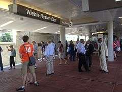 Passengers await the arrival of the second Silver Line train from Wiehle–Reston East on its first day of service
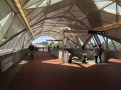 Inside the mezzanine
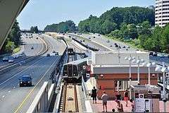 Trains reverse directions on the tail tracks west of the station
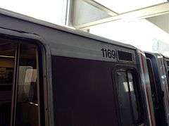 The 1000-series (WMATA's first and original order of rail cars) on Phase 1 of the Silver Line. They have since been retired.
References
| Wikimedia Commons has media related to Wiehle–Reston East (WMATA station). |
- 1 2 "All aboard! Metro's new Silver Line rolls down the tracks for the first time". Washington Post. Retrieved May 28, 2018.
- ↑ "Metrorail Average Weekday Passenger Boardings" (PDF). WMATA. May 2017. Retrieved May 28, 2018.
- ↑ "Board of Supervisors Approves Proposed Silver Line Station Names". April 10, 2012. Retrieved April 11, 2012.
- ↑ Hosh, Kafia (March 29, 2011). "Fairfax OKs names for new Metrorail stations". Washington Post. Retrieved March 29, 2011.
- ↑ Tuss, Adam (April 27, 2015). "Phase Two of Metro's Silver Line Substantially Delayed". NBC Washington. Retrieved March 9, 2018.
- ↑ MacGillis, Alec (February 16, 2006). "County Picks Project for Wiehle Avenue Site; Reston Firm Proposes Substantial Mixed-Use Development on Nine-Acre Park-and-Ride Lot". The Washington Post. Retrieved March 9, 2018.
- ↑ "Max C.J. Wiehle". The Washington Post. August 30, 1956. p. 34.
- ↑ Rosenfeld, Megan (June 13, 1975). "Reston Group Would Revive Extinct Town: Restonites Trying To Revive Wiehle". The Washington Post. p. C1.
- ↑ MacDonald, Gregg (April 4, 2012). "Wiehle's legacy lives on in Reston". The Washington Post.
- ↑ "Park and Ride - Wiehle-Reston East Metro Station". www.fairfaxcounty.gov. Retrieved March 9, 2018.
- ↑ "DCMP Station Heights Actual". WMAA. Retrieved November 10, 2010.
- ↑ MacGillis, Alec (February 16, 2006). "Project Chosen for Site at Planned Metro Stop in Reston". Washington Post. p. LZ03. Retrieved December 19, 2009.
- ↑ "Silver Line Express Bus to Metrorail Station". Dulles International. Metropolitan Washington Airports Authority. Retrieved March 9, 2018.
- ↑ "Station Vicinity Map: Wiehle-Reston East" (PDF). Washington Metropolitan Area Transit Authority. Retrieved September 29, 2017.
- ↑ Merry, Stephanie; Orndorff, Amy; Hahn, Fritz (August 14, 2014). "Riding the rails to trails: Metro offers a car-free path to the great outdoors". Going Out Guide. The Washington Post. Retrieved March 9, 2018.
Once you get to the Wiehle-Reston East stop, take the North exit, which guides you toward Reston Station Boulevard. Walk toward Wiehle Road and take a left, then cross over Sunset Hills Road. Once you see the Pizza Hut, you know you’ve arrived. .... (Note: Wiehle is a busy road and not particularly bike-friendly, but it’s a short, manageable distance from the station to the trail to walk your bike on the sidewalk.)
External links
- WMATA: Wiehle–Reston East Station