Taupo Volcano
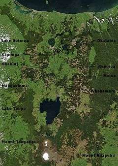
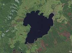
Lake Taupo, in the centre of New Zealand’s North Island, is the caldera of a large rhyolitic supervolcano called the Taupo Volcano. This huge volcano has produced two of the world’s most violent eruptions in geologically recent times.
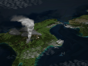
The Taupo Volcano forms part of the Taupo Volcanic Zone, a region of volcanic activity that extends from Ruapehu in the South, through the Taupo and Rotorua regions, to White Island, in the Bay of Plenty.
Taupo began erupting about 300,000 years ago, but the main eruptions that still affect the surrounding landscape are the Oruanui eruption, about 26,500 years ago, which is responsible for the shape of the modern caldera, and the Hatepe eruption, about 1,800 years ago. However, there have been many more eruptions, with major ones every thousand years or so (see timeline of last 10,000 years of eruptions).[1][2][3]
Considering recent history alone, the volcano has been inactive for an unusually long period of time, but considering its long-term activity, it was inactive for much longer between 8100 and 5100 BC (3,000 year inactivity, compared to the current 1,800 years)
Rhyolitic eruptions

The Taupo Volcano erupts rhyolite, a viscous magma, with a high silica content.
If the magma does not contain much gas, rhyolite tends to just form a lava dome. However, when mixed with gas or steam, rhyolitic eruptions can be extremely violent. The magma froths to form pumice and ash, which is thrown out with great force.
If the volcano creates a stable plume, high in the atmosphere, the pumice and ash is blown sideways, and eventually falls to the ground, draping the landscape like snow.
If the material thrown out cools too rapidly, and becomes denser than the air, it cannot rise as high, and suddenly collapses back to the ground, forming a pyroclastic flow, hitting the surface like water from a waterfall, and spreading sideways across the land at enormous speed. When the pumice and ash settles, it is sufficiently hot to stick together as a rock called Ignimbrite. Pyroclastic flows can travel hundreds of kilometres an hour.
Earlier eruptions
Earlier ignimbrite eruptions occurred further north than Taupo. Some of these were enormous, and two eruptions around 1.25 and 1.0 million years ago were big enough to generate an ignimbrite sheet that covered the North Island from Auckland to Napier.
While Taupo has been active for 300,000 years, explosive eruptions became more common 65,000 years ago.
The Oruanui eruption
The Oruanui eruption of the Taupo Volcano was the world's largest known eruption in the past 70,000 years, with a Volcanic Explosivity Index of 8. It occurred around 26,500 years ago and generated approximately 430 km³ of pyroclastic fall deposits, 320 km³ of pyroclastic density current (PDC) deposits (mostly ignimbrite) and 420 km³ of primary intracaldera material, equivalent to 530 km³ of magma.[4][5][6]
Modern Lake Taupo partly fills the caldera generated during this eruption.
Tephra from the eruption covered much of the central North Island with ignimbrite up to 200 metres deep. Most of New Zealand was affected by ash fall, with even an 18 cm ash layer left on the Chatham Islands, 1,000 km away. Later erosion and sedimentation had long-lasting effects on the landscape, and caused the Waikato River to shift from the Hauraki Plains to its current course through the Waikato to the Tasman Sea.
The Taupo eruption
The Taupo eruption (also known as the Hatepe eruption) represents the most recent major eruption of the Taupo Volcano, and occurred about 1,800 years ago. It represents the most violent eruption in the world in the last 5,000 years.[7][8]
Stages of eruption
The eruption went through several stages.
- A minor eruption occurred beneath the ancestral Lake Taupo.
- A dramatic increase in activity produced a high eruption column from a second vent, and pumice was deposited over a wide area.
- Water entered the first vent, and mixed with the magma, producing a white ash-rich pumice fall.
- A new vent formed, and produced a dark ash- and obsidian-rich fall deposit.
- A larger eruption ensued, producing pumice over a huge area, and a small ignimbrite deposit.
- The most destructive part of the eruption then occurred. Part of the vent area collapsed, unleashing about 30 km³ of material, that formed a fast moving (600–900 km/h) pyroclastic flow.
- Rhyolitic lava domes were extruded some years later, forming the Horomatangi reefs and Waitahanui bank.[9]
The main pyroclastic flow devastated the surrounding area, climbing over 1500 metres (5000 ft) to overtop the nearby Kaimanawa Ranges and Mount Tongariro, and covering the land within 80 kilometres (50 mi) with ignimbrite from Rotorua to Waiouru. Only Ruapehu was high enough to divert the flow.
The power of the pyroclastic flow was so strong that in some places it eroded more material off the ground surface than it replaced with ignimbrite. Valleys were filled with ignimbrite, evening out the shape of the land.
All vegetation within the area was flattened. Loose pumice and ash deposits formed lahars down all the main rivers.
The eruption further expanded the lake, which had formed after the much larger Oruanui eruption. The previous outlet was blocked, raising the lake 35 metres above its present level until it broke out in a huge flood, flowing for more than a week at roughly 200 times the Waikato River's current rate.
Dating the Taupo eruption
Many dates have been given for the Taupo eruption. One estimated date is 181 CE from ice cores in Greenland and Antarctica.[10] It is possible that the meteorological phenomena described by Fan Ye in China and by Herodian in Rome[11] were due to this eruption, which would give a date of exactly 186[12] however ash from volcanic activity does not normally cross hemispheres,[13] and recent radiocarbon dating by R. Sparks has put the date at 233 CE +/- 13 (95% confidence).[14]
There was no local population at this time, so the nearest humans would have been those in Australia, more than 2000 km to the west.
References
- ↑ A continent on the move: New Zealand geoscience into the 21st century. Graham, Ian J. et al.; The Geological Society of New Zealand in association with GNS Science, 2008. ISBN 978-1-877480-00-3. page 66, 168.
- ↑ "Taupo the volcano" (a single sheet pamphlet), C.J.N. Wilson and B.F. Houghton, Institute of Geological & Nuclear Sciences, c2004.
- ↑ Information from GNS Science on the Taupo Volcano
- ↑ Wilson, Colin J. N. (2001). "The 26.5 ka Oruanui eruption, New Zealand: an introduction and overview". Journal of Volcanology and Geothermal Research. 112 (1–4): 133–174. Bibcode:2001JVGR..112..133W. doi:10.1016/S0377-0273(01)00239-6.
- ↑ Manville, Vern & Wilson, Colin J. N. (2004). "The 26.5 ka Oruanui eruption, New Zealand: a review of the roles of volcanism and climate in the post-eruptive sedimentary response". New Zealand Journal of Geology & Geophysics. 47 (3): 525–547. doi:10.1080/00288306.2004.9515074. Archived from the original on 2008-09-08.
- ↑ Wilson, Colin J. N.; et al. (2006). "The 26.5 ka Oruanui Eruption, Taupo Volcano, New Zealand: Development, Characteristics and Evacuation of a Large Rhyolitic Magma Body". Journal of Petrology. 47 (1): 35–69. Bibcode:2005JPet...47...35W. doi:10.1093/petrology/egi066.
- ↑ "Taupo the eruption" (a single sheet pamphlet), C.J.N. Wilson and B.F. Houghton, Institute of Geological & Nuclear Sciences, c2004.
- ↑ Wilson, C.J.N. and Walker, G.P.L., 1985. The Taupo eruption, New Zealand I. General aspects. Philosophical Transactions of the Royal Society of London, A314: 199-228.
- ↑ Houghton, B.F. (2007). Field Guide - Taupo Volcanic Zone.
- ↑ Lake Taupo Official Site Archived 2007-03-12 at the Wayback Machine.
- ↑ Herodian of Antioch. "Chapter 14". History of the Roman Empire. Book 1.
Stars remained visible during the day; other stars, extending to an enormous length, seemed to be hanging in the middle of the sky.
- ↑ Barton, John (2001). The First New Zealand Book? — an Eyewitness account of the Taupo eruption of AD 186. New Plymouth: Trustees of the Dalberton Library. ISBN 0-473-08268-3.
- ↑ Iridium: tracking down the extraterrestrial element in sedimentary clays "New Scientist". 1989: 58.
- ↑ Sparks, R.J., Melhuish, W.H., McKee, J.W.A., Ogden, J., Palmer, J.G., 1995. 14C calibration in the Southern Hemisphere and the date of the last Taupo eruption: evidence from tree-ring sequences. Radiocarbon 37, 155–163.
External links
- Lake-floor relief map, from Rowe, Dave; Shankar, Ude; James, Gavin; Waugh, B (July 2002). "Use of GIS to predict effects of water level on the spawning area for smelt, Retropinna retropinna, in Lake Taupo, New Zealand". Fisheries Management and Ecology. John Wiley & Sons Ltd. 9 (4): 205–216. Retrieved 2018-02-28. . Same data exists in Rowe, Dave; James, Gavin; Macaulay, Gavin; Shankar, Ude (October 2002). "High-tech tools for tackling fisheries problems in lakes". Water & Atmosphere. NIWA. 10 (3): 24–25. Archived from the original on 2008-05-02. Retrieved 2008-03-16.
Coordinates: 38°48′20″S 175°54′03″E / 38.80556°S 175.90083°E