York County, Ontario
| York County, Ontario | |
|---|---|
| Dissolved County | |
| Nickname(s): York County | |
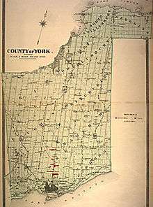 York County c.1880s | |
| Country |
|
| Province |
|
| Incorporated | 1792 created from parts of Home District |
| Dissolved | 1971 - Regional Municipality of York |
| County seat Administrative seat |
York, Upper Canada 1792-1834 Toronto 1834-1953 Newmarket, Ontario 1953-1971 |
| Area | |
| • Total | 2,392.17 km2 (923.62 sq mi) |
| Time zone | UTC-5 (Eastern (EST)) |
York County is a historic county in Upper Canada, Canada West, and the Canadian province of Ontario. It was organized by the Upper Canada administration from the lands of the Toronto Purchase and others.
York County was created on 16 June 1792[1] and was part of the jurisdiction of the Home District of Upper Canada. It originally comprised all of what is now the regional municipalities of York, Peel, and Halton, and the City of Toronto, as well as parts of Durham Regional Municipality and the City of Hamilton. Toronto was the county seat.
In 1816, Wentworth and Halton counties were created (split) from York County. In 1851, Ontario and Peel counties were separated from York.
In 1953, the city of Toronto; the towns of New Toronto, Mimico, Weston, and Leaside; the villages of Long Branch, Swansea, and Forest Hill; and the townships of Etobicoke, York, North York, East York, and Scarborough (everything south of Steeles Avenue) seceded from York County to form Metropolitan Toronto. The county office was moved to Newmarket from Toronto. Toronto's Old City Hall and the Adelaide Street Court House are surviving buildings used by York County during this time period.
In 1971, the remaining portion of York County was replaced by the Regional Municipality of York also known as York Region.
Historic municipalities
- East Gwillimbury - now the Town of East Gwillimbury. Area: 59,064 acres (239 km2). Organized in 1798 and named in honour of Elizabeth Simcoe, wife of the then current lieutenant governor of Upper Canada John Graves Simcoe (a veteran of the war of separation) whose maiden name was Gwillim. Community centres: Sharon, Mount Albert.
- East York - formed in 1924 out of part of York Township. Now in the City of Toronto and named after geographical location relative to York Township. Absorbed town of Leaside in 1967.
- Etobicoke - now in the City of Toronto. Etobicoke Township (area: 27,976 acres (113 km2)) was organized in 1792. It was occupied by Mississauga Indians until it was purchased for £1,700. Etobicoke is a corruption of the Indian Wah-do-be-kaung, "the place where alder grow." Historical community centre was Islington (formerly Mimico). Three Lakeshore communities later developed into separate municipalities: Mimico (1911 Village/1917 Town), New Toronto (1913 Village/1920 Town), Long Branch (1930 Village). With Etobicoke, these left York County in 1953 to join the newly formed urban region Metropolitan Toronto.
- Georgina - merged with North Gwillimbury to form the Town of Georgina. Area: 36,770 acres (149 km2). Named in honour of King George III. The township was opened for settlement in 1815. Historical Community centres were Sutton, Pefferlaw, Udora, Cedarbrae, Vachell and Jackson's Point.
- King - still exists. Area: 88,742 acres (359 km2). Opened in 1798 and was likely named for John King, Under-Secretary of State in the Portland administration. Community centres are King City, Nobleton, Schomberg, Lloydtown, and Kettleby.
- Markham - now the City of Markham. Historically the Township was 67,696 acres (274 km2) and opened in 1792. It was named in honour of the Most Rev. William Markham, Archbishop of York, England, who died in 1807. The Township once included Markham Village, Richmond Hill and Stouffville within its borders. Community centres also included were Unionville, Hagerman's Victoria Square and Mount Joy.
- North Gwillimbury - merged with Georgina to form the Town of Georgina. Named for the geographical location relative to East Gwillimbury. Historical Community centres: Roche's Point, Keswick.
- North York - Formed in 1922 from York Township. now in the City of Toronto and named after its geographical location as the northern part of the Township of York.
- Scarborough - now in the City of Toronto. Historically the township was 40,785 acres (165 km2) and was organized in 1792. It was so named by Lady Simcoe as she thought the clay cliffs at the lakefront resembled similar cliffs in Scarborough in England. Historical community centres were Agincourt, Scarborough Junction, Highland Creek, Wexford and Woburn.
- Vaughan - now the City of Vaughan The historical township was area 67,007 acres (271 km2) and opened in 1792. It was named for Benjamin Vaughan, one of the British commissioners who signed the peace treaty of 1783 with the United States. Other community centres were: Maple, Kleinburg, Thornhill, Concord. A colony of Pennsylvania Quakers were among the earliest settlers.
- Whitchurch - now the Town of Whitchurch-Stouffville. Historic township of Whitchurch was 60,235 acres (244 km2). Opened in 1798, the first settlers were Quakers from Pennsylvania. A number of towns and villages in England are named Whitchurch. It is named for Whitchurch, Herefordshire, birthplace of Elizabeth Simcoe and wife of John Graves Simcoe.
- York - now in the City of Toronto. Historically York, East York and North York Townships. (Areas 6,235, 3,700 and 43,965 acres (178 km2) respectively). York absorbed Weston in 1967. Organized in 1792.
- Toronto - originally the Town of York, it became the City of Toronto in 1834, in 1953 it left York County and joined Metropolitan Toronto. Metro Toronto was later amalgamated into a single-tier municipality known as the City of Toronto, also commonly known as the 'Megacity', in 1998.
Seats
- Toronto (York before 1834) 1792 to 1953
- Newmarket, Ontario 1953 to 1971
County offices
- First York County Courthouse 1800-1824
- Second York County Courthouse 1824-1845
- Adelaide Court House 1852-1900
- Old City Hall, Toronto 1900-1953
- Old Newmarket Town Hall and Courthouse 1953-1970
See also
References
- ↑ "York's first major overhaul since 1850". The Era. 13 May 1970. p. 17. Retrieved 30 April 2015.
- Middleton, Jesse Edgar; Landon, Fred (1927). Province of Ontario — A History 1615 to 1927. Toronto: Dominion Publishing Company.
- Boylen, J.C. (1954). York Township: An Historical Summary 1850-1954. Toronto: Municipal Corporation of the Township of York and the Board of Education of the Township of York.
- Sawdon, Herb H. (1961). The Woodbridge Story. pp. 13–14, .