Westland (municipality), Netherlands
| Westland | |||
|---|---|---|---|
| Municipality | |||
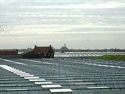 Greenhouses near 's-Gravenzande | |||
| |||
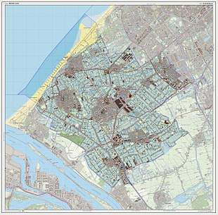
.svg.png) Location in South Holland | |||
| Coordinates: 52°0′N 4°13′E / 52.000°N 4.217°ECoordinates: 52°0′N 4°13′E / 52.000°N 4.217°E | |||
| Country | Netherlands | ||
| Province | South Holland | ||
| Established | 1 January 2004[1] | ||
| Government[2] | |||
| • Body | Municipal council | ||
| • Mayor | Agnes van Ardenne (acting) (CDA) | ||
| Area[3] | |||
| • Total | 90.58 km2 (34.97 sq mi) | ||
| • Land | 79.53 km2 (30.71 sq mi) | ||
| • Water | 11.05 km2 (4.27 sq mi) | ||
| Elevation[4] | 1 m (3 ft) | ||
| Population (August 2017)[5] | |||
| • Total | 106,752 | ||
| • Density | 1,342/km2 (3,480/sq mi) | ||
| Demonym(s) | Westlander | ||
| Time zone | UTC+1 (CET) | ||
| • Summer (DST) | UTC+2 (CEST) | ||
| Postcode | 2290–2295, 2670–2694 | ||
| Area code | 0174 | ||
| Website |
www | ||


Westland (Dutch pronunciation: [ˈʋɛstlɑnt] (![]()
Towns and other settlements: De Lier, 's-Gravenzande, Monster, Naaldwijk, Wateringen, Heenweg, Honselersdijk, Kwintsheul, Maasdijk, Poeldijk, and Ter Heijde.
History
Westland was created on 1 January 2004 by a merger of the municipalities De Lier, 's-Gravenzande, Monster, Naaldwijk and Wateringen.[6] These are also the names of five of the settlements. The others are Heenweg, Honselersdijk, Kwintsheul, Maasdijk, Poeldijk, and Ter Heijde. Westland itself is not the name of a settlement or town, but rather of the region. The City hall is located in the middle of Westland, in Naaldwijk, the second largest settlement in Westland.[7]
The town of Honselersdijk also possesses the largest Flower Auction, FloraHolland, which also has a location in Rijnsburg. This is a very important sector of the Westland economy. Flowers produced in Westland are sold all over the world.
Coastal towns are Ter Heijde (near Monster), Monster itself and 's-Gravenzande. These towns are popular with Germans and people from the Eastern Netherlands. It is not unknown for every holiday campsite to be fully booked with tourists. This is because of their relative proximity to the more popular Scheveningen
Wider area
Westland is part of the Haaglanden conurbation.
In a wider sense, Westland is also the name of the region south-west of the line The Hague - Delft - Rotterdam, approximately consisting of the municipalities Westland and Midden-Delfland, as well as Hoek van Holland (municipality of Rotterdam).
Westland is most known for its horticulture in greenhouses, growing flowers and vegetables.
References
- ↑ "Gemeentelijke indeling op 1 januari 2004" [Municipal divisions on 1 January 2004]. cbs.nl (in Dutch). CBS. Retrieved 28 August 2013.
- ↑ "Burgemeester Agnes van Ardenne" [Mayor Agnes van Ardenne] (in Dutch). Gemeente Westland. Retrieved 28 August 2013.
- ↑ "Kerncijfers wijken en buurten" [Key figures for neighbourhoods]. CBS Statline (in Dutch). CBS. 2 July 2013. Retrieved 12 March 2014.
- ↑ "Postcodetool for 2671GW". Actueel Hoogtebestand Nederland (in Dutch). Het Waterschapshuis. Retrieved 28 August 2013.
- ↑ "Bevolkingsontwikkeling; regio per maand" [Population growth; regions per month]. CBS Statline (in Dutch). CBS. 27 October 2017. Retrieved 27 October 2017.
- ↑ Law on merger, in Dutch, with map
- ↑ http://www.gemeentewestland.nl/smartsite.shtml?id=5902&ch=INT
External links
| Wikimedia Commons has media related to Westland. |
Places adjacent to Westland (municipality), Netherlands | |
|---|---|
