Haaglanden
- Parts of this article have been translated from the Dutch version of this page
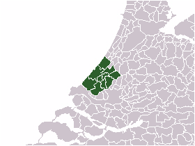
Haaglanden (Dutch pronunciation: [ˈɦaːxlɑndə(n)], literally Haguelands) is the conurbation surrounding The Hague in the Netherlands. The city's position as the country's seat of government makes the region prominent in the Netherlands.[1] Located on the west coast of the province of South Holland, the region has a population of 1,050,543 as of September 2013,[2] and covers an area of 405 km².[3]
Haaglanden is an official term referring to an urban region[4] literally called Haaglanden Urban Region (Stadsgewest Haaglanden). The official website of Haaglanden uses the English translation The Hague Region. Another translation would be the Greater Hague Area. The term is also sometimes used to refer to the conurbation of The Hague in a general, informal sense; "the Hague area" or "the area around The Hague". This area is often treated as a single unit for organisational or statistical purposes.
Haaglanden is part of the larger Rotterdam The Hague Metropolitan Area.
Geography
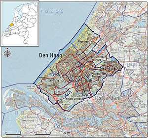
Haaglanden consists of the nine municipalities of The Hague, Zoetermeer, Westland, Delft, Leidschendam-Voorburg, Pijnacker-Nootdorp, Rijswijk, Wassenaar and Midden-Delfland.
| Municipality | Population |
|---|---|
| The Hague | 527,748 |
| Zoetermeer | 124,971 |
| Westland | 106,752 |
| Delft | 101,400 |
| Leidschendam-Voorburg | 74,788 |
| Pijnacker-Nootdorp | 53,420 |
| Rijswijk | 51,742 |
| Wassenaar | 26,101 |
| Midden-Delfland | 19,244 |
The Hague conurbation and the Rotterdam conurbation to the east have grown to the point where they are almost contiguous. They are effectively a single urban area, even though they have separate governments, transport systems, etc. The Hague and Rotterdam share the Rotterdam The Hague Airport and a light rail system called RandstadRail. Consideration is being given to creating an official Metropolitan region Rotterdam The Hague (Metropoolregio Rotterdam Den Haag), which would have a combined population approaching 2.5 million.
Haaglanden is bordered to the north by the Leiden conurbation, which has a population of about a quarter million. These two areas, much like The Hague and Rotterdam, have also grown together to the point where they are virtually contiguous.
Haaglanden is part of the southern wing (the Zuidvleugel) of the Randstad, which also includes the conurbations surrounding Amsterdam and Utrecht. This conurbation is one of the most important economic and densely populated areas in the north-west of Europe.
See also
References
- ↑ This article is primarily a translation of the article on the Dutch Wikipedia, which has no references.
- ↑ Bevolkingsontwikkeling; regio per maand
- ↑ (in Dutch) Kerncijfers. Stadsgewest Haaglanden.
- ↑ "Urban region" referring to the Dutch terms stadsgewest, stadsregio and plusregio, which are more or less used interchangeably.