Villefranche-de-Conflent
| Villefranche-de-Conflent Vilafranca de Conflent | ||
|---|---|---|
| Commune | ||
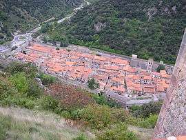 A view of Villefranche from Fort Liberia | ||
| ||
 Villefranche-de-Conflent Location within Occitanie region  Villefranche-de-Conflent | ||
| Coordinates: 42°35′17″N 2°22′07″E / 42.5881°N 2.3686°ECoordinates: 42°35′17″N 2°22′07″E / 42.5881°N 2.3686°E | ||
| Country | France | |
| Region | Occitanie | |
| Department | Pyrénées-Orientales | |
| Arrondissement | Prades | |
| Canton | Les Pyrénées catalanes | |
| Government | ||
| • Mayor (2001–2008) | François Galte | |
| Area1 | 4.46 km2 (1.72 sq mi) | |
| Population (2006)2 | 244 | |
| • Density | 55/km2 (140/sq mi) | |
| Time zone | UTC+1 (CET) | |
| • Summer (DST) | UTC+2 (CEST) | |
| INSEE/Postal code | 66223 /66500 | |
| Elevation |
390–1,395 m (1,280–4,577 ft) (avg. 432 m or 1,417 ft) | |
|
1 French Land Register data, which excludes lakes, ponds, glaciers > 1 km2 (0.386 sq mi or 247 acres) and river estuaries. 2 Population without double counting: residents of multiple communes (e.g., students and military personnel) only counted once. | ||
.svg.png)
Villefranche-de-Conflent (Catalan: Vilafranca de Conflent) is historically a town in the Conflent region of Catalonia, and now a commune in the Pyrénées-Orientales department in southern France.
Geography
Locality
Villefranche-de-Conflent is located in the canton of Les Pyrénées catalanes and in the arrondissement of Prades.
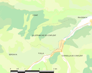
The town's confined site, at about 440 m above sea level, is relatively level ground surrounded by
Transport
- Roads
The N116 from Perpignan on the Mediterranean passes, as a two-lane highway, between the southern town wall and an embankment cut into the high ground to the south;[1] this route continues west into the adjacent Cerdagne region.
- Train
The town's train station starts and ends the route of the scenic Yellow train.
History
The original town dates from 1098, and was fortified because of its strategic position in lands that changed hands between French and Spanish occupation.
- In 1374, Villefranche resisted the siege of Jaume III the son of last king of Majorca.
- In July 1654, the French captured the city after eight days, and the troops of Louis XIV took Puigcerda from the Spaniards.
- The town was part of the program of construction and improvement of outlying French defenses led by through 1707 by Marshal Vauban, and as such is listed as a World Heritage Site.
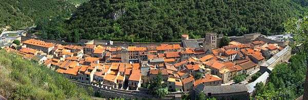
The defensive walls of the town remain.
Population

See also
Notes
References
- Ayats, Alain, "Les fortifications de Vauban", Trabucaire, 2005, ISBN 2-84974-026-8
- INSEE commune file
External links
| Wikimedia Commons has media related to Villefranche-de-Conflent. |