Tautavel
| Tautavel Talteüll | ||
|---|---|---|
| Commune | ||
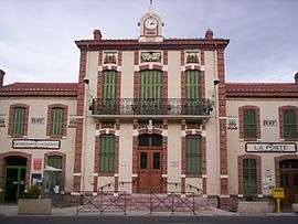 The town hall of Tautavel | ||
| ||
 Tautavel Location within Occitanie region  Tautavel | ||
| Coordinates: 42°48′55″N 2°44′50″E / 42.8153°N 2.7472°ECoordinates: 42°48′55″N 2°44′50″E / 42.8153°N 2.7472°E | ||
| Country | France | |
| Region | Occitanie | |
| Department | Pyrénées-Orientales | |
| Arrondissement | Perpignan | |
| Canton | La Vallée de l'Agly | |
| Intercommunality | Perpignan Méditerranée Métropole | |
| Government | ||
| • Mayor (2001–2008) | Guy Ilary | |
| Area1 | 53.47 km2 (20.64 sq mi) | |
| Population (2007)2 | 910 | |
| • Density | 17/km2 (44/sq mi) | |
| Time zone | UTC+1 (CET) | |
| • Summer (DST) | UTC+2 (CEST) | |
| INSEE/Postal code | 66205 /66720 | |
| Elevation |
65–566 m (213–1,857 ft) (avg. 105 m or 344 ft) | |
|
1 French Land Register data, which excludes lakes, ponds, glaciers > 1 km2 (0.386 sq mi or 247 acres) and river estuaries. 2 Population without double counting: residents of multiple communes (e.g., students and military personnel) only counted once. | ||

Tautavel (Catalan: Talteüll) is a commune in the Pyrénées-Orientales department in southern France.
It is home to The European Centre for Prehistoric Research (CERP). Tautavel Man, an early hominid and some of the oldest human remains in Europe, was found in Caune de l'Arago, a cave in the commune.
Geography
Tautavel is located in the canton of La Vallée de l'Agly and in the arrondissement of Perpignan.
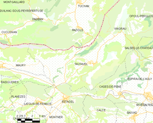
Map of Tautavel and its surrounding communes
Population
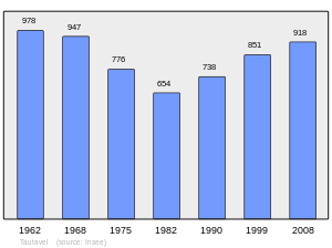
Population 1962-2008
See also
References
External links
| Wikimedia Commons has media related to Tautavel. |
This article is issued from
Wikipedia.
The text is licensed under Creative Commons - Attribution - Sharealike.
Additional terms may apply for the media files.