Clara-Villerach
| Clara-Villerach Clarà i Villerac | |
|---|---|
| Commune | |
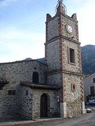 The church of Saint Martin, in Clara | |
 Clara-Villerach Location within Occitanie region  Clara-Villerach | |
| Coordinates: 42°35′10″N 2°26′37″E / 42.5861°N 2.4436°ECoordinates: 42°35′10″N 2°26′37″E / 42.5861°N 2.4436°E | |
| Country | France |
| Region | Occitanie |
| Department | Pyrénées-Orientales |
| Arrondissement | Prades |
| Canton | Les Pyrénées catalanes |
| Intercommunality | Conflent |
| Government | |
| • Mayor (2014–2020) | Robert Laguerre |
| Area1 | 8.70 km2 (3.36 sq mi) |
| Population (2014)2 | 250 |
| • Density | 29/km2 (74/sq mi) |
| Time zone | UTC+1 (CET) |
| • Summer (DST) | UTC+2 (CEST) |
| INSEE/Postal code | 66051 /66500 |
| Elevation |
380–1,880 m (1,250–6,170 ft) (avg. 668 m or 2,192 ft) |
|
1 French Land Register data, which excludes lakes, ponds, glaciers > 1 km2 (0.386 sq mi or 247 acres) and river estuaries. 2 Population without double counting: residents of multiple communes (e.g., students and military personnel) only counted once. | |
Clara-Villerach (Catalan: Clarà i Villerac) is a commune in the Pyrénées-Orientales department in southern France.
Geography
Clara-Villerach is located in the canton of Les Pyrénées catalanes and in the arrondissement of Prades.
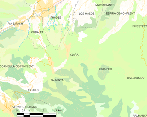
Map of Clara and its surrounding communes
Toponymy
On February 7, 2017 the town's name changed from Clara to Clara-Villerach.[1]
Population
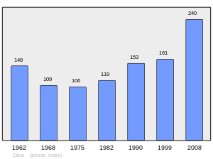
Population 1962-2008
See also
References
- ↑ "Décret n°2017-149 du 7 février 2017 portant changement du nom de communes". www.legifrance.gouv.fr (in French). Legifrance. 7 February 2017. Retrieved 25 March 2017.
External links

- http://histoireduroussillon.free.fr/Villages/Histoire/Claira.php (in French)
This article is issued from
Wikipedia.
The text is licensed under Creative Commons - Attribution - Sharealike.
Additional terms may apply for the media files.