Saint-Pierre-dels-Forcats
| Saint-Pierre-dels-Forcats Sant Pere dels Forcats | ||
|---|---|---|
| Commune | ||
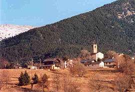 A view of Saint-Pierre-dels-Forcats, from La Cabanasse | ||
| ||
 Saint-Pierre-dels-Forcats Location within Occitanie region  Saint-Pierre-dels-Forcats | ||
| Coordinates: 42°29′44″N 2°07′09″E / 42.4956°N 2.1192°ECoordinates: 42°29′44″N 2°07′09″E / 42.4956°N 2.1192°E | ||
| Country | France | |
| Region | Occitanie | |
| Department | Pyrénées-Orientales | |
| Arrondissement | Prades | |
| Canton | Les Pyrénées catalanes | |
| Intercommunality | Capcir Haut-Conflent | |
| Government | ||
| • Mayor (2001–2008) | Jean-Luc Molinier | |
| Area1 | 12.81 km2 (4.95 sq mi) | |
| Population (1999)2 | 213 | |
| • Density | 17/km2 (43/sq mi) | |
| Time zone | UTC+1 (CET) | |
| • Summer (DST) | UTC+2 (CEST) | |
| INSEE/Postal code | 66188 /66210 | |
| Elevation |
1,320–2,750 m (4,330–9,020 ft) (avg. 1,571 m or 5,154 ft) | |
|
1 French Land Register data, which excludes lakes, ponds, glaciers > 1 km2 (0.386 sq mi or 247 acres) and river estuaries. 2 Population without double counting: residents of multiple communes (e.g., students and military personnel) only counted once. | ||

Saint-Pierre-dels-Forcats (Catalan: Sant Pere del Forcats) is a commune in the Pyrénées-Orientales department in southern France.
Geography
Saint-Pierre-dels-Forcats is located in the canton of Les Pyrénées catalanes and in the arrondissement of Prades.

Map of Saint-Pierre-dels-Forcats and its surrounding communes
Population

Population 1962-2008
See also
References
| Wikimedia Commons has media related to Saint-Pierre-dels-Forcats. |
This article is issued from
Wikipedia.
The text is licensed under Creative Commons - Attribution - Sharealike.
Additional terms may apply for the media files.