Corneilla-de-Conflent
| Corneilla-de-Conflent Cornellà de Conflent | |
|---|---|
| Commune | |
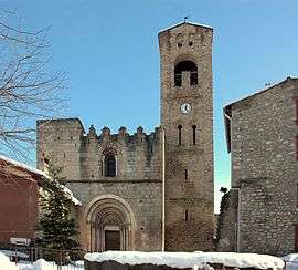 The church of Sainte-Marie, in Corneilla-de-Conflent | |
 Corneilla-de-Conflent Location within Occitanie region  Corneilla-de-Conflent | |
| Coordinates: 42°34′03″N 2°22′53″E / 42.5675°N 2.3814°ECoordinates: 42°34′03″N 2°22′53″E / 42.5675°N 2.3814°E | |
| Country | France |
| Region | Occitanie |
| Department | Pyrénées-Orientales |
| Arrondissement | Prades |
| Canton | Le Canigou |
| Intercommunality | Communauté de communes du Conflent |
| Government | |
| • Mayor (2014–2020) | Patrice Arro |
| Area1 | 11.02 km2 (4.25 sq mi) |
| Population (2014)2 | 468 |
| • Density | 42/km2 (110/sq mi) |
| Time zone | UTC+1 (CET) |
| • Summer (DST) | UTC+2 (CEST) |
| INSEE/Postal code | 66057 /66820 |
| Elevation |
397–823 m (1,302–2,700 ft) (avg. 634 m or 2,080 ft) |
|
1 French Land Register data, which excludes lakes, ponds, glaciers > 1 km2 (0.386 sq mi or 247 acres) and river estuaries. 2 Population without double counting: residents of multiple communes (e.g., students and military personnel) only counted once. | |
Corneilla-de-Conflent (Catalan: Cornellà de Conflent) is a commune in the Pyrénées-Orientales department in southern France.
Geography
Localisation
Corneilla-de-Conflent is located in the canton of Le Canigou and in the arrondissement of Prades.
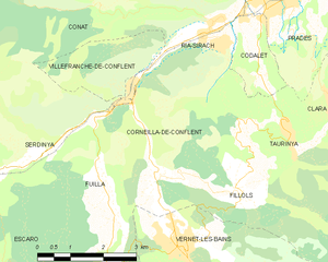
Map of Corneilla-de-Conflent and its surrounding communes
Neighbouring communes
Places adjacent to Corneilla-de-Conflent | |
|---|---|

Population

Population 1962-2008
Sites of interest
It is home to the church of Saint Mary, an 11th-12th century Romanesque building.
See also
References
| Wikimedia Commons has media related to Corneilla-de-Conflent. |
This article is issued from
Wikipedia.
The text is licensed under Creative Commons - Attribution - Sharealike.
Additional terms may apply for the media files.