Reynès
| Reynès Reiners | |
|---|---|
| Commune | |
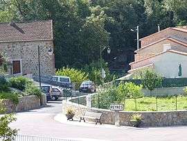 A view within Reynès | |
 Reynès Location within Occitanie region  Reynès | |
| Coordinates: 42°28′34″N 2°42′32″E / 42.4761°N 2.7089°ECoordinates: 42°28′34″N 2°42′32″E / 42.4761°N 2.7089°E | |
| Country | France |
| Region | Occitanie |
| Department | Pyrénées-Orientales |
| Arrondissement | Céret |
| Canton | Le Canigou |
| Intercommunality | Vallespir |
| Government | |
| • Mayor (2008–2014) | Alain Farriol |
| Area1 | 27.56 km2 (10.64 sq mi) |
| Population (1999)2 | 1,203 |
| • Density | 44/km2 (110/sq mi) |
| Time zone | UTC+1 (CET) |
| • Summer (DST) | UTC+2 (CEST) |
| INSEE/Postal code | 66160 /66400 |
| Elevation |
132–1,440 m (433–4,724 ft) (avg. 380 m or 1,250 ft) |
|
1 French Land Register data, which excludes lakes, ponds, glaciers > 1 km2 (0.386 sq mi or 247 acres) and river estuaries. 2 Population without double counting: residents of multiple communes (e.g., students and military personnel) only counted once. | |
Reynès (Catalan: Reiners) is a commune in the Pyrénées-Orientales department in southern France.
Geography
Reynès is in the canton of Le Canigou and in the arrondissement of Céret.

Map of Reynès and its surrounding communes
Population

Population 1962-2008
Talc
Reynès was home to a very productive talc mine which operated from 1876 to 1987. The extracted talc was used in various industries: soap making in Marseilles, porcelain making in Limoges and leather curing. In 1929 the mine installed an aerial wire system to facilitate the transportation of wagons down into the deep valley. In 1930, 440 tons of talc were extracted from the mine.
See also
References
| Wikimedia Commons has media related to Reynès. |
This article is issued from
Wikipedia.
The text is licensed under Creative Commons - Attribution - Sharealike.
Additional terms may apply for the media files.