Brouilla
| Brouilla Santa Maria de Brullà | |
|---|---|
| Commune | |
 The church of Sainte-Marie, in Brouilla | |
 Brouilla Location within Occitanie region  Brouilla | |
| Coordinates: 42°34′03″N 2°54′16″E / 42.5675°N 2.9044°ECoordinates: 42°34′03″N 2°54′16″E / 42.5675°N 2.9044°E | |
| Country | France |
| Region | Occitanie |
| Department | Pyrénées-Orientales |
| Arrondissement | Céret |
| Canton | Les Aspres |
| Intercommunality | Aspres |
| Government | |
| • Mayor (2014–2020) | Pierre Taurinya |
| Area1 | 7.83 km2 (3.02 sq mi) |
| Population (2014)2 | 1,254 |
| • Density | 160/km2 (410/sq mi) |
| Time zone | UTC+1 (CET) |
| • Summer (DST) | UTC+2 (CEST) |
| INSEE/Postal code | 66026 /66620 |
| Elevation |
27–108 m (89–354 ft) (avg. 46 m or 151 ft) |
|
1 French Land Register data, which excludes lakes, ponds, glaciers > 1 km2 (0.386 sq mi or 247 acres) and river estuaries. 2 Population without double counting: residents of multiple communes (e.g., students and military personnel) only counted once. | |
Brouilla (Catalan: Brullà) is a commune in the Pyrénées-Orientales department in southern France.
Geography
Localisation
Brouilla is located in the canton of Les Aspres and in the arrondissement of Perpignan.
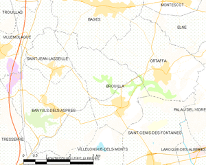
Map of Brouilla and its surrounding communes
Neighbouring communes
Places adjacent to Brouilla | |
|---|---|

Government and politics
Mayors
| Mayor | Term start | Term end |
|---|---|---|
| François Nègre | 1959 | 1971 |
| Michel Capdet | 1971 | 1991 |
| Roger Parada | 1991 | 1995 |
| Pierre Taurinya | 1995 |
Population
| Historical population | ||
|---|---|---|
| Year | Pop. | ±% |
| 1962 | 530 | — |
| 1968 | 537 | +1.3% |
| 1975 | 564 | +5.0% |
| 1982 | 616 | +9.2% |
| 1990 | 565 | −8.3% |
| 1999 | 630 | +11.5% |
| 2007 | 990 | +57.1% |
| 2009 | 1,037 | +4.7% |
See also
References
| Wikimedia Commons has media related to Brouilla. |
This article is issued from
Wikipedia.
The text is licensed under Creative Commons - Attribution - Sharealike.
Additional terms may apply for the media files.