Fenouillet, Pyrénées-Orientales
| Fenouillet Fenolhet (oc) - Fenollet (cat) | ||
|---|---|---|
| Commune | ||
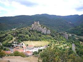 Fenouillet and the Castel Sabarda | ||
| ||
 Fenouillet Location within Occitanie region  Fenouillet | ||
| Coordinates: 42°47′36″N 2°22′52″E / 42.7933°N 2.3811°ECoordinates: 42°47′36″N 2°22′52″E / 42.7933°N 2.3811°E | ||
| Country | France | |
| Region | Occitanie | |
| Department | Pyrénées-Orientales | |
| Arrondissement | Prades | |
| Canton | La Vallée de l'Agly | |
| Intercommunality | Agly Fenouillèdes | |
| Government | ||
| • Mayor (2001–2008) | Jean-Louis Raynaud | |
| Area1 | 18.76 km2 (7.24 sq mi) | |
| Population (1999)2 | 66 | |
| • Density | 3.5/km2 (9.1/sq mi) | |
| Time zone | UTC+1 (CET) | |
| • Summer (DST) | UTC+2 (CEST) | |
| INSEE/Postal code | 66077 /66220 | |
| Elevation |
373–1,208 m (1,224–3,963 ft) (avg. 444 m or 1,457 ft) | |
|
1 French Land Register data, which excludes lakes, ponds, glaciers > 1 km2 (0.386 sq mi or 247 acres) and river estuaries. 2 Population without double counting: residents of multiple communes (e.g., students and military personnel) only counted once. | ||

Fenouillet is a commune in the Pyrénées-Orientales department in southern France.
Geography
Fenouillet is located in the canton of La Vallée de l'Agly and in the arrondissement of Perpignan.
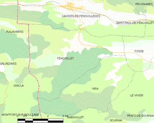
Map of Fenouillet and its surrounding communes
Population
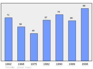
Population 1962-2008
Sites of interest
- The Château Vicomtal Saint-Pierre de Fenouillet is a ruined 11th century castle.
See also
References
| Wikimedia Commons has media related to Fenouillet (Pyrénées-Orientales). |
This article is issued from
Wikipedia.
The text is licensed under Creative Commons - Attribution - Sharealike.
Additional terms may apply for the media files.