Santa Lucia Range
| Santa Lucia Range | |
|---|---|
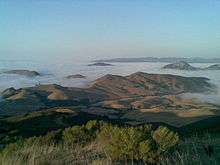
 November 2005 view from summit of Cone Peak, the highest coastal mountain in the lower 48 US states. | |
| Highest point | |
| Peak | Junipero Serra Peak |
| Elevation | 5,857 ft (1,785 m) |
| Geography | |
 location of Santa Lucia Range in California [1] | |
| Country | United States |
| State | California |
| Region |
Monterey County San Luis Obispo County |
| Range coordinates | 36°3′3.861″N 121°28′8.769″W / 36.05107250°N 121.46910250°WCoordinates: 36°3′3.861″N 121°28′8.769″W / 36.05107250°N 121.46910250°W |
| Topo map | USGS Cone Peak |

.jpg)
The Santa Lucia Mountains or Santa Lucia Range is a rugged mountain range in coastal central California, running from Monterey County southeast for 105 miles (169 km) into central San Luis Obispo County. It includes Cone Peak, which at 5,158 feet (1,572 m) tall and three miles (5 km) from the coast, is the highest peak in proximity to the ocean in the lower 48 United States.[2] The range forms the eastern boundary of the Big Sur region, and was a barrier to exploring the coast of California for early Spanish explorers.
Geography
The Santa Lucia Mountains are part of the Outer South California Coast Ranges, in the Pacific Coast Ranges System. Its northern section runs parallel to the southern section of the Diablo Range, part of the Inner South Coast Ranges, which lies to the east across the Salinas Valley. The range's highest summit is Junipero Serra Peak, 1,784 metres (5,853 ft) in Monterey County and the Los Padres National Forest.[3]
Major peaks
- Junipero Serra Peak, 5,857 feet (1,785 m).[4]
- Cone Peak, 5,158 feet (1,572 m).[5] Cone Peak features the steepest coastal elevation in the lower 48 United States,[2] rising nearly a mile (1,609 m) above sea level, only three miles (5 km) from the Pacific Ocean.
- Ventana Double Cone, 4,856 feet (1,480 m).[6]
- Mount Carmel, 4,420 feet (1,347 m).[7]
History and toponymy
The first European to document the Santa Lucias was Juan Rodríguez Cabrillo in 1542 while sailing northward along the coast on a Spanish naval expedition. Cabrillo originally named the southern portion of the range the Sierras de San Martín, as he was passing the area on 11 November, the feast day for Saint Martin. He named the northern part Sierras Nevadas because there was snow on it.[8]
The present name for the range was documented in 1602 by Sebastián Vizcaíno, who had been tasked by the Spanish to complete a detailed chart of the coast. Passing by the range on 14 December, he named the range Sierra de Santa Lucia in honor of Saint Lucy of Syracuse.[8]
The first European land exploration of Alta California, the Spanish Portolà expedition, camped on the coast near Ragged Point in present-day San Luis Obispo County on September 13, 1769. The expedition was forced to bypass the inaccessible coast and travel inland through the San Antonio Valley. The rough trail required much improvement by the scouts, and it was September 24 before the party emerged from the mountains at the San Antonio River near today's settlement of Jolon.[9] They traveled north through the Salinas Valley before arriving at Monterey Bay, where they founded Monterey and named it their capital.[10].
Natural history
Climate
Like other Pacific Coast Ranges, the mountains' close proximity to the Pacific Ocean cause moisture to be deposited on the west-facing slopes, creating a suitable environment for conifers. This creates a rain shadow over Salinas Valley to the east, which is considerably drier. The higher peaks receive some snowfall during the winter.
The climate is classified as dry summer subtropical, or Mediterranean. Rainfall varies from 16 to 60 inches (41 to 152 cm) throughout the range. Most of the precipitation falls during the winter on the higher mountains in the north. During the summer, fog and low clouds are frequent along the coast up to an elevation of 2-3,000 feet. Surface runoff from rainfall is rapid, and many streams dry up entirely in the summer, except for some perennial streams in the wetter areas in the north.[11]
Geology

The rock of the Santa Lucias is dominated by granitic basement of the Salinian Block, between the San Andreas Fault and Sur-Nacimiento Fault. The core of the Salinian block formed as part of the same batholith which forms the core of the Sierra Nevada Mountains and the Peninsular Ranges of Baja California. It was separated from the North American Plate and transported north by the action of the San Andreas Fault from an original position. It is predominantly Mesozoic granitic and pre-Cretaceous metamorphic rocks. There is some Cretaceous sedimentary rock of the Great Valley Sequence, considerable Miocene marine sediments, and some other Cenozoic sediments. Units west of the Sur-Nacimiento Fault are dominated by rocks of the Franciscan Assemblage.
Flora
The western slopes of the range facing the Pacific Ocean are moist with healthy forest growth; including coast redwood, Douglas fir, ponderosa pine, Pacific madrone and the local endemics Santa Lucia fir (Abies bracteata) and Gowen cypress (Cupressus goveniana var. goveniana). The east side is drier, with chaparral and open woods of pine (including Coulter pine and gray pine) and oak woodlands of several Quercus species.
These mountains are home to the southernmost native stands of coast redwood trees, since the climate gets drier towards the south. This range is the only known habitat of the Vortriede's spineflower.
Transportation
California State Route 1 runs along the Big Sur coast on the coastal slopes of the range, while U.S. Route 101 lies in the Salinas Valley to the East. The only road across the Santa Lucia Range is Nacimiento-Fergusson Road, from Lucia to Jolon.[12]
Contemporary history
Pacific Southwest Airlines Flight 1771 crashed in the mountains near Cayucos on December 7, 1987 after a gunman killed both pilots, causing the aircraft to crash. A total of 43 people were killed with no survivors.
Wine
The Santa Lucia Highlands AVA, a producer of California wine, is located in the region.
See also
References
- ↑ "Santa Lucia Range". Geographic Names Information System. United States Geological Survey. Retrieved 2009-05-03.
- 1 2 McKinney, John (1996), Walking California's Central Coast: A Day Hiker's Guide, HarperSanFrancisco, p. 128, ISBN 9780062586360,
Steepest coastal slope in the continental United States
. - ↑ "Junipero Serra Peak". Geographic Names Information System. United States Geological Survey. Retrieved 2009-05-03.
- ↑ "Santa Lucia". NGS data sheet. U.S. National Geodetic Survey. Retrieved 2014-03-04.
- ↑ "Cone Peak, California". Peakbagger.com. Retrieved 2014-03-04.
- ↑ "Ventana Double Cone, California". Peakbagger.com. Retrieved 2014-03-04.
- ↑ "Mount Carmel, California". Peakbagger.com. Retrieved 2014-03-04.
- 1 2 Gudde, Erwin G. (1949). California Place Names. Berkeley, California: University of California Press. p. 316. ASIN B000FMOPP4.
- ↑ Bolton, Herbert E. (1927). Fray Juan Crespi: Missionary Explorer on the Pacific Coast, 1769-1774. HathiTrust Digital Library. pp. 190–194. Retrieved September 7, 2016.
- ↑ Bolton, Herbert E. (1927). Fray Juan Crespi: Missionary Explorer on the Pacific Coast, 1769–1774. HathiTrust Digital Library. (This book also contains a translation of Crespi's diary from the Fages 1772 expedition.)
- ↑ "Santa Lucia Range ecological subregion information". U.S Forest Service. Archived from the original on 2005-03-15. Retrieved 2014-02-22.
- ↑ Bisbort, Alan; Puterbaugh, Parke (2009), Moon California Beaches: The Best Places to Swim, Play, Eat, and Stay (4th ed.), Avalon Travel, p. 305, ISBN 978-1-56691-614-1 ; Schulte-Peevers, Andrea (2003), California (3rd ed.), Lonely Planet, p. 665, ISBN 978-1-86450-331-9 .
External links
| Wikimedia Commons has media related to Santa Lucia Mountains (California). |
- Los Padres National Forest — official Monterey Ranger District website — recreation maps, locations, and info.
- Ventana Wilderness Alliance — dedicated to the protection, preservation, enhancement, and restoration of the wilderness qualities and biodiversity of the public lands within California's northern Santa Lucia Mountains.