Veenendaal
| Veenendaal | |||
|---|---|---|---|
| Municipality | |||
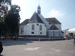 Church in Veenendaal | |||
| |||
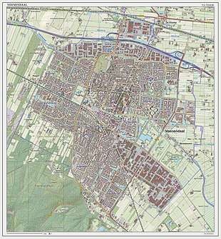
.svg.png) Location in Utrecht | |||
| Coordinates: 52°1′N 5°33′E / 52.017°N 5.550°ECoordinates: 52°1′N 5°33′E / 52.017°N 5.550°E | |||
| Country | Netherlands | ||
| Province | Utrecht | ||
| Government[1] | |||
| • Body | Municipal council | ||
| • Mayor | Piet Zoon (acting) (VVD) | ||
| Area[2] | |||
| • Total | 19.72 km2 (7.61 sq mi) | ||
| • Land | 19.51 km2 (7.53 sq mi) | ||
| • Water | 0.21 km2 (0.08 sq mi) | ||
| Elevation[3] | 6 m (20 ft) | ||
| Population (August 2017)[4] | |||
| • Total | 64,629 | ||
| • Density | 3,313/km2 (8,580/sq mi) | ||
| Demonym(s) | Veenendaler | ||
| Time zone | UTC+1 (CET) | ||
| • Summer (DST) | UTC+2 (CEST) | ||
| Postcode | 3900–3907 | ||
| Area code | 0318 | ||
| Website |
www | ||

Veenendaal (Dutch pronunciation: [ˈveːnə(n)ˌdaːl]) is a municipality and a town in central Netherlands, it is part of the province of Utrecht. Veenendaal is the only population centre within its administrative borders. The municipality had a population of 64,629 in 2017 and covers an area of 19.72 km2 (7.61 sq mi).
History
The original village was founded in the 16th century as a peat colony from which it got its name. Veen is the Dutch word for peat and daal for valley, so literally the name means "peat valley". In 1855 Veenendaal was hit by a flood. After that wool and tobacco industry became Veenendaal's largest source of income, roughly until World War II. Until just after World War II, Veenendaal remained a small community with only a few thousand residents. In the last fifty years, the town grew rapidly to the city with 63,000+ inhabitants of today.
Until the second half of the 20th century, Veenendaal was divided into two parts, a 'Gelders' and an 'Utrechts' part ('Gelders' comes from Gelderland and 'Utrechts' from Utrecht, both Dutch provinces). This is because in the first few centuries of the town's existence it was too small to be its own municipality. The southern half eventually became independent from Rhenen and Renswoude in 1795. The northern half separated from Ede in 1960.
In 1997 it was elected the greenest city in Europe and in 2004 of the Netherlands.
Like most Dutch cities, Veenendaal is well adapted to the high number of cyclists. A large network of bike paths make it convenient to cycle to various destinations and within the town, the bike is the most popular mean of transportation. In 2000, Veenendaal was chosen as Fietsstad 2000 — the top Bike City of the Netherlands for 2000.
Religion
The city is known for being one of the bigger cities within the Dutch Bible Belt (together with Ede and Kampen), as it is inhabited by a considerable number (though not a majority) of conservative Protestants.
Gallery
 Veenendaal, reformed church
 Veenendaal, tower in the street
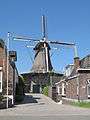 Veenendaal, windmill: stellingmolen de Vriendschap
 Veenendaal, towngate: de Bernard van Kreelpoort
Notable residents
- Rob Barel (1957) - athlete, triathlon
- Stef Bos (1961) - Dutch singer
- Yuri Landman (1973) - Experimental musical instrument builder
- Frits Wester (1962) - Dutch TV political analyst
- Daryl van Wouw (1977) - Fashion designer
- Joram Metekohy (Wildstylez) - Hardstyle DJ
- Willem Rebergen (Headhunterz) - Hardstyle DJ
- Nicky Romero - DJ
- F.R. - Graffiti artist
- DJ Jean - (1968) - DJ
- Kees Stip (1913-2001) Dutch epigram poet[5]
Tirsa Andes Pagano Fitness expert
References
- ↑ "Burgemeester mr. Wouter Kolff" (in Dutch). Gemeente Veenendaal. Retrieved 10 April 2014.
- ↑ "Kerncijfers wijken en buurten" [Key figures for neighbourhoods]. CBS Statline (in Dutch). CBS. 2 July 2013. Retrieved 12 March 2014.
- ↑ "Postcodetool for 3901GA". Actueel Hoogtebestand Nederland (in Dutch). Het Waterschapshuis. Retrieved 10 April 2014.
- ↑ "Bevolkingsontwikkeling; regio per maand" [Population growth; regions per month]. CBS Statline (in Dutch). CBS. 27 October 2017. Retrieved 27 October 2017.
- ↑ "Kees Stip". dbnl.org (in Dutch). DBNL (Digital Library for Dutch Literature). Retrieved 5 September 2015.
External links
| Wikimedia Commons has media related to Veenendaal. |
Places adjacent to Veenendaal | ||||||||||
|---|---|---|---|---|---|---|---|---|---|---|
| ||||||||||
Municipalities of Utrecht | ||
|---|---|---|
 | ||
| ||