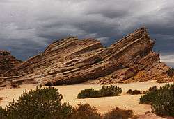
Vasquez Rocks
|
Vasquez Rocks | |
 Vasquez Rocks | |
   | |
| Location | Escondido Canyon Rd., Agua Dulce, California |
|---|---|
| Nearest city | Agua Dulce, California |
| NRHP reference # | 72000228 |
| Added to NRHP | June 22, 1972 |
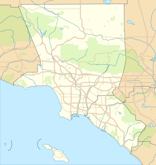
Vasquez Rocks Natural Area Park is a 932-acre (377-hectare) park located in the Sierra Pelona Mountains in northern Los Angeles County, California. It is located in the town of Agua Dulce, between the suburbs of Santa Clarita and Palmdale. The area is also visible from the Antelope Valley Freeway (State Route 14).
History
These rock formations were formed by rapid erosion during uplift about 25 million years ago, and then later exposed by uplift activity along the San Andreas Fault.[1][2]
The Tataviam people were living here when the Spanish arrived. Their language was most likely a Takic Uto-Aztecan language. They lived in grass huts within villages. With the coming of the Spanish missions, some members of this people were forced to work there. They eventually began speaking Spanish and inter-marrying with other tribes. The last of the Tataviam people died in 1916.[3]
In 1874, Tiburcio Vásquez, one of California's most notorious bandits, used these rocks to elude capture by law enforcement. His name has since been associated with this geologic feature.[4]
The land and rock formations were acquired gradually by Los Angeles County, beginning with a donation of 40 acres in 1971, with more parcels being added through 2001.[5] The Pacific Crest Trail crosses through the park.
Vasquez Rocks was added to the National Register of Historic Places (site #72000228) in 1972 because of its significance as a prehistoric site for the Shoshone and Tataviam peoples.[6]
Formation
Literature reviews have dated the earliest sedimentation of the Vasquez Formation occurring between the later portion of the Oligocene Epoch to the lower Miocene Epoch, each respectively 33.9-23 million years ago and 23.03-5.3 million years ago.[7][8][9]
The Vasquez Formation is located just east of the city of Santa Clarita, Los Angeles County, California. It resides within the Soledad Basin, an orthogonal rift between the Sierra Pelona Mountains to the northwest and the San Gabriel Mountains to the east, which are both within the province of the Transverse Mountain Range of Southern California[9]. The San Andreas Fault runs parallel behind the Sierra Pelona Mountains and separates the formation from the North American Plate.
The Vasquez Formation consists of alluvial sediments eroded from the Sierra Pelona and San Gabriel Mountains and were deposited in alluvial fans on both sides of the Soledad Basin.[10] Erosion of the sediment included processes like rain, floods, wind, and earthquakes.[10] Over the course of millions of years, the sediment was laid down under alternating lacustrine and fluviatile conditions.[11] Once laid flat across the basin floor, immense pressure converted the layers into sandstone, which became covered with younger sediment deposits. The sediment beds reside in a sharply-folded syncline.[11]
Due to its proximity to the San Andreas Fault, tectonic activity has been an important factor in the reshaping, uplift, and exposure of the buried sandstone. The Elkhorn Fault, an offshoot of the San Andreas Fault, runs through the Vasquez Rocks Natural Area Park[10]. Other faults, such as the Pelona, Vasquez Canyon, Soledad, and San Gabriel Faults, are all within proximity of the formation. The most exposed portion of the Vasquez Formation is the oldest tertiary formation within the east portion of the Ventura Basin[11].
The Vasquez Rocks consist mainly of coarse-grained conglomerate and breccia sediments, which were deposited adjacent to active faults during rapid uplift and consequent erosion of the San Gabriel Mountains. Approximately 25 million years ago (late Oligocene time), the collision of the North American and Pacific tectonic plates uplifted the area along the Elkhorn Fault.[12] Energetic erosion of the highland along with uplift and volcanism caused debris flow sediments to be distributed in alluvial fans into a rapidly subsiding rift known as the Soledad Basin.[9] These sediments were buried and lithified through the Miocene and became exposed more recently via activity along the San Andreas fault system.[13] The strata are now highly tilted and disconnected from their source area. The strata was deformed and offset by the later fault activity. The distinctive hogback ridges of steeply inclined strata serve to graphically demonstrate the significant fault activity in the area. It is possible to see the extreme variance in grain size between layers of sediment where the strata is exposed. These sedimentary rocks, named the Mint Canyon Formation, were laid down about 8-15 million years ago. In the upper layers, many animal fossils have been found, including camels, horses and rodents.[14]
Role in entertainment
In 1935, Universal Pictures assigned Stanley Bergerman as executive producer on the film Werewolf of London. Bergerman suggested Vasquez Rocks as the filming location used to portray Tibet.[15] Since then, its location inside the Thirty-mile studio zone has ensured Vasquez Rocks'repeated usage in motion pictures, television series, and advertising.
The site once held the exterior façade of the fort featured in the 1950s television series Tales of the 77th Bengal Lancers. Even after the series ended, the façade could still be seen there until around 1964-65. It was finally torn down because the rickety wooden stairs leading up to a rampart posed a danger to those that attempted to climb them.
Vazquez Rocks is prominently featured in a 1963 episode of Outer Limits called "The Zanti Misfits". The rocks are also in several television westerns, including the 1959 "Whipsaw" episode of Tombstone Territory, the Bonanza episode "Between Heaven and Earth", The Wild Wild West episode "The Night of the Cadre", and the opening credits of the TV Western Laramie as Slim Sherman and Jess Harper come riding down, each from one side. The rock formations are also seen in the Michael Jackson music video "Black or White" when he dances with Plains Native Americans, and in an original series Star Trek episode "Arena", where Captain Kirk rolls a boulder onto a reptiloid alien called a Gorn.
The prominent rock formation has been nicknamed "Kirk's Rock" due to being featured in several Star Trek episodes, each time representing a different planet.[16]
Vazquez Rocks is also present on the cover of Village People's 1978 album Cruisin', which includes the group's all-times greatest smash hit "Y.M.C.A.".
The use of the rock as a place to struggle with an enemy was echoed in the film Bill & Ted's Bogus Journey twice, once replaying the Gorn-themed Star Trek episode on the TV, and again when the title characters are murdered by their doubles at the same location. A scene at a diner in Jay and Silent Bob Strike Back was filmed in front of the rocks, and in homage to the Star Trek episode, the diner is called The Arena Diner.[17]
Feature films shot at Vasquez Rocks include Dante's Peak, Hot Shots! Part Deux, Rustlers' Rhapsody, The Flintstones, Blazing Saddles, Star Trek V: The Final Frontier, Free Enterprise, and Hail, Caesar!. Television shows include The Fugitive, F Troop, The A-Team, and MacGyver. Commercials for Taco Bell, Bank of America, Pacific Bell, Pepsi, and Nike have also been filmed at the rocks. In addition to Michael Jackson, Greta Van Fleet, 311, Eddie Money, Sammy Kershaw, and Lee Tae-min, member of the Korean Boy Band Shinee, also shot music videos here.[18]
Vasquez Rocks was also used prominently throughout all three seasons of the science-fiction television series Roswell as an important location for the main characters and their story. The area is also featured as the location of the Command Center/Power Chamber for Mighty Morphin Power Rangers throughout Power Rangers Turbo. In a season-five episode of Friends - "The One with Joey's Big Break" - Joey lands the lead role in a movie being filmed at the Vasquez Rocks (though the peaks are not seen on camera). It is also featured in the movie Paul, and in the 2009 "South by Southwest" episode of NCIS. The final episode of New Girl season 1 is primarily set here with the Rocks prominent in the background.
In the Big Bang Theory episode "The Bakersfield Expedition", which aired in 2013, the four male protagonists appear to stop here, thanks to green screen, on their road trip to San Diego Comic-Con in Bakersfield, CA. Since they have Star Trek: The Next Generation-themed costumes for the costume contest at ComicCon, they decide to have a brief photoshoot at the Star Trek filming site. Their stop goes horribly wrong when someone steals their car as they are taking pictures. In the episode "The Adhesive Duck Deficiency", the characters attempt to observe a meteor shower from "34.48° N, 118.31°W", the map coordinates of the Vasquez Rocks formation, to make it appear as if they were there.
The same formations can clearly be seen in the TV series Teen Wolf (2011), during season 5, episode 13 titled "Codominance" when character Kira and her mother Noshiko set out to seek help from the Skinwalkers. Kira performs the Skinwalker's test on site as well, just before Scott and Stiles arrive to aide their escape. The same rock formations are also visible in episode 20 of the same season when Kira returns to make a deal with the Skinwalkers.
Activities
Vasquez Rocks Natural Area Park is open from sunrise to sunset for outdoor activities.[4] The park has equestrian areas, picnic areas, hiking trails, and rock climbing. The Pacific Crest Trail passes through Vasquez Rocks Natural Area Park and can be used for short as well as lengthy hikes.[19]Special events can also be hosted here, such as Star Parties and weddings.[20]
See also
- Bronson Canyon, another Southern California landmark used as a set for numerous films
- Soledad Canyon
References
- ↑ Frizzell, VA, Jr & Weigand, PW (1993). Whole-rock K-Ar ages and geochemical data from middle Cenozoic volcanic rocks, southern California: A test of correlations across the San Andreas fault in: The San Andreas fault system: displacement, palinspastic reconstruction, and geologic evolution (Matti, Jonathan C.; Powell, R. F.; Weldon, R. J., eds). Boulder, Colo: Geological Society of America. ISBN 0-8137-1178-9.
- ↑ "A History of Vasquez Rocks and Vicinity". Santa Clarita Valley Historical Society. Retrieved 2016-06-26.
- ↑ "The Tataviam at Vasquez Rocks," handout of County of Los Angeles Department of Parks & Recreation, Vasquez Rocks Natural Area.
- 1 2 "Vasquez Rocks Natural Area Park". parks.lacounty.gov. County of Los Angeles Department of Parks and Recreation. Retrieved 2016-12-26.
- ↑ "Touring Vasquez Rocks, A History of its 20th-century Occupation".
- ↑ "CALIFORNIA - Los Angeles County". National Register of Historic Places. National Park Service. Retrieved 2008-01-07.
- ↑ [www.ucmp.berkeley.edu/tertiary/oligocene.php "The Oligocene Epoch"] Check
|url=value (help). ucmp.berkeley.edu. Retrieved May 8th, 2018. Check date values in:|access-date=(help) - ↑ [www.ucmp.berkeley.edu/tertiary/miocene.php "The Miocene Epoch"] Check
|url=value (help). ucmp.berkeley.edu. Retrieved May 8th, 2018. Check date values in:|access-date=(help) - 1 2 3 Hendrix; Ingersoll (1987). "Tectonics and alluvial sedimentation of the upper Oligocene/lower Miocene Vasquez Formation, Soledad basin, southern California". Geological Society of America Bulletin. 98 (6): 647–663. doi:10.1130/0016-7606(1987)98<647:taasot>2.0.co;2.
- 1 2 3 Brewer, Sarah (2016). "Geology of Vasquez Rocks". SCVHistory.com.
- 1 2 3 Irwin, William P. ""The Vasquez Series in the Upper Tick Canyon Area, Los Angeles County, California."".
- ↑ "Geology of Agua Dulce".
- ↑ "Vasquez Rocks: Geologic Overview". CSU Long Beach Geology. Archived from the original on 2013-02-03. Retrieved 2012-10-28.
- ↑ "Geology Trail," handout of County of Los Angeles Department of Parks & Recreation, Vasquez Rocks Natural Area.
- ↑ "The True Hollywood Story of The Vasquez Rocks - Hollywood's Favorite Rocky Set ⋆ FilmmakerIQ.com". FilmmakerIQ.com. 2012-06-21. Retrieved 2018-05-31.
- ↑ "Kirk's Rock". Television Tropes and Idioms. Retrieved 2010-10-03.
- ↑ https://www.imdb.com/title/tt0261392/trivia
- ↑ Cook, Tari, "Filming in Agua Dulce," The 1997 Agua Dulce Chamber of Commerce Business & Community Guide.
- ↑ "Pacific Crest Trail and Foot Trail Loop in Vasquez Rocks Natural Area Park". hikespeak.com. hikespeak.com. Retrieved 2017-01-10.
- ↑ "Vasquez Rocks - Los Angeles (LA) County Parks - Santa Clarita Guide". santaclaritaguide.com. Retrieved 2018-05-31.
- Robert P. Sharp, "Southern California", revised edition, K/H Geology Field Guide Series, Kendall/Hunt Publishing, Dubuque, Iowa, 1975. Cover.
- Vasquez Rocks (television use in Bonanza and Star Trek) - (also see its following page)
- Los Angeles Orienteering Club - Orienteering Events
External links
| Wikimedia Commons has media related to Vasquez Rocks Natural Area Park. |
Coordinates: 34°28′48″N 118°19′00″W / 34.479887°N 118.31657°W