National Register of Historic Places listings in Sierra County, California
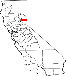
Location of Sierra County in California
This is a list of the National Register of Historic Places listings in Sierra County, California.
This is intended to be a complete list of the properties and districts on the National Register of Historic Places in Sierra County, California, United States. Latitude and longitude coordinates are provided for many National Register properties and districts; these locations may be seen together in an online map.[1]
There are 13 properties and districts listed on the National Register in the county.
- This National Park Service list is complete through NPS recent listings posted October 4, 2018.[2]
Current listings
| [3] | Name on the Register[4] | Image | Date listed[5] | Location | City or town | Description |
|---|---|---|---|---|---|---|
| 1 | 1872 California-Nevada State Boundary Marker | 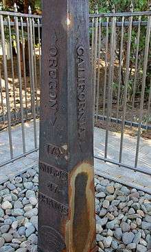 |
August 27, 1981 (#81000387) |
Northwest of Verdi on the California/Nevada border 39°31′28″N 120°00′07″W / 39.524389°N 120.001861°W |
near Verdi, Nevada | |
| 2 | Durgan Bridge | 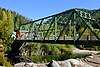 |
July 10, 2012 (#12000398) |
Nevada St. 39°33′35″N 120°49′46″W / 39.559714°N 120.8294°W |
Downieville | |
| 3 | Foote's Crossing Road | January 29, 1981 (#81000180) |
Tahoe National Forest 39°25′42″N 120°54′58″W / 39.428333°N 120.916111°W |
Nevada City | ||
| 4 | Forest City | 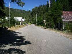 |
September 3, 1996 (#96000942) |
Off of Mountain House Rd., at the junction of North and South Forks, Tahoe National Forest 39°29′25″N 120°51′05″W / 39.490278°N 120.851389°W |
Forest City | |
| 5 | Hansen Bridge | .jpg) |
July 10, 2012 (#12000399) |
E. River St. between Upper Main and Pearl Sts. 39°33′47″N 120°49′31″W / 39.56313°N 120.82517°W |
Downieville | |
| 6 | Hawley Lake Petroglyphs | May 6, 1971 (#71000200) |
Address Restricted |
Gold Lake | ||
| 7 | Hospital Bridge | 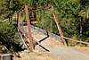 |
July 10, 2012 (#12000400) |
Upper Main St. over the Downie River 39°34′11″N 120°49′21″W / 39.569689°N 120.822489°W |
Downieville | |
| 8 | Jersey Bridge | 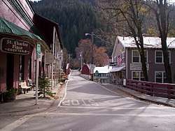 |
July 10, 2012 (#12000401) |
CA 49 from Main to Commercial Sts. 39°33′36″N 120°49′40″W / 39.559867°N 120.827863°W |
Downieville | |
| 9 | Kyburz Flat Site | 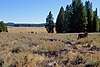 |
November 12, 1971 (#71000201) |
Address Restricted |
Loyalton | |
| 10 | Sardine Valley Archeological District | May 6, 1971 (#71000202) |
Address Restricted |
Truckee | ||
| 11 | Sierra County Sheriff's Gallows | 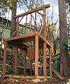 |
February 15, 1990 (#90000118) |
Galloway Rd. and Courthouse Sq. 39°33′30″N 120°49′46″W / 39.558333°N 120.829444°W |
Downieville | |
| 12 | Sierraville School | 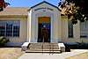 |
September 28, 2017 (#100001666) |
305 S. Lincoln St. 39°35′04″N 120°22′07″W / 39.584377°N 120.368721°W |
Sierraville | |
| 13 | Stampede Site | October 14, 1971 (#71000203) |
Address Restricted |
near Verdi, Nevada |
See also
| Wikimedia Commons has media related to National Register of Historic Places in Sierra County, California. |
References
- ↑ The latitude and longitude information provided in this table was derived originally from the National Register Information System, which has been found to be fairly accurate for about 99% of listings. For about 1% of NRIS original coordinates, experience has shown that one or both coordinates are typos or otherwise extremely far off; some corrections may have been made. A more subtle problem causes many locations to be off by up to 150 yards, depending on location in the country: most NRIS coordinates were derived from tracing out latitude and longitudes from USGS topographical quadrant maps created under the North American Datum of 1927, which differs from the current, highly accurate WGS84 GPS system used by most on-line maps. Chicago is about right, but NRIS longitudes in Washington are higher by about 4.5 seconds, and are lower by about 2.0 seconds in Maine. Latitudes differ by about 1.0 second in Florida. Some locations in this table may have been corrected to current GPS standards.
- ↑ "National Register of Historic Places: Weekly List Actions". National Park Service, United States Department of the Interior. Retrieved on October 4, 2018.
- ↑ Numbers represent an ordering by significant words. Various colorings, defined here, differentiate National Historic Landmarks and historic districts from other NRHP buildings, structures, sites or objects.
- ↑ National Park Service (2010-07-09). "National Register Information System". National Register of Historic Places. National Park Service.
- ↑ The eight-digit number below each date is the number assigned to each location in the National Register Information System database, which can be viewed by clicking the number.
| Topics | |
|---|---|
| Lists by states |
|
| Lists by insular areas | |
| Lists by associated states | |
| Other areas | |
| |
Municipalities and communities of Sierra County, California, United States | ||
|---|---|---|
| City | | |
| CDPs | ||
| Unincorporated communities | ||
| Ghost towns |
| |
This article is issued from
Wikipedia.
The text is licensed under Creative Commons - Attribution - Sharealike.
Additional terms may apply for the media files.